Tag Archives: Maps

The best times for holiday travel and shopping, according to Maps data

The holidays are upon us once again. While we love the crinkle of wrapping paper and the smell of freshly baked gingerbread, the holiday season’s long lines and endless traffic are enough to turn anyone into a Scrooge. To help you navigate this holiday season like a pro, we’ve pulled together Google Maps traffic predictions, popular times and activity trends to get you out the door and on your merry way with ease.

The best times for Thanksgiving travel

Whether you’re hitting the road early or heading out on Thanksgiving day, you can outsmart a potential slowdown by choosing the right time to leave. We took a look at last year’s Thanksgiving traffic patterns across more than 20 major U.S. cities to help you plan your trip and quit traffic cold turkey.

? When to hit the road. The best time to get on the road before Thanksgiving is typically Monday at 8 p.m. local time. Try to avoid driving on Tuesday or Wednesday around 4 and 5 p.m., as that’s typically when Thanksgiving traffic hits its peak.

? Turkey-day travels. Planning to make your turkey trot on Thanksgiving day? Try to hit the road before noon or after 5 p.m. Roads are typically more congested between 3-5 p.m., which could cause some ruffled feathers.

? Black Friday shopping. If you manage to emerge from your Thanksgiving food coma to shop ‘til you drop, there’s no sense in getting caught in traffic! On Black Friday, we typically see traffic pick up around noon and peak around 4 p.m. in most places across the U.S. You’ll see fewer cars on the road at 7 a.m., 10 a.m., and between 7-8 p.m.

? Home for the weekend. To make sure your journey home is all gravy after the festivities are over, try to avoid the roads at 4 p.m. on Saturday and Sunday. Typically the best times to leave are 6 a.m. or 8 p.m. local time.

The best times to travel, shop and run errands

Holiday crowds are snow joke. We looked at Popular Times information to determine the best and worst times to visit the places you need most during the holidays — so you can spend more time celebrating and less time waiting in line.

✈️ Airports. Turkeys aren’t the only ones trying to fly out of here! Airports in the U.S. are typically at their busiest on Saturdays at noon, so build in extra time if you’re traveling around then. Airports are at their least busy on Wednesdays around 8 p.m.

? Bakeries. Looking for a sweet treat? You can expect to stand in line at the bakery on Saturday at 10 a.m., but you’ll have the best chance of avoiding the crowds if you visit on Monday at 3 p.m.

? Grocery Stores. On a mission to get everything you need to be the hostess with the most-est? Grocery stores across the U.S. are typically busiest on Sunday at 1 p.m. and least busy on Tuesday at 9 a.m.

? Post Offices. We can’t all deliver our gifts in a sleigh, but you can slay your trip to the post office. Visit on Friday around noon to beat the crowds, and make sure you avoid the typical Tuesday 3 p.m. rush.

?️ Shopping Center. For when your presents is requested. Visit a local mall or shopping center around Monday at 3 p.m. and you’ll be in and out faster than you can say Kris Kringle, but visit on Saturday at 1 p.m. and yule surely be sorry.

The most popular holiday activities

From Christmas tree farms and holiday markets to ice skating rinks, we took a look at how popular holiday activities compare in each state. Dive in for some tree-mendous activity trends!

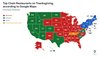
? Order up! The most popular chain restaurants people navigate to on Thanksgiving are McDonald’s, Starbucks, and Dunkin’, according to Google Maps data. Tennessee is the only state that doesn’t favor one of these three, opting for Cracker Barrel (Old) Country Store instead!

A map of the United States showcasing which chain restaurant is most popular in each US state with McDonald's indicated by red, Starbucks indicated by green and Dunkin' indicated by blue.

Among the most popular holiday activities are Christmas tree farms and ice skating rinks, according to Google Maps direction requests. Let’s see how they compare:

⛸️ Ice, ice baby. Ice skating rinks took the lead in 33 states: Alaska, Arizona, California, Colorado, Connecticut, Delaware, Florida, Georgia, Idaho, Illinois, Indiana, Kentucky, Maryland, Massachusetts, Michigan, Minnesota, Missouri, Montana, Nebraska, Nevada, New Hampshire, New Jersey, New Mexico, New York, North Dakota, Oklahoma, Rhode Island, South Dakota, Tennessee, Utah, Virginia, Texas and Wyoming.

? Rockin’ around the Christmas tree. Christmas tree farms were the more popular activity in 17 states. The tree-huggin’ states are: Alabama, Arkansas, Hawaii, Iowa, Kansas, Louisiana, Maine, Mississippi, North Carolina, Ohio, Oregon, Pennsylvania, South Carolina, Vermont, Washington, West Virginia and Wisconsin.

Whether you’re traveling far and wide or welcoming friends and family to your home, we know you’ve got your work cut out for you. Check out these Google Maps tips and tricks for navigating the holidays with ease.

5 Google Maps tips for less stress this holiday season

It’s the most wonderful time of the year! Bustling shoppers, home-cooked meals and quality time with loved ones.

Even with all this holiday cheer, the season can feel overwhelming. To help you save time, money and your sanity, here are five must-know Google Maps tips and tricks to navigate the busy holiday season with ease.

Search for stops along your route ?

Forgot something important for your holiday gathering? Start navigating to your destination and tap on the magnifying glass on the top right-hand side of the app. You’ll find grocery stores, rest stops, gas stations, hotels and more along the way so you can avoid a major detour.

Share your ETA ⌚

Running late to the festivities? Let friends and family know you’re on your way by sharing your ETA right from Maps. When navigating, tap on the bottom screen and then on “Share trip progress.”

Drive sustainably and save money on gas ♻️

Use eco-friendly routing to see and choose the most fuel or energy-efficient route to your destination — whether it’s an ice rink or a tree farm — whenever you navigate with Google Maps. You can also search for “gas prices'' to see the price of fuel at stations nearby so you can pick the cheapest option.

Find your way indoors fast with the Directory tab ?️

If you’re planning to shop or travel this season, you can search for any mall, airport or transit station and tap on the “Directory” tab to see what businesses are inside — like if a specific car rental company is located at the airport. You’ll also see helpful details like what floor a place is on and if it’s open.

Avoid holiday crowds with busyness information ?

Nothing dampers a festive mood like long lines. Search for any place on Google Maps — like a bakery, grocery store or airport — and pull up its business page. Scroll down to see how busy it is at the moment or how busy it tends to be at a given day and hour to save time.

Still hungry for more? Check out these Google Maps traffic predictions, popular times, and activity trends — we promise they’re pumpkin to talk about!

Kwentuhan: Sharing our stories this Filipino American History Month

“Kwentuhan” roughly translates to “sharing stories” in English. For Filipino American History Month, or Kapamilya Month as our Filipino Googler Network refers to it, we sat down with Paolo Malabuyo, Director of User Experience in Google Maps and executive sponsor of the Filipino Googler Network, to learn about his story.

As a child growing up in the Philippines, we heard you were somewhat of a Lego competition legend. How did this kickstart your interest in working in UX and design?

I was the youngest of four and I always felt like I was in the shadow of my older, smarter, more athletic and more accomplished siblings. I don’t recall having many ideas about what I wanted to be when I grew up, until my grandmother immigrated to the United States in the 1960s and started sending small handfuls of Lego pieces through the mail.

This started my fascination with Lego and culminated in my participation in Lego competitions across the Philippines. I still think that the greatest job in the world is designing Lego sets.

I immigrated to the States right before my 12th birthday and picked up drawing, reading, and crafting. This developed into a real affinity for art. I ended up getting a BFA in art and minors in communication design, art history and Chinese studies. I also took basic programming classes and learned web design by emulating early websites.

Like Lego pieces, my early days of creatively building, combined with my art education and CS study were what constructed my career today. I got my first role as a graphic designer which started my roundabout journey to become a UX designer, leader and educator.

Can you talk about your role at Google?

I lead the cross-disciplinary user experience teams for Geo Auto and Geo Sustainability. In Auto, we design and deliver the in-car, embedded Google Maps experiences for navigation, routing, and situational awareness so that drivers are safer and more confident, with a major focus on electric vehicles. In Sustainability, we provide platforms, insights, and solutions that help users and partners tackle climate change – the preeminent challenge for humanity today. It’s an incredibly interesting portfolio and it’s such a privilege to work with our teams and clients.

As an executive sponsor for the FIlipino Googler Network, I get to work closely with other teams across Google on projects that impact the Filipino community. One example is the work happening on Maps to help business owners identify themselves, including the introduction of the Asian-owned attribute earlier this year. This attribute will help many Filipino businesses be recognized by current and future customers.

What else is Google doing in support of Filipino culture?

It’s great to see how Google’s products and services are celebrating Filipino culture and elevating our voices. This month, we ran a beautiful Google Doodle in the Philippines which celebrated the Regatta de Zamboanga, an annual sailing competition from the southern part of the country.

Six sailboats with the letters on the flags spelling GOOGLE.

Google TV is highlighting recent movies and TV shows that tell Filipino American stories and feature Filipino American lead actors in its “For you” tab.

The Google TV interface on the For you page displaying an image of Jacob Batalon with fangs promoting a TV show “Reginald the Vampire”

One of Google TV's highlighted shows for Filipino American History Month

And Google Arts & Culture has teamed up with amazing organizations to celebrate the rich culture and history of the Philippines, including the Filipinas Heritage Library, Filipino Street Art Project, and the Ballet Philippines.

Earlier, you talked about how you grew up in the Philippines. What role do you think Google has to play in supporting the local community?

Google has amazing resources that can help the people in the Philippines. We’ve done a lot to support inclusive distance learning, from a Google.org grant to help teachers, to the national deployment of G Suite for Education to 22 million learners in partnership with the Department of Education. We’re collaborating with local telecommunications companies to bring mobile access to learning tools and started a virtual training camp for Filipino YouTubers to accelerate development of quality learning content on the platform. Just last month, we announced we will be giving away Google Career Certificate scholarships to 39,000 Filipino youths.

Commitments like these are super valuable, and I’m grateful for the work to come.

Source: Google LatLong


Search outside the box: How we’re making Search more natural and intuitive

For over two decades, we've dedicated ourselves to our mission: to organize the world’s information and make it universally accessible and useful. We started with text search, but over time, we've continued to create more natural and intuitive ways to find information — you can now search what you see with your camera, or ask a question aloud with your voice.

At Search On today, we showed how advancements in artificial intelligence are enabling us to transform our information products yet again. We're going far beyond the search box to create search experiences that work more like our minds, and that are as multidimensional as we are as people.

We envision a world in which you’ll be able to find exactly what you’re looking for by combining images, sounds, text and speech, just like people do naturally. You’ll be able to ask questions, with fewer words — or even none at all — and we’ll still understand exactly what you mean. And you’ll be able to explore information organized in a way that makes sense to you.

We call this making search more natural and intuitive, and we’re on a long-term path to bring this vision to life for people everywhere. To give you an idea of how we’re evolving the future of our information products, here are three highlights from what we showed today at Search On.

Making visual search work more naturally

Cameras have been around for hundreds of years, and they’re usually thought of as a way to preserve memories, or these days, create content. But a camera is also a powerful way to access information and understand the world around you — so much so that your camera is your next keyboard. That’s why in 2017 we introduced Lens, so you can search what you see using your camera or an image. Now, the age of visual search is here — in fact, people use Lens to answer 8 billion questions every month.

We’re making visual search even more natural with multisearch, a completely new way to search using images and text simultaneously, similar to how you might point at something and ask a friend a question about it. We introduced multisearch earlier this year as a beta in the U.S., and at Search On, we announced we’re expanding it to more than 70 languages in the coming months. We’re taking this capability even further with “multisearch near me,” enabling you to take a picture of an unfamiliar item, such as a dish or plant, then find it at a local place nearby, like a restaurant or gardening shop. We will start rolling “multisearch near me” out in English in the U.S. this fall.

Gif shows how you can use the Google app to search using images and text simultaneously by taking a picture and then adding text to your query.

Multisearch enables a completely new way to search using images and text simultaneously.

Translating the world around you

One of the most powerful aspects of visual understanding is its ability to break down language barriers. With advancements in AI, we’ve gone beyond translating text to translating pictures. People already use Google to translate text in images over 1 billion times a month, across more than 100 languages — so they can instantly read storefronts, menus, signs and more.

But often, it’s the combination of words plus context, like background images, that bring meaning. We’re now able to blend translated text into the background image thanks to a machine learning technology called Generative Adversarial Networks (GANs). So if you point your camera at a magazine in another language, for example, you’ll now see translated text realistically overlaid onto the pictures underneath.

Gif shows how with the new Lens translation update, you can use your camera to translate text in another language realistically overlaid onto the pictures underneath.

With the new Lens translation update, you’ll now see translated text realistically overlaid onto the pictures underneath.

Exploring the world with immersive view

Our quest to create more natural and intuitive experiences also extends to helping you explore the real world. Thanks to advancements in computer vision and predictive models, we're completely reimagining what a map can be. This means you’ll see our 2D map evolve into a multi-dimensional view of the real world, one that allows you to experience a place as if you are there.

Just as live traffic in navigation made Google Maps dramatically more helpful, we’re making another significant advancement in mapping by bringing helpful insights — like weather and how busy a place is — to life with immersive view in Google Maps. With this new experience, you can get a feel for a place before you even step foot inside, so you can confidently decide when and where to go.

Say you’re interested in meeting a friend at a restaurant. You can zoom into the neighborhood and restaurant to get a feel for what it might be like at the date and time you plan to meet up, visualizing things like the weather and learning how busy it might be. By fusing our advanced imagery of the world with our predictive models, we can give you a feel for what a place will be like tomorrow, next week, or even next month. We’re expanding the first iteration of this with aerial views of 250 landmarks today, and immersive view will come to five major cities in the coming months, with more on the way.

Gif shows how immersive view allows you to determine what a place will be like when you visit, including how busy it will be and what it will look like inside.

Immersive view in Google Maps helps you get a feel for a place before you even visit.

These announcements, along with many others introduced at Search On, are just the start of how we’re transforming our products to help you go beyond the traditional search box. We’re steadfast in our pursuit to create technology that adapts to you and your life — to help you make sense of information in ways that are most natural to you.

New ways to make more sustainable choices

Search interest in terms like electric vehicles, solar energy and thrift stores reached new highs globally over the past year — suggesting that people are looking for ways to practice sustainability in their daily lives. That’s a trend we love to see.

Averting climate change requires all of us to act. At Google, we aim to make our operations more sustainable (like our goal to achieve net-zero emissions across all of our operations and value chain by 2030), and also make it easier for people and businesses to make more sustainable choices. At our Search On event, we’re sharing new ways Google can help you be more sustainable.

Find more efficient cars and eco-friendly routes

If you’re in the market for a new car, you’re probably looking to lower your fuel costs and emissions. Over the next few days, we’ll start to show the annual fuel cost for cars in search results. We’ll also show emissions estimates, so you know how a particular model you have your eye on compares to similar ones.

Animation showing the annual fuel cost of a Toyota RAV4 Hybrid compared to typical cars.

If you’re looking to buy an electric vehicle — which more than a quarter of new car buyers are — we’ll soon show estimated costs, range and charging speeds for electric vehicle models. Plus, you’ll be able to easily find public charging stations near you that are compatible with each electric vehicle. For U.S. shoppers, we’ll also show available federal tax incentives, which make the switch to electric cars even more appealing.

Animation showing the charging speeds of a Ford F-150 Lightning.

To help save money on gas, drivers have also been using our eco-friendly routing feature, which helps people find the most fuel-efficient routes using insights from the U.S. Department of Energy’s National Renewable Energy Laboratory and data from the European Environment Agency. We’re now making it easy for companies — like delivery or ridesharing services — to become more sustainable by using the same eco-friendly routing capability in their apps. Check out our blog post about Maps updates to learn more about this feature.

Shop pre-owned items

Whether it’s sprucing up your wardrobe with new items or digging up hidden gems from a few seasons ago, clothing choices have an impact on emissions and waste. After all, clothing is responsible for 10% of global carbon emissions. Buying pre-loved items is a small action you can take to live more sustainably. Later this year on Search, we’ll highlight which products are pre-owned, making it easier than ever for you to make sustainable choices when shopping and maybe even save some money!

A jacket with a pre-owned label and green leaf icon.

Brussel up a healthier dinner

Some food ingredients are more sustainable than others. But it's not always easy to find out how the environmental impact of chicken compares to fish or how eggs compare to tofu.

Soon, when you search for certain recipes like “bean recipes” or “broccoli chicken,” you can see how one choice compares with others thanks to ingredient-level emissions information from the United Nations. This feature will soon be available worldwide to English language users.

A search for panang curry with tofu, showing how tofu compares to other proteins in terms of emissions.

Whether you’re buying pre-owned products and planning your next meal or road trip, these small changes can add up to a big impact. The future of our planet — and everyone on it — deserves nothing less.

4 new updates that make Maps look and feel more like the real world

Google Maps has always pushed the boundaries of what a map can do. Features like live traffic transformed how people get from point A to B, and insights like busyness information changed the way people make decisions about where to go. At Search On, we shared how we’re reimagining Google Maps yet again, with a visual and intuitive map that allows you to experience a place as if you’re there — all thanks to the newest advancements in computer vision and predictive models.

Get a vibe check before you visit ?✅

If you’re visiting a new neighborhood, it can be hard to figure out what's worth exploring, what’s new, and what the local gems are. Soon, with our new neighborhood vibe feature, you’ll be able to select a neighborhood and see the most popular spots come to life thanks to helpful photos and information from the Google Maps community right on the map. Say you’re on a trip to Paris — you can quickly know if a neighborhood is artsy or has an exciting food scene so you can make an informed decision on how to spend your time. To determine the vibe of a neighborhood, we combine AI with local knowledge from Google Maps users who add more than 20 million contributions to the map each day — including reviews, photos and videos. Neighborhood vibe starts rolling out globally in the coming months on Android and iOS.

Alt text: Still images of Google Maps’ new neighborhood vibe feature, which shows photos and reviews on top of the map

See popular places right on the map with neighborhood vibe.

Now live: 250 landmark aerial views around the ?

At I/O, we introduced immersive view, an entirely new way to explore the world, letting you see stunning multi-dimensional views of an area with critical information like the weather, traffic and busyness layered on top. Today, we’re launching over 250 photorealistic aerial views of global landmarks that span everything from the Tokyo Tower to the Acropolis — marking a significant step toward a more immersive map.

GIF of Google Maps aerial views for the Tokyo Tower, Acropolis, and Empire State Building

See 250 photorealistic aerial views of global landmarks.

Using predictive modeling, immersive view automatically learns historical trends for a place to determine what an area will be like tomorrow, next week and even next month. So if you’re visiting San Francisco and want to visit Oracle Park, you’ll have all the information you need to plan your day. You’ll be able to see where the parking lots and entrances are and if the weather will be chilly on game day so you can bring a jacket. Need to find a bite to eat after the game? We make it easy to experience what restaurants are like nearby with the ability to glide down to street level, peek inside and know how busy it’ll be. Immersive view rolls out in the coming months in Los Angeles, London, New York, San Francisco and Tokyo on Android and iOS.

A breakthrough for Live View ?

Beyond helping you experience a place before you visit, we’re also changing the way you explore it in the moment. Three years ago, we reinvented the way people orient themselves while walking with Live View, which overlays arrows and directions right on top of your world so you don’t get lost. Now, we’re expanding the underlying technology — the first of its kind to be available broadly — to launch a new feature called search with Live View, which helps you find what’s around you more intuitively.

Say you’re heading to an outdoor market and need to take cash out. With search with Live View, simply lift your phone to search and instantly see the ATMs in an area. You can also spot different places — including coffee shops, grocery stores and transit stations. We'll show you business hours and how busy a place is, and you can tap on any location to view more details, like what services the barber shop down the street offers. Search with Live View starts rolling out in London, Los Angeles, New York, San Francisco, Paris and Tokyo in the coming months on Android and iOS.

GIF of search with Live View, which shows how you can lift your phone to find places like ATMs overlaid on top of the map

Lift your phone to explore nearby places with search with Live View.

Helping companies and developers operate more sustainably ♻️

Recently, we launched eco-friendly routing in the U.S., Canada, and Europe, which uses a new routing model to let drivers see and choose the most fuel-efficient route to their destination, using insights from the U.S. Department of Energy’s National Renewable Energy Laboratory and data from the European Environment Agency. Since launching in the U.S. and Canada, eco-friendly routing has helped remove an estimated half a million metric tons of carbon emissions — the equivalent of taking 100,000 fuel-based cars off the road. To drive an even bigger impact, we’ll soon expand this same technology to third-party developers through Google Maps Platform.

This means that companies of all sizes and industries — like delivery or ridesharing services — will have the option to enable eco-friendly routing in their apps and measure fuel consumption and savings for a single trip, multiple trips, or even across their entire fleet to improve performance. Developers will even have the ability to select an engine type to get the most accurate fuel or energy efficiency estimates when choosing an eco-friendly route. Eco-friendly routing for developers will be available in preview later this year, wherever it’s available on Google Maps.

With today’s announcements, we’re building a visual-first Maps experience that helps everyone explore and navigate the world more naturally — while getting there more sustainably.