Tag Archives: Maps

More ways to drive sustainably and save money with Google Maps

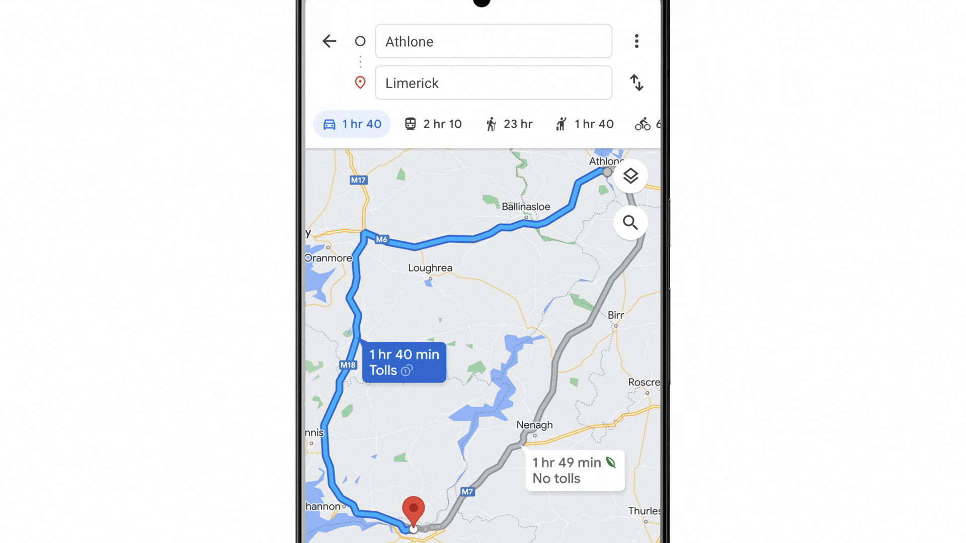
Imagine you’re planning a day trip from your home in Athlone, Ireland over to Limerick – over an hour and a half journey. To decide how to get there, you open Google Maps — which offers multiple navigation options including walking, cycling and public transit directions. Given the length of the trip, it makes the most sense to drive, and you immediately search for the fastest route.

But what if there were other options: A route that would take nine minutes more, but would save nearly 30% of your expected fuel consumption?

Now rolling out: Eco-friendly routing across Europe

This is now possible thanks to eco-friendly routing in Google Maps, which starts rolling out in nearly 40 countries across Europe today. With eco-friendly routing, you can choose a route that’s optimized for lower fuel consumption, which helps you save money on fuel and reduce carbon emissions — something that’s top of mind for many Europeans. And this is a real concern - according to Statista’s 2022 report, road transportation is the largest source of carbon emissions throughout Europe.

Now, in addition to showing the fastest route, Google Maps will also display the one that's most fuel efficient, if it doesn’t happen to also be the fastest. With just a few taps, you can see the relative fuel savings and time difference between the two routes and choose the one that works best for you. Always want to choose the fastest route, no matter what? That’s okay too — simply adjust your preferences in Settings.

Eco-friendly routing is making an impact around the world. Since launching in the U.S. and Canada, it’s already estimated to have helped remove more than half a million metric tons of carbon emissions — equivalent to taking 100,000 fuel-based cars off the road. We also recently rolled out the feature in Germany.

GIF of Ireland route map

With eco-friendly routing, Google Maps will show you both the fastest route and the one that’s most fuel-efficient — so you can choose whichever one works best for you.

Get the most fuel-efficient route based on engine type

The most fuel-efficient route will vary based on what type of engine you have. For example, diesel engines are usually more efficient at higher speeds than petrol or gas engines, while hybrid and electric vehicles perform better in stop-and-go traffic. That’s why, in the coming weeks, we’ll make it possible for drivers using eco-friendly routing in Europe, the U.S. and Canada to select their engine type — petrol or gas, diesel, hybrid or electric vehicle (EV) — in order to get the best route and most accurate fuel or energy efficiency estimates.

This technology is made possible thanks to insights from the U.S. Department of Energy’s National Renewable Energy Laboratory (NREL) and data from the European Environment Agency. By pairing this information with Google Maps driving trends, we were able to develop advanced machine learning models trained on the most popular engine types in a given region.

A gif of Google’s Maps’ eco-friendly routing

In the coming weeks, we’ll make it possible for drivers using eco-friendly routing in Europe, the U.S. and Canada to select their car type — petrol or gas, diesel, hybrid or electric vehicle (EV).

Helping you make sustainable choices with Google Maps and beyond

Whether you’re staying local or traveling, Google can help you get where you need to go more sustainably with a few helpful tips:

  • It’s electric! If you have an electric vehicle, just search for “EV charging station” on Google Maps to see charging stations nearby, along with helpful details, like port types and charging speeds. And for some stations, you can even see if a charger is available right now, helping you avoid the wait and save valuable time.
  • Swap four wheels for two. Often, the most sustainable choice doesn't involve a car at all, and Google Maps can help you with alternate ways to get around. We recentlyannounced more cycling route information, including a more detailed breakdown of your route and whether you’ll encounter heavy car traffic, stairs or steep hills on the way. And you can find nearby bike and scooter shares in over 500 cities around the world including Barcelona, Berlin, London, Paris, and Rome.
  • Walking the walk. Google Maps offers turn-by-turn directions for pedestrians. To ensure you’re not walking the wrong way, Live View uses augmented reality to display arrows and directions clearly overlaid on the map. Plus, you can preview your walking route with Street View.
  • Navigate public transport with ease. By tapping on the transit icon in Directions, you get directions to your destination by bus, train, subway and even ferry. When available, you can see real time arrival and departure times, transfers, and service delays. And Google Maps gives you all the information you need to be prepared, like how crowded your ride will be, what the temperature is like, and if there are wheelchair-accessible routes available.
  • Sleep more sustainably. Google Search helps you find hotels that have made significant commitments to green practices. Hotels that are certified for meeting high standards of sustainability from certain independent organizations, like Green Key or EarthCheck, will have an eco-certified badge next to their name. This helps you understand their eco-friendly practices, from waste reduction to energy efficiency to water conservation measures.

All this is part of our commitment to empower 1 billion people through Google products by the end of the year - by making the sustainable choice an easier choice.

Supporting Asian-owned businesses in your community

When I was 5, our family moved from New York City to the countryside outside of the city. My brother and I were the only kids of Asian descent in our elementary school. Our father was born in Yamaguchi, Japan to a Japanese mother and American father, and I always felt proud of that — but in this new environment, I instantly felt different.

These early experiences showed me just how important it is to show up for and with communities. Over the past two years, COVID-related small business closures and targeted acts of violence have reinforced the importance and impact of allyship — and have underscored how critical it is to support historically marginalized communities, including our Asian community. That’s why we’re announcing a new way to help Asian-owned businesses thrive.

Celebrating Asian-owned businesses

Starting today, US businesses can now add the Asian-owned attribute to their Business Profile on Search and Maps. In the coming weeks, ad-supported publishers will be able to identify as Asian-owned in Display & Video 360’s Marketplace, too.

A screenshot of East West Shop on Google Maps, showcasing the business identifies as Asian-owned, LGBTQ+ Friendly, and women-owned.

Businesses can opt in to adopt the attribute on their Business Profile and can easily opt out at any time. Once the attribute appears on a Business Profile, users will also be able to see the attribute. This update builds on the Black-owned, Latino-owned, veteran-owned, women-owned andLGBTQ+ owned business attributes, and is another way people can support a diversity of businesses across Google’s products and platforms.

As we were building this feature, we worked with hundreds of Asian-owned businesses to ensure the attribute celebrates our diverse and unique cultures. During that process, I was particularly struck by what Dennys Han, owner of East West Shop, shared with us about the power of community: “If someone is trying to accomplish something, the entire local Korean community will band together to help it come together. The idea of the community and group as a whole uplifting each other is fundamental to what we do.”

Building up Asian-owned businesses’ digital skills

Over the past few years, Grow with Google has partnered with the US Pan Asian American Chamber of Commerce (USPAACC) to help Asian-owned small businesses grow. To date, we’ve helped more than 20,000 Asian-owned businesses expand their digital skills through workshops focusing on topics like e-commerce tools, design thinking for entrepreneurs and making decisions using analytics.

Today, we’re building upon that partnership. Together, USPAACC and Grow with Google will help an additional 10,000 Asian-owned small businesses gain digital skills to help them grow their businesses. And as the internet continues to grow in importance for shopping, nearly one quarter of Asian-owned business owners said their most important channel towards building community and financial support was across social media and online.

It’s our hope the Asian-owned attribute brings people together and provides our communities with much-needed recognition: to help them be seen and thrive. We are excited to spotlight Asian-owned businesses and highlight part of what makes our community unique and important.

A collage of 6 Asian-owned businesses, 3 on the top and 3 on the bottom with the Asian-owned attribute icon in the middle, a circular design with a red and yellow intertwining flower at its’ core. The top row of 3 (from left to right) include: pottery cups and plates on a table with Tortoise General Store owner holding 2 small dishes in the background, Good Hause Marketing Agency Business owner working, holding a marketing design poster board, and 3 t-shirts (black, pink, and white) hanging in East / West Shop. The bottom row of 3 (from left to right) include: the owner of Bollypop in red traditional dress from India twirling, the storefront of Jitlada restaurant, and the owner of Peru Films facing towards the right, looking down, and crossing his arms.

Top left to right:

Tortoise General Store, Owned by Taku and Keiko Shinomoto

Good Hause, Owned by Brittany Tran

East / West Shop, Owned by Dennys Han

Bottom left to right:

Bollypop, Owned by Aakansha Maheshwari

Jitlada, Owned by Sugar Sungkamee

Peru Films, Owned by Tanmay Chowdhary

Source: Google LatLong


Googlers for climate: meet Lisa Arendt

Based in Zürich, Lisa is Product Partnerships Manager for Maps. She helps partners to integrate their charging station locations into Google Maps, which makes recharging as seamless as possible for e-drivers.

And by seamless, she means that charging should be as easy, safe and reliable as it is with petrol- or diesel-powered cars.

She grew up in a small village near Schwerin, where she still goes to unwind. "There were no buses there. Just one empty street and maybe 20 houses. It's the kind of place where you had to make do with a bicycle," she says.

She doesn't even own a car. "In Zürich, you just don't need one." But today, she owns three bicycles: "A mountain bike for taking a spin in the countryside, a fast racing bike and an old city bike that I won't miss if it gets stolen", she says, laughing.

Lisa is always looking for the best way to get around — not just in her free time, but also at work.

The first big step was to display charging stations on Google Maps, making it easier for drivers to find the nearest charging station. The next step is smart route planning, which Volvo, for example, has already integrated into its vehicles.

We want to make charging electric cars as easy and reliable as possible

Travel has become a recurring theme in Lisa's life. On her journeys around the world, she always enjoyed finding her own routes and choosing the best options. But she says there was always a bigger question on her mind: How can we improve mobility? Not just for individuals, but for everyone.

Four years ago, Lisa took inspiration from the climate strikes organized by Greta Thunberg, and realized it was time to act. "The next generation is clearly telling us what they want from us. And they want it now." This growing movement changed the way people look at electric vehicles.

At the same time, Google Maps created a new global division with a whole range of experts and introduced the first electric vehicle (EV) feature on their maps. In 2020, the first fully integrated solution was created in collaboration with Polestar and Volvo, which developed an electric car with Google Assistant, Maps and Play built into its system.

Several major car manufacturers are now collaborating with Google to offer all-in-one solutions like this.

We’re changing, so the planet can remain the same

More and more drivers are now benefiting from the work that Lisa and her team are doing. According to the latest Global Electrical Vehicle Outlook report, in 2021 nearly 10% of global car sales were electric, which is four times the market share in 2019. This brought the total number of electric cars on the world’s roads to about 16.5 million, triple the amount in 2018. Sales in Europe showed robust growth (up 65% to 2.3 million) after the 2020 boom. And at the same time, more and more car-sharing providers and public transport companies are investing in e-mobility or planning to transition in the near future.

Discussions are already taking place to see how Google and Lisa's team can support them along the way. Lisa's number-one priority for the future is to expand the project globally. She and her team have already come a long way by creating a practical online atlas for electric vehicle charging stations. Yet there are countless other ways to make mobility more sustainable in the future.

Source: Google LatLong


Three new Maps updates to help plan your next adventure

Who’s got those summertime feelings? If the warmer months have you feeling extra inspired — and excited — to get outside and explore with friends, Google Maps can help you transform the way you coordinate plans and stay connected this summer and beyond. Whether you’re checking out top landmarks in a new city, planning to hop on your bike, or hanging out with friends around town, these updates have you covered.

Experience global landmarks in a whole new way

The summer travel season is in full swing, and people are turning to Google Maps to plan their trips and find helpful information about places they plan to visit — like what time a place is open and how crowded it is. To help you with the trip-planning process, we’re bringing photorealistic aerial views of nearly 100 of the world’s most popular landmarks in cities like Barcelona, London, New York, San Francisco and Tokyo right to Google Maps. This is the first step toward launching immersive view — an experience that pairs AI with billions of high definition Street View, satellite and aerial imagery.

Say you’re planning a trip to New York. With this update, you can get a sense for what the Empire State Building is like up close so you can decide whether or not you want to add it to your trip itinerary. To see an aerial view wherever they’re available, search for a landmark in Google Maps and head to the Photos section.

GIF of aerial landmark views on Google Maps

See photorealistic aerial views of iconic landmarks, right from Google Maps

Get ready for your ride with new cycling route information

More people are hopping on their bikes! Over the past few months, cycling has increased by more than 40% worldwide – which is no surprise given that the warmer weather and high gas prices have people opting for more sustainable transportation choices. Google Maps has provided cycling directions for over 12 years thanks to AI paired with data from cities, trusted cartographic partners and feedback from the Google Maps community. With our new cycling route information, you will soon be able to easily compare bike routes and see even more granular details (when this data is available) to prepare for the ride ahead.

Just get cycling directions to any destination. In addition to seeing the elevation along your route, you’ll also know if you’ll encounter heavy car traffic, stairs or steep hills. You’ll also be able to get a highly detailed breakdown of the route itself so you can know at a glance what type of road you’ll be biking on – like a major road vs. a local street. Gone are the days of unknowingly pedaling up a strenuous hill or on a route with more car traffic than you’re comfortable with.

Be prepared for your ride with more detailed cycling route information

Stay connected and safer on the go

More social outings means more time juggling meetups with friends and family. With new location sharing notifications, you can see when a loved one has arrived or left a place so you can more easily coordinate schedules and have peace of mind. Say you’re headed to a concert with a group of friends. If they’ve already chosen to share their location with you, you can set a notification for the concert venue’s address so you can see when they’ve arrived and meet up quickly. You could also set a notification to see when they’ve left the venue — just in case you get split up. One of the ways I plan to use this feature this summer is when I set out on my solo hiking trip. By asking my sister to set a notification for me so she can see when I’ve returned to the trailhead parking lot gives me peace of mind that someone will know that I made it back safely.

We’ve built this feature with privacy at the forefront. Notifications can only be set for someone who has already chosen to share their location with you. The person who’s shared their location with you will receive multiple reminders to let them know — including both a push notification in the Maps app and an email, along with recurring monthly emails. As always, you’re in control: you choose to stop sharing your location or block someone from setting notifications altogether.

GIF of Location Sharing notifications UI

Stay coordinated and have peace of mind with new location sharing notifications

GIF of Location Sharing notifications controls

Frequent reminders and strong controls: block notifications or stop sharing altogether

Aerial views of landmarks and location sharing notifications are rolling out now globally on Google Maps on Android and iOS, with cycling route information launching in the coming weeks in the hundreds of cities where cycling directions are available.

I’m excellent at planning vacations — steal my tips

I once read that the happiest part of traveling is the planning, and I couldn’t agree more. Before I board a plane, I spend hours researching and documenting the what, where and how of my vacation. Over the past two years I’ve traveled far less than usual, but this year my husband and I decided to go to Italy. It was our first time there, and one of our biggest trips since COVID hit, so I took prepping to a new level. Here’s how I, a self-proclaimed travel nerd, used Google tools to get ready for my getaway.

  1. Get everyone on board with Google Slides.

About a month before our trip, I realized we’d done it all wrong. We weren’t going to have enough time to go hiking, and we were adding unnecessary hours of driving — and with increasing gas prices, that would end up costing way too much. Telling your travel partner you want to start over mere weeks before your trip is tough, and I knew I needed to really sell it…so I made a Google Slides presentation.

A screenshot of a Google Slide presentation in edit mode. The main slide on the screen shows a photo of a Google Map route through Italy and text to the left of the map shows a run down of vacation days segmented by how “chill” they are.

One of the many slides I used to convince my husband we needed to replan our trip.

I’ve used Slides for vacation planning in the past, too — and not just to blow everything up and start over. I’ve also presented what I’ve learned about various travel destinations we’re considering to make a decision. This helps me think clearly about what I want out of a vacation; it feels a bit like I’m vision-boarding the potential trip. And apparently it’s a great selling point, because my husband was completely on board by the end of the presentation.

2. Go off the beaten path with Google Maps.

I often find myself aimlessly “wandering” around Google Maps and Street View, looking for unusually shaped peninsulas or clicking into 360-degree photos that seem impossible to have captured. It’s a great way to cure wanderlust from home, but it’s also an effective way to plan travel. This was how I found a few of our stops in Italy.

Animated GIF of a Google Map showing Italy; the cursor zooms in to Lake Garda revealing the small town of Sirmione.

A little Google Maps “wandering” led me to the town of Sirmione. It caught my eye because it’s basically an island in Italy’s Lake Garda: A narrow road connects Sirmione to the mainland; it’s so tiny that most people park on one side and walk over to the rest of the city, going by foot or golf cart.

An aerial photograph of a town surrounded by water.

An aerial shot of Sirmione taken by my husband.

It’s a place I’ve never heard of, and likely never would have gone.

This is also how we found one of our favorites hikes. The Dolomites are massive — choosing where to visit was overwhelming. But my husband noticed an interesting looking area on Google Earth called Seceda (the fact that it was labeled “Seceda famous view” on Google Maps didn’t hurt our interest either). That was enough for us to add it to our itinerary, and I couldn’t be happier that we did — see for yourself.

A photograph of a mountain landscape, with a dramatically slanted mountain in the foreground that reveals a green pasture on one side and a rocky wall on the other.

3. Take organization to another level with Google Sheets.

Using Google Sheets to organize various parts of a trip is admittedly very obvious compared to my first two tips, but here’s how I like to set things up: I have three pages in a Sheet file — one that functions as a list of things to do in each location, one that lists all of our reservation information and a last tab to collect expenses as we accumulate them while planning and during the course of the trip.

A screenshot of a Google Sheets document showing a list of cities in Italy with various attributes across the sheet listing things like dates, food options, bars, etc.

I like to think of everything listed on this first tab as something potentially worth checking out versus something that’s set in stone. This way, we don’t have to waste time while there looking things up — now if we’re ever wondering “what should we do here?” we can turn to the list for quick, easy access to already researched options.

4. Hit the Search bar…and then the Save button.

I’ve always found it easy to find amazing restaurants and shops when I want to travel, but not quite as simple to grasp what the best outdoor areas are — I want to find the best spot for a sunset, or a viewpoint for an afternoon walk. I’ve found more than a few breathtaking sights by heading to Search and simply entering the name of the city I’m visiting. On the right-hand side, there’s a Knowledge Panel about the location with information like the weather, elevation and local time. Below this is a section that says “Plan a trip,” and underneath that a camera icon next to the words “Things to do.”

And that is how I found arguably the cutest landmark in existence, this “Kiss…Please” sign in Sirmione.

A screenshot of the “Things to do” tab on google.com/travel that’s pulled up the “Kiss…please” landmark. The panel shows various photos and a save option in the right hand corner.

I saved the location straight from this panel so it automatically saved to google.com/travel, and we easily found it when we stopped in the city.

Two people standing in front of a sign that reads “kiss…please” and shows two icons kissing. The two people are also kissing. There is a lake and walkway in the background.

We had to!

5. Stay on budget with a bunch of Google tools.

Traveling is expensive, and while this was definitely a trip we planned and saved for, we were very conscious of not exceeding our budget. I used three Google tools to help us do that. First up, Google Flights. Ahead of buying our flights, I created various alerts to airports in Italy to find the best price and timing. (I also used this feature to price hotels.) Then, while we were there, we used Google Maps’ toll feature, so we could avoid more expensive routes. And of course, there’s the aforementioned Google Sheets tab to collect expenses.

All of these things helped me plan (and thoroughly enjoy planning) my trip — and obviously enjoy the trip itself. Whenever you take your next vacation, hopefully these tips are just as useful for you.

Source: Maps


Inside Scoop: National Ice Cream Day with Google Maps

What better way to beat the hot summer heat than with ice cream? We’re not the only ones who crave this sweet treat. In fact, of all the dishes searched on Google Maps in the U.S., ice cream is the second most-searched. So with National Ice Cream Day on July 17, we couldn’t resist a sweet opportunity to celebrate!

Whether you prefer an elaborate cone, a simple scoop, or chasing the ice cream truck for your favorite popsicle, we have Google Maps ice cream trends that are sure to make you melt.

Here are the most popular ice cream chains in each U.S. state in one fell scoop ?:

A red, blue, green, and yellow map shows the most popular ice cream chain in each U.S. state, broken down by 12 different national ice cream chains.

We all scream for ice cream! There are tons of waffle-y beloved local ice cream spots across the U.S. According to Google Maps, these are the ten most popular:

  1. Sundaes and cones (New York, NY)
  2. Soft Swerve Ice Cream (New York, NY)
  3. Milk & Cream Cereal Bar (New York, NY)
  4. Surreal Creamery (New York, NY)
  5. Glazier Rolled Ice Cream & Boba Tea (San Francisco, CA)
  6. Cones Artisanal Ice Cream Since 1998 (New York, NY)
  7. Little Man Ice Cream (Denver, CO)
  8. Toscanini’s Ice Cream (Cambridge, MA)
  9. Sweet Alchemy Ice Creamery (Seattle, WA)
  10. Shug’s Soda Factory and Ice Cream (Seattle, WA)

Just desserts. Ice cream is the top searched dessert on Google Maps in the U.S., but which states love ice cream the most? These are the top 10 states where anything is popsicle, according to Google Maps data:

  1. Hawaii
  2. Rhode Island
  3. Colorado
  4. Massachusetts
  5. New York
  6. Vermont
  7. Florida
  8. Maine
  9. New Hampshire
  10. Utah

Who says you have to stick to Sundae Funday? Saturday is the most popular day people search for ice cream on Google Maps. So treat yourself this weekend by heading to your favorite spot, or discovering a new one! We even cone-done spoiling your dinner, because you de(soft)serve it!?

Taking pride in our businesses

A couple of years ago, my partner and I moved to Kentucky, not knowing anyone in the state. Before moving, I extensively researched local websites and online magazines, trying to understand the neighborhoods and get a sense of the community. Somewhere along the way I found Lussi Brown Coffee Bar, a local business run by by a queer woman. Not knowing whether I’d get a response, I eagerly reached out through email, asking questions to get a sense of the community. To my delight, the owner, Sarah Brown (she/they), quickly responded and provided an overview of the rich history of the LGBTQ+ community in Lexington. And of course, she shared recommendations of some of their favorite LGBTQ+ owned businesses in the state too!

As we moved into town, Sarah and their girlfriend welcomed us with open arms, very much making the community immediately feel like home. And our physical home brought that same love, too. Unintentionally, we rented an apartment on a short street filled with LGBTQ+ folks from their 20s through their 70s — in fact, our neighbors called it Kentucky’s “Barbary Lane,” a nod to the tight knit, beloved street of LGBTQ+ folks in Armistead Maupin’s novel “Tales of the City.”

A person in a black shirt and shorts sits at a wooden table outside a coffee shop with a rainbow Pride flag hanging in the window

Owner Sarah Brown (she/they) outside of their coffee shop, Lussi Brown

With that same spirit, we want to make it easier for others to find LGBTQ+ owned businesses in their own community. Starting today, merchants in the U.S. with a verified Business Profile on Google can add an LGBTQ+ owned attribute to their profile, making it easier for customers to find and support them through Search and Maps. This new offering joins the Black-owned, Latino-owned, veteran-owned and women-owned business attributes we already offer, and is yet another way people can support diverse businesses.

An attendee of an event co-hosted by NGLCC and Google, sitting in a yellow chair looking forward

As we celebrate Pride, it’s important to remember visibility and representation are critical, all year round. A flag in the window of a small business has the power to bring queer folks together, to celebrate our joy, honor our history, and fight for our diverse community. It’s our hope that this attribute will allow business owners to celebrate their identity and community with the world.

5 of our favorite Android widget features

Widgets are a simple way to personalize any Home screen, putting the information that’s most important to you — your inbox, the weather, your to-do list or even a photo of your dog — front and center.

With the upcoming launch of the nearby traffic widget for Google Maps (more on that soon), 35 Google widgets will be available on Android. To celebrate, we’re spotlighting five of our favorite widget features to help everyone better organize and personalize their Home screens.

Check local traffic with a tap

Whether you’re commuting or heading out to meet friends, Google Maps’ real-time traffic predictions can help you easily plan your route. And with the new nearby traffic widget, launching in the coming weeks, you’ll see this information for your current location right from your Android Home screen. So if you're about to leave home, work, school or anywhere else, you’ll know at a glance exactly what local traffic might be like. And because Android widgets are tappable, you can zoom in and out without opening the Maps app.

Dark green Android wallpaper showing a bamboo palm with the Google nearby traffic widget laid over the top. The widget shows a local map of traffic levels and zooms in and out.

Tap to instantly archive emails

The Gmail widget is a simple way to keep your inbox organized. Just tap to archive an email when it hits your inbox, without having to open the Gmail app.

An Android background with light purple orchids. In the foreground, the Gmail widget animates through the archive feature. An email arrives in the inbox, the archive button is tapped and the email disappears.

Scroll through your to-do list

Lots of you love the scrollable to-do list in the Keep widget. It’s an easy way to keep track of your tasks for the day, and there’s nothing quite as satisfying as crossing them off when you’re done — except maybe scrolling back up to see everything you accomplished.

A light peach-colored pastel background, with the Google Keep widget in the foreground. The widget scrolls through a list of items to pack for vacation.

Skim through your favorite translations

The Google Translate widget’s scrolling feature can help you stay organized, too. If you need to keep certain phrases handy while you’re traveling or speaking with friends and family, you can set them up to always appear on your Home Screen. Just star your favorite translations in the app and you’ll see them right on the widget.

Light orange Android wallpaper of a flower stamen. In the foreground a user scrolls through the Google translate widget, with selected saved translations to use.

Resize widgets to fit your needs

Android widgets are easy to resize and even change shape to help you declutter your Home screen — while keeping helpful features intact. For example, if you make the Drive widget smaller, it’ll turn into a toolbar so you can still quickly search for your files.

Light green Android wallpaper showing a green flower. In the foreground, an animation of different Google Drive widgets resizes.

Get some fresh air outdoors with Google

As temperatures heat up and summer officially begins across the United States, many of us are taking the opportunity to explore the great outdoors. If you have an adventure on the horizon, here are two ways you can use Google tools to stay safe and healthy during your summer activities.

Check the air quality before you head out

When you're visiting a new place or planning outdoor activities, it can be helpful to know the air quality conditions — like whether it’s unusually smoggy. Check out the air quality layer on Google Maps for both Android and iOS, to help you make more informed decisions about whether it’s safe to go on a hike or other outdoor adventures. You’ll see Air Quality Index (AQI), a measure of how healthy (or unhealthy) the air is, along with guidance for outdoor activities, when the information was last updated, and links to learn more.

The air quality layer shows trusted data from government agencies, including theEnvironmental Protection Agency in the U.S. We are also showing air quality information fromPurpleAir, a low-cost sensor network which gives a more hyperlocal view of conditions. To add the air quality layer to your map, simply tap on the button in the top right corner of your screen, then select Air Quality under Map details.

You can also view air quality information from PurpleAir on Nest displays and speakers. The broad coverage of PurpleAir sensors means significantly more people in the U.S. will be able to access vital air quality information directly from their Nest devices.

Two smartphone screens showing the air quality layer on Google Maps

Be prepared during wildfire season

In recent years, wildfires have intensified and increased across the United States and around the world. Google Search interest in “Best air filters for wildfire smoke” and “Best mask for wildfire smoke” has doubled over the past year in the U.S. As wildfire season approaches, these Google features can help you safely navigate wildfires.

Before you head out, turn on the wildfire layer in Google Maps to see more details about active fires in the area thanks to our partnership with the National Interagency Fire Center (NIFC). Or, for larger wildfires, you can use Search to look up "wildfires near me", and we'll surface associated air quality information along with useful information about the fire. In the coming months, we’re also adding smoke data across the U.S. from the National Oceanic and Atmospheric Administration (NOAA) to our air quality information on Google Search.

A smartphone screen showing air quality information on Google Search

We collaborate closely with partners in the weather and air quality space to surface helpful and authoritative information when you need it most. As you head out on hikes, camping trips and other outdoor adventures, we hope these tools help you feel safe and informed so you can enjoy the summer.

Source: The Keyword