Tag Archives: Google Maps

An experiment built with 3D Google Maps imagery, inspired by kids


At Google, we’re always excited to see how technology can help inspire new ways to learn – especially to learn about the world. For years, Google Maps has been adding 3D imagery from all over the world – New York City, the Grand Canyon, Mont Blanc, and more. A few of us started wondering if this 3D imagery could make learning about the world a bit more fun for kids. We started playing with quick prototypes, and even brainstormed with our own kids to get inspired by their sense of curiosity.

Our idea became a new, experimental app called Verne: The Himalayas. It invites you to explore the Himalayas as a 500 foot Yeti named Verne. You can run up Mt. Everest, chase yaks, discover bits of information, ride a jetpack, play Himalayan instruments, and more.

We're excited to share it today as a fun way for anyone to take a summer trip to the tallest mountain range in the world. Get the app for your Android device from the Play Store, or learn more here.

New Google Maps features help you plan your next road trip

Planning road trips in India just became a little easier. With the latest update on Google Maps on Android (coming soon to iOS), now you can plan your road trip with multi-stop directions.

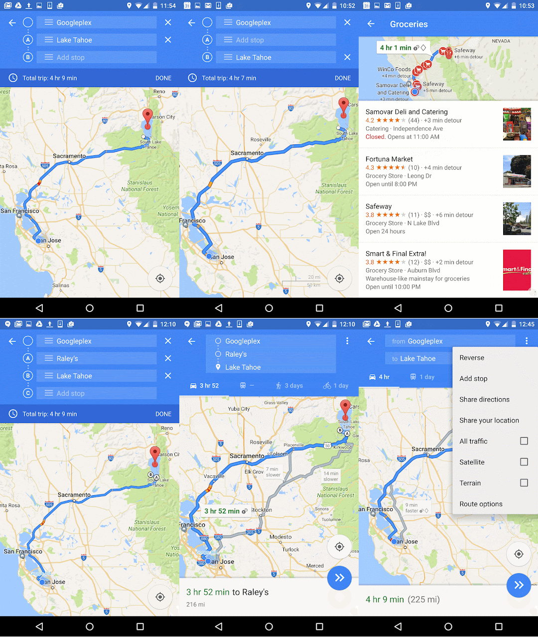
Just open the app, enter a destination, tap the corner menu, and then click “Add stop”. To rearrange the order of your stops, tap and hold the three dot menu to the left of “Add stop” and drag it to the position you want – you can even search for types of places like petrol pumps, ATMs  or restaurants like you normally search. You can add as many stops as you like and once you’re done, tap “Finished” and your multi-stop routing is complete. When you enter navigation mode you’ll have the same seamless driving experience you’re used to, whether you’re running errands or hopping beaches in Goa.

multi-waypoint-2.gif


A lot of the fun of traveling is the memories created while exploring new places with friends, family or even solo. Pictures are a traditional way to remember those moments, but now with “Your Timeline”, users on Android can preserve their travel memories and info in a new way. Google Maps users that have the  Location History enabled can open Your Timeline, select a date from their recent vacation or everyday life and add notes to help remember what they did that day—or save important notes for later.

Timeline screenshot.png

No matter where your travels take you this monsoon season and beyond, these new Google Maps features will get you there and help keep track of all the memories you make along the way.

Posted by Sanket Gupta, Product Manager, Google Maps

How tech-based learning spaces are helping spark creativity


Editor's note: Teachers are uniquely inspiring people. It takes a teacher to innovate in the classroom and inspire a love for learning. We had a great time celebrating these everyday heroes at ISTE this week, and we wanted to highlight a few of them below. Check out the #GoogleEdu and #ISTE2016 hashtags to get a recap of what went on in Denver this week.

The teachers at Laguna Beach Unified School District in California and Sun Prairie Area School District in Wisconsin wanted to give their traditional classroom a reboot. By upending the typical classroom layout that confines students to desks and teachers to the front of the room, they increased student engagement, introducing technology, hands-on learning and group activities.

Laguna Beach designs learning spaces to enhance engagement through movement 


“The classroom is the most neglected element in education right now,” says Mike Morrison, chief technology officer at Laguna Beach Unified School District. “You’ll find rooms with dark projectors, the lights out and the blinds drawn. How could these dark spaces inspire learning?” At Laguna Beach, Morrison and 15 teachers plunged into research on the impact that environment has on the senses — and tested technologies, furniture and even colored lighting. The core elements, says Morrison, boiled down to flexible furniture, multiple monitors and audio amplification.

To replace bulky desks that were designed decades ago to be placed in rows, Morrison and his team chose desks and chairs with wheels that can revolve in any direction. This frees up teachers and students to quickly group desks together and direct attention at any part of the classroom — or at each other. There are standing desks as well, giving students the option to have their legs engaged — a boon for students dealing with attention-deficit disorders, Morrison says.

More monitors and whiteboards provide more space for students to work as teams, instead of just watching the teacher up front. “The walls can then become anything we want them to be,” says Morrison — a place for a test review, a team project or solving a math problem as a class.

Morrison and his team also changed the audio and lighting to help set the mood for different types of learning and make it easier for teachers to be heard. Teachers wear lanyard microphones connected to each classroom’s speaker system. “A teacher who spends the day shouting to be heard is stressed, and so is the class,” Morrison says. Teachers use lighting to change wall colors depending on the activity — yellow to encourage quiet reading time, blue for creativity and brainstorming.

About 40 classrooms have been reconfigured to date, with 20 more to come this summer — and the change is palpable, Morrison says. “Teachers are walking around more, and they’re in touch with what students are doing,” Morrison says. “The atmosphere in classrooms is also much calmer.” 

Laguna Beach Unified School district put together this fun video — a takeoff on TV’s “The Office” — showing off the classroom improvements.


Classrooms become technology incubators for Sun Prairie Area students 


At Sun Prairie Area School District, teachers are inspiring students to be entrepreneurial and engage with technology. They found that by creating dedicated spaces without any of the usual trappings of a classroom, they could motivate students to break out of their comfort zones and think more outside the box.

One of these learning spaces, “Fab Lab,” was created by Stephanie Breunig, a media specialist for the district’s Cardinal Heights Upper Middle School. Students can use the Fab Lab for school or personal projects. The lab has Legos, digital and GoPro cameras, art supplies, circuit boards and software such as GarageBand, recording software for music and Final Cut Pro, a video editing software. In the Fab Lab, students work with teachers to create their own videos or music mashups and internet memes. They've even started learning 3D printing and robotics.
Student working on a project in the Fab Lab
At Sun Prairie Area, teachers are also evolving learning spaces inside the classroom. With Google Maps, students take virtual tours of the world in their geography lessons, learning details about other cultures that they couldn’t find on a regular map. “Students use Google Maps to explore and take interactive tours of other countries,” says Tim Mortensen, 6th and 7th grade social studies teacher at Patrick Marsh Middle School. “When we learned about the pyramids, they could actually see them on the map and they started asking questions about what they’re made of. Some students even explored the surrounding area, wanting to know more about the hotels and restaurants in Egypt and asking questions like why the McDonalds there has different items on the menu.”

“Literacy no longer means just reading and writing words on a page. Technology has created a new definition of literacy that includes digital,” says Curt Mould, director of innovation, assessment and continuous improvement at Sun Prairie Area School District. To teach with technology, teachers are creating learning spaces defined by interactive learning and experimentation.

Laguna Beach and Sun Prairie Area School Districts have discovered just a few of the ways that disrupting the traditional classroom environment can help engage students. From exploring the world with online activities, to simply taking the classroom outside for a lesson, there are an infinite number of ways that teachers all over are creating new learning spaces to inspire students. Is your school district trying to reinvent the rooms where learning happens? Tell us about your plans to inspire curiosity in the classroom environment.

Kick off your summer travels with these new Google Maps features

The weather’s heating up, kids are out of school, and that means only one thing: summer’s officially here. Summer brings weekend road trips, faraway escapes and all kinds of getaways in between. And with the latest update to Google Maps, we're introducing two new features to get you where you’re going and help you remember your travels in a brand new way.

Road trip warriors can now get multi-stop directions in Google Maps on Android (coming soon to iOS). Just open the app, enter a destination, tap the corner menu, and then click “Add a stop”. To rearrange the order of your stops, tap and hold the three dot menu to the left of “Add stop” and drag it to the position you want – you can even search for types of places like gas stations or restaurants like you normally would. Once you’ve added all your stops, tap “Done” and your multi-stop route is complete. When you enter navigation mode you’ll have the same seamless driving experience you’re used to, whether you’re going from errand to errand or hitting scenic spots along Route 66.


A lot of the fun of traveling is the memories created while exploring new places with friends, family or even solo. Pictures are a traditional way to remember those moments, but now Your Timeline users on Android can preserve their travel memories and info in a new way. Google Maps users with Location History enabled can open Your Timeline, select a date from their recent vacation or everyday life and add notes to help remember what they did that day—or save important notes for later.


No matter where your travels take you this summer and beyond, these new Google Maps features will get you there and help keep track of all the memories you make along the way.

Posted by Liz Davidoff, Communications Manager, Google Maps


Source: Google LatLong


Charter schools use technology to explore history and diverse perspectives


(Cross-posted on the Google for Education Blog.)

Editor's note: Small schools are seeing great success with Google for Education tools. We spoke with educators and administrators from smaller districts across the United States to better understand how technology has helped them innovate, create more efficient processes, and make a positive impact on their students. This is the second in a series of posts where we explore the impact small schools are making on their students. To learn more about using Google for Education tools in charter schools, visit us here

Charter schools are small but mighty. While they don’t have the resources and support an entire district has, they do have ambitious goals when it comes to educating their students. We’ve encountered a number of charter schools who are leading the way in their use of technology to help students become inquisitive learners, fostering in them a desire to learn about the world around them. These charter schools are using interactive experiences to spark students’ imaginations, encouraging them to learn about international landmarks, social issues in their communities and historical events that have shaped our country. They’ve found that when students acknowledge diversity in their communities and the world, they’re encouraged to think about how they can create positive change beyond the classroom.

Greater exposure to social issues and diverse perspectives 


Teachers at Brooklyn Prospect Charter School use technology to host discussions about current events, giving every student a voice — including those who are quieter in a traditional classroom setting. For example, after one teacher shared an article with her class about conflict in the Middle East via Google Classroom, every student had the opportunity to comment and share his or her opinion via a text-based discussion in Classroom.

"The most interesting thing I learned from classmates during Google Classroom discussions is how they interpreted a book we read,” says Lena Gallager, an 11th grade student at Brooklyn Prospect Charter School. “We were able to compare our thoughts on the book and build ideas off of each other.”

“When we discussed poetry using Google Classroom, I gained a sense of others’ perspectives. Google Classroom made it really collaborative and easy to share knowledge on the topic,” says fellow 11th grader Nicolas Villarosa.

Along with having open conversations about international news, students at Brooklyn Prospect are encouraged to learn about the issues affecting their own communities. One 10th grader wanted to understand what his peers viewed as the most concerning global issues. As his end-of-the-year project for the international baccalaureate program, he created a survey in Google Forms to collect his peers’ opinions on the topic. He then used those responses as inspiration to compose a musical protest album to raise awareness for the gravity of the issues.

“Technology is helping our students become citizens of the world by cultivating their awareness and giving them a global view,” says Tyra Frederick, educational technology coordinator and high school English teacher at Brooklyn Prospect.

Interactive learning about our forefathers 


Exposing students to a global curriculum at a young age is vital for them to become well-rounded, culturally aware citizens. In addition to teaching geography and history, many schools teach classes about international current events. They also explore how historical events have shaped a city’s identity.

Westlake Charter Schools, for example, encourages students to become curious learners about their pasts. When eighth grade history teacher, Caroline Gaea, gave students an assignment to map the Manifest Destiny across the United States by dropping pins in Google Maps, students went above and beyond. They engaged in critical thinking, not only commenting on the significance of a location at a particular moment in time, but also noting the overall importance of that moment in the broader context of American history.
An eighth grade student at Westlake Charter Schools comments on a city's role in the Manifest Destiny


“My favorite part of the project was being able to be creative with information and make it fun to read,” says Maya, an eighth grader at Westlake Charter Schools. “There were so many different ways to learn the same thing, so each student was able to customize their experience.”

Even after that assignment was complete, students took the initiative to dive deeper into the topic — they impressed their teacher with a historical map of the United States, using layers in Google Maps to show the 1803 Louisiana Purchase.
Westlake Charter Schools students create a collaborative, historical map in Google Maps
“This project made me even more excited to learn about American history because the Google tools give us an opportunity to express our knowledge on a whole new level,” says Grace, an eighth grader at Westlake Charter Schools.

“Mapping out the places and presidents of that time period made it feel like we were there because we understood it better,” says Jada, an eighth grader at Westlake Charter Schools.

Taking virtual field trips around the world


Students at Challenge to Excellence Charter School are using technology to travel outside of the classroom. When a second grade student traveled to India for a family vacation, his classmates virtually went with him. The student took a tablet so he could take pictures of his trip and share them with the class. Back in the classroom, students researched the landmarks that their classmate was visiting and had a real-life view of places like the Taj Mahal using Google Earth.

“It was so fun to be able to take my tablet with me to India to take pictures and then send them to my class,” says Arushi, a second grader at Challenge to Excellence Charter School. “Mrs. Stewart shared the pictures with the class before I even got back home.”

“When the student came back from his trip, his classmates showed him all the pictures and information they’d collected,” says Julie Stewart, technology integration specialist at Challenge to Excellence Charter School. “You could feel their excitement — the project helped take my students outside the four walls of the classroom.”

These are just a few of the ways charter schools are inspiring students to think big and learn about experiences beyond their own. What do you think? What are the best ways for schools — public, independent or charter — to approach a global education?

Charter schools use technology to explore history and diverse perspectives


Editor's note: Small schools are seeing great success with Google for Education tools. We spoke with educators and administrators from smaller districts across the United States to better understand how technology has helped them innovate, create more efficient processes, and make a positive impact on their students. This is the second in a series of posts where we explore the impact small schools are making on their students. To learn more about using Google for Education tools in charter schools, visit us here

Charter schools are small but mighty. While they don’t have the resources and support an entire district has, they do have ambitious goals when it comes to educating their students. We’ve encountered a number of charter schools who are leading the way in their use of technology to help students become inquisitive learners, fostering in them a desire to learn about the world around them. These charter schools are using interactive experiences to spark students’ imaginations, encouraging them to learn about international landmarks, social issues in their communities and historical events that have shaped our country. They’ve found that when students acknowledge diversity in their communities and the world, they’re encouraged to think about how they can create positive change beyond the classroom.

Greater exposure to social issues and diverse perspectives 


Teachers at Brooklyn Prospect Charter School use technology to host discussions about current events, giving every student a voice — including those who are quieter in a traditional classroom setting. For example, after one teacher shared an article with her class about conflict in the Middle East via Google Classroom, every student had the opportunity to comment and share his or her opinion via a text-based discussion in Classroom.

"The most interesting thing I learned from classmates during Google Classroom discussions is how they interpreted a book we read,” says Lena Gallager, an 11th grade student at Brooklyn Prospect Charter School. “We were able to compare our thoughts on the book and build ideas off of each other.”

“When we discussed poetry using Google Classroom, I gained a sense of others’ perspectives. Google Classroom made it really collaborative and easy to share knowledge on the topic,” says fellow 11th grader Nicolas Villarosa.

Along with having open conversations about international news, students at Brooklyn Prospect are encouraged to learn about the issues affecting their own communities. One 10th grader wanted to understand what his peers viewed as the most concerning global issues. As his end-of-the-year project for the international baccalaureate program, he created a survey in Google Forms to collect his peers’ opinions on the topic. He then used those responses as inspiration to compose a musical protest album to raise awareness for the gravity of the issues.

“Technology is helping our students become citizens of the world by cultivating their awareness and giving them a global view,” says Tyra Frederick, educational technology coordinator and high school English teacher at Brooklyn Prospect.

Interactive learning about our forefathers 

Exposing students to a global curriculum at a young age is vital for them to become well-rounded, culturally aware citizens. In addition to teaching geography and history, many schools teach classes about international current events. They also explore how historical events have shaped a city’s identity.

Westlake Charter Schools, for example, encourages students to become curious learners about their pasts. When eighth grade history teacher, Caroline Gaea, gave students an assignment to map the Manifest Destiny across the United States by dropping pins in Google Maps, students went above and beyond. They engaged in critical thinking, not only commenting on the significance of a location at a particular moment in time, but also noting the overall importance of that moment in the broader context of American history.
An eighth grade student at Westlake Charter Schools comments on a city's role in the Manifest Destiny

“My favorite part of the project was being able to be creative with information and make it fun to read,” says Maya, an eighth grader at Westlake Charter Schools. “There were so many different ways to learn the same thing, so each student was able to customize their experience.”

Even after that assignment was complete, students took the initiative to dive deeper into the topic — they impressed their teacher with a historical map of the United States, using layers in Google Maps to show the 1803 Louisiana Purchase.
Westlake Charter Schools students create a collaborative, historical map in Google Maps
“This project made me even more excited to learn about American history because the Google tools give us an opportunity to express our knowledge on a whole new level,” says Grace, an eighth grader at Westlake Charter Schools.

“Mapping out the places and presidents of that time period made it feel like we were there because we understood it better,” says Jada, an eighth grader at Westlake Charter Schools.

Taking virtual field trips around the world


Students at Challenge to Excellence Charter School are using technology to travel outside of the classroom. When a second grade student traveled to India for a family vacation, his classmates virtually went with him. The student took a tablet so he could take pictures of his trip and share them with the class. Back in the classroom, students researched the landmarks that their classmate was visiting and had a real-life view of places like the Taj Mahal using Google Earth.

“It was so fun to be able to take my tablet with me to India to take pictures and then send them to my class,” says Arushi, a second grader at Challenge to Excellence Charter School. “Mrs. Stewart shared the pictures with the class before I even got back home.”

“When the student came back from his trip, his classmates showed him all the pictures and information they’d collected,” says Julie Stewart, technology integration specialist at Challenge to Excellence Charter School. “You could feel their excitement — the project helped take my students outside the four walls of the classroom.” These are just a few of the ways charter schools are inspiring students to think big and learn about experiences beyond their own. What do you think? What are the best ways for schools — public, independent or charter — to approach a global education?

Bring the world’s changing forests inside the classroom


(Cross-posted on Google Lat Long Blog.)

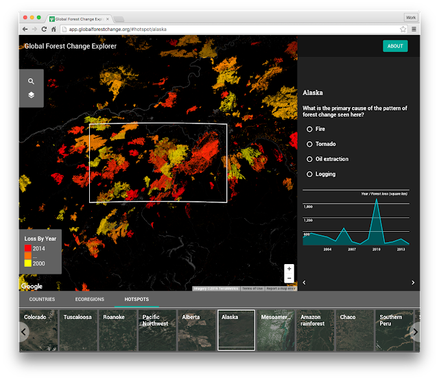
Forests are the mighty lungs of our planet. They absorb carbon dioxide, and emit oxygen on which all people and animals on Earth rely. For the sake of our future, it is critical that all people, including the next generation, understand our global forests in order to manage them sustainably. Today, Science in the Classroom, Dr. Matt Hansen of the University of Maryland, and Google Earth Engine are presenting Global Forest Change Explorer to help engage young people in forest conservation.
Tracking patterns of change in a hotspot zone, Alaska
The Global Forest Change Explorer website contains maps that are available for interactive analysis as well as an accompanying activity worksheet. The Explorer Tool allows students to quickly visualize trends in forest loss and gain, compare different countries and eco-regions, and apply the forest data to try to predict underlying causes where there is significant change in forest density. The Explorer Tool relies on open data that is used by remote sensing and GIS professionals in their work.
Fly to different parts of the world and compare data
A number of years ago, Dr. Matt Hansen and a team of researchers at the University of Maryland turned to Google Earth Engine to map high-resolution global forest cover with Earth Engine's cloud-based image processing and computing. The team mapped global forest loss and gain from 2000 to 2012 at 30-meter resolution for the entire globe. In 2013, the methods and results were published in Science Magazine and online for everyone to explore. These findings are now an important part of the website Global Forest Watch, which gives governments and decision makers free access to the data and tools required to monitor and manage their forests.
Dr. Matt Hansen presenting at the World Economic Forum
Science in the Classroom (SitC) thought this was great research to bring into the classroom and make available to anyone online. SitC packages annotated research papers with supplemental teaching materials to help pre-college and college students understand the structure and workings of scientific research. SitC and Google Earth Engine built the Global Forest Change Explorer to make Dr. Hansen’s data accessible to a younger audience.
Annotations provide supplemental context to Dr. Hansen's paper
We live in a dynamic world where the pressures of population growth increasingly impact and threaten our forests. However, as we continue to make advances in technology, we have better tools to research the health of our planet. Educators can easily flip their classrooms into science labs by combining SitC materials with Global Forest Change Explorer. With these tools, students will leave sessions with a richer understanding of environmental change, more curiosity, and a desire to actively participate in protecting our forests.

Get started with Global Forest Change Explorer today!

Get out and Explore what’s cooking in your local neighbourhood!


Canada’s neighbourhoods all have their own local foodie flair. And today, Google Maps is making it even easier for you to explore the best your city’s neighbourhoods have to offer with our updated Explore feature.

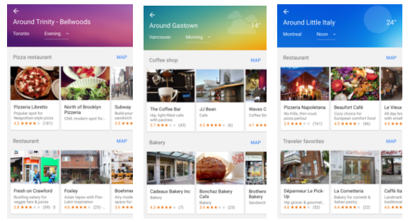
With just one tap, you can discover what is unique (and delicious!) about the neighbourhood you’re in - whether that’s an indie coffee shop in Gastown in Vancouver, a boulangerie in Montreal’s Outremont, or a taco joint in Kensington Market in Toronto.

It’s as easy as opening your Google Maps app, setting your location, and then tapping “Explore around you”. You can even tell your Maps app how far of a walk or a drive you’re willing to take, and what time of day you’re looking for.  The Maps app will give you a list of local spots to help you satisfy your craving or discover a new favourite.
     
The Explore feature is also great for when you’re visiting somewhere new - from New York to Tokyo, Maps is ready to help you uncover the best of what’s nearby.

Our phones are powerful pocket guides to the cities where we work, live, play and visit, with location-related mobile searches growing faster than all mobile searches. For example, Google search interest in “restaurants near me” has increased 26X since 2011, and Canadian search interest in “near me” has increased by 400% year-over-year from 2015 to 2016.

Whether you’re a tourist looking for a casual dinner or a local trying to find a new local watering hole, Google Maps for mobile provides the most detailed and useful information so you can make the best decision on where to go. After all, the best spot for a coffee on the go might not be the top pick for a place to linger and chat over biscotti with friends. With today’s Google Maps update, no matter the occasion — think Lunch nearby right now or Best spots for dinner with kids this weekend you can be confident that Google Maps has you covered.
Once you pick the category that suits your craving, you can see in-depth details about each location. Swipe through photos, get details (family-friendly? quick bite?), and check out ratings and reviews from Google and other diners. And for select spots, you also discover why it may be particularly relevant to you: for example, Google Maps may recommend a place that’s popular with other diners who visited a place you’ve been to in the past.
While Google Maps may offer a suggested list, such as lunch or dinner based on your location and time of day, sometimes a change of scenery is in order! Never fear, all options for nearby neighborhoods, categories and cuisines are all just one tap away. And if you don’t find the perfect place at first glance, you can choose to load more places from the area, expand the area or switch to a different category.
Happy Exploring!
Posted by Nicole Bell, Communications Manager, Google Canada

4 Things Small Businesses Should Know in A Mobile-First World

At the Google Performance Summit, we announced several new trends and product innovations that highlight mobile opportunities for advertisers. Here are the main takeaways for small businesses looking to make the most of the new mobile world:

1. Every year, there are trillions of searches on Google and over half of those searches happen on mobile.

More searches happen on mobile than on desktop computers – which is no surprise when we think about our own behavior as consumers. Throughout the day, whenever we want to buy, learn or go, we turn to our phones first.

2. Mobile is local. Nearly one third of all mobile searches are related to location, and that number is growing.

Whether they’re researching pizza delivery on Friday night or trying to find an orthodontist near their pre-teen’s middle school, consumers are using mobile to direct their actions in the local world. Thirty-two percent of consumers say that location-based search ads have led them to visit a store or make a purchase1. For small business serving customers in their area, mobile ads can offer a vital opportunity to connect with customers.

3. New local search ads help businesses bring customers right to their door.

As we announced at the Google Performance Summit, businesses using location extensions in AdWords can prominently display their business location when consumers search for things like “dentist” or “car repair shop near me” while on-the-go.

We’re also testing new local ad formats that make it easier for users to find businesses as they navigate on Google Maps. Consumers may start seeing experiments like promoted pins that allow businesses to strengthen their brand presence in maps.


4. AdWords is designed to help you succeed in a mobile-first world.

We also introduced innovations in both text and display ads to help AdWords work harder for you on smartphone screens. Look for these upgrades coming soon:

  • New expanded text ads in AdWords provide extra ad space so you can showcase more information about your products and services before the click. The key changes include more prominent headlines and a longer description line in your text ad.
  • Responsive ads for display will adapt to the diverse content, shapes and sizes of the more than two million publisher sites and apps on the Google Display Network. Just provide headlines, a description, an image, and a URL, and AdWords will create beautiful ads for you that looks good on every device and site.


To learn more about other exciting ads and analytics innovations announced at the Google Performance Summit, watch the livestream keynote here.


1. Google/Ipsos MediaCT/Purchased, Research: Understanding Consumers’ Local Search Behavior, May 2014

From Workshops to the Web: Small Business Week Lessons For Your Business

‘I love the idea of somebody Googling “Magnolia Abbey,” and being able to see my shop, and the interior, and know exactly where I am if they are local or coming through town,’ said Julianne Wall owner of Magnolia Abbey in Huntsville, AL. This National Small Business Week, Julianne was one of the many small business owners able to get her business on Google Search and Maps.

In celebration of National Small Business Week, Google and its local partner organizations hosted 888 free workshops helping 15,000 businesses from San Rafael, CA to Memphis, TN to Jersey City, NJ. Business owners learned about the benefits of adding photos to their listing, the changing landscape of mobile consumer behavior and how advertising online with Google can help them find new customers.
Last week, Google Agency Partners educated businesses about user trends and “The 10 Ways to Grow Your Business Online.” This interactive workshop was just one example of the hundreds held across the country for National Small Business Week.

National Small Business Week might be over, but there’s still an opportunity for businesses to attend workshops and access resources online. Google's Let’s Put Our Cities on the Map program works all year long to strengthen our communities by connecting businesses directly with local experts. Over 3,000 local partners host workshops and help businesses throughout the year to help them grow their business online. We also recently introduced online workshops so businesses can choose the lesson that’s right for them - whether it’s to learn how to get found on Google Search and Maps, get a custom email address, or promote their business with AdWords Express.

Google and our partners are #AllforSmallBiz and continuously support businesses in local communities, so it’s never too late to get your business online. Learn more at gybo.com/workshops.