Tag Archives: Google Earth

A new public energy tool to reduce emissions

Renewable energy, and the transition to a low-carbon future, has long been a priority for Google. However, there is still a long way to go toward the low-carbon future we envision.

Electricity generation from fossil fuels accounts for about 45 percent of global carbon emissions yet useful and accessible information to guide the transition to clean energy is still needed. Now with satellite data, cutting-edge science and powerful cloud computing technology like Google Earth Engine, we can achieve an unprecedented understanding of our changing environment and use that to guide wiser decision-making.

Today, the World Resources Institute (WRI) and Google, in partnership with leading global research institutions including Global Energy Observatory, KTH Royal Institute of Technology in Stockholm, and the University of Groningen, are releasing a global database of power plants. This database standardizes power sector information to encourage providers to adopt a common approach for reporting power plant features—like location, fuel type, and emissions—in the future.

Energy

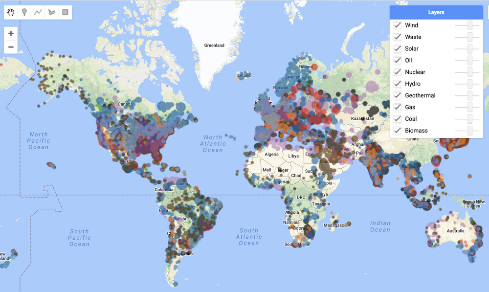
Global database of power plants 

Drawing from over 700 publicly available data sources, this database compiles information to cover 80 percent of globally installed electrical capacity from 168 countries, and includes capacity, generation rates, fuel type, ownership and location. Making this kind of information open and accessible to researchers and scientists can help reduce carbon emissions and increase energy access. Power capacity and generation indicators can be used to develop a more granular understanding of the emissions created from the electricity we use, and to develop pathways to decarbonize electricity supply.

Information about power plants—such as location and size—can help researchers study emissions and air pollution at an international, national, and local scale. And, as a high-quality geospatial data source, it can also be used to augment remote sensing and enable machine learning analysis to discover a wide variety of important environmental insights. The data is now available in Earth Engine and WRI’s Resource Watch, where it can be easily combined with other data to create new insights.

Until recently it wasn’t possible to monitor the health of Earth’s critical resources in both a globally consistent and locally relevant manner. Making global data openly available for researchers is a core mission of the Earth Outreach team. By working closely with on-the-ground partners we can put this data into the hands of those who can take action. With the increased visibility into the power sector that this database provides, we see the potential to make the transition to a low-carbon future happen even faster.

Take a walk on the wild side in Google Earth

This World Wildlife Day, become one with nature—and its animal inhabitants—on Voyager, Google Earth’s storytelling feature. We’ve launched three interactive tours with Explore.org, National Geographic Society and The Nature Conservancy that let you get up close with our planet’s magnificent animals and the challenges they face.

This live cam is owl you need

First, fly to the treetops of Montana with Explore.org to see owls and ospreys in the wild. You can watch live streams of three different owl species—Long-eared, Great Horned and Great Gray Owls — raising their young in their nests.

RaptorsOfMontana_OwlCam_GIF_1_Smaller_1.gif

All aboard

Hop on the National Geographic Photo Ark, an ambitious project from photographer Joel Sartore to document every species living in human care. Peek behind the scenes to see how Sartore captures these amazing shots, and don’t miss the last page for a choose-your-own-adventure look at 30 of the feathered, furry and finned friends that have already joined the Photo Ark.

up

Turtle power

Finally, dive into the South Pacific near the Arnavon Islands. Here you’ll find The Nature Conservancy and local communities working to protect the largest nesting site of the endangered hawksbill turtle.

SeaTurtleCam_GIF_1_Smaller_2.gif

The economic impact of geospatial services

With Google Maps, we’re committed to creating a rich, deep, and detailed understanding of the world. By digitizing and providing access to a wealth of information about the real world, we allow people to easily explore the world around them, provide tools for businesses to attract and connect with customers, power map and location experiences for third party apps and websites, and enable NGOs and governments to leverage our map and resources to tackle real-world challenges like urban planning or emergency response.

Google is continually looking for ways to add value––for our users, for local businesses, and for our partners across many industries. We want to stretch people’s perceptions of what a map can do for them, of the types of questions we can answer about the world, and the tasks we can help with. And to do that, we need to understand maps today and the impact they have on people’s lives.

With this in mind, we commissioned a detailed study to look at the impact of the geospatial industry—the ecosystem of industries that rely on geospatial technology (both online and offline)—and the direct benefit it provides to people, businesses and society. We worked with AlphaBeta, a strategy advisory business, to analyze the global impact of the geospatial industry in 2016. We asked AlphaBeta to highlight some of their findings and the methodology behind them. — Jen Fitzpatrick, VP Google Maps


At AlphaBeta, we’re passionate about identifying the forces shaping global markets and developing practical plans to create prosperity and well-being. We believe that geospatial technology is one of these forces, which is why we recently undertook research, commissioned by Google, to evaluate the impact of digital maps and their underlying technologies.

We asked ourselves: what is the full value of digital maps for users? How is this technology affecting the broader economic environment? How can societies make the most out of it?

We used consumer surveys across 22 countries spanning six regions, and other estimation approaches (such as big data analysis of online job postings), and found that geospatial services make an impact in three key ways:

Geospatial1

Consumer benefits
Maps help people move and shop in a faster and more efficient way. For example, not only do digital maps reduce travel time, they also help people save time on purchases by providing information like directions and product availability. By helping people plan routes in areas they aren’t familiar with, maps also improve public safety.

Geospatial2
Business benefits

Maps help make small and large businesses more visible, productive and profitable. By providing useful facts such as store hours, contact information and reviews, maps help drive sales—particularly important for small businesses that may find potential new customers without incurring additional advertising costs. Geospatial services also play a strategic role in helping companies in sectors covering approximately three quarters of the world’s GDP raise revenues and/or diminish costs. For example, retail companies use digital maps for market research and to identify the most profitable locations for their network of stores.

Geospatial3
Societal benefits

Finally, maps have positive spillover effects on the environment and societies around the world—for example, by creating jobs and reducing CO2 emissions through more efficient vehicle trips and easier identification of alternative transportation options. Geospatial technology can also play a role in emergencies—such as helping people prepare for a natural disaster by highlighting flood-risk areas.

The impact of geospatial services also varies from country to country—showing that there’s still room in many places to maximize the benefits of geospatial services for everyone. To do so, the geospatial industry, businesses, NGOs and governments in these areas will need to work together to promote, adopt and implement existing and new applications of geospatial technology.

To find out more, visit www.valueoftheweb.com.


Source: Google LatLong


The economic impact of geospatial services

With Google Maps, we’re committed to creating a rich, deep, and detailed understanding of the world. By digitizing and providing access to a wealth of information about the real world, we allow people to easily explore the world around them, provide tools for businesses to attract and connect with customers, power map and location experiences for third party apps and websites, and enable NGOs and governments to leverage our map and resources to tackle real-world challenges like urban planning or emergency response.

Google is continually looking for ways to add value––for our users, for local businesses, and for our partners across many industries. We want to stretch people’s perceptions of what a map can do for them, of the types of questions we can answer about the world, and the tasks we can help with. And to do that, we need to understand maps today and the impact they have on people’s lives.

With this in mind, we commissioned a detailed study to look at the impact of the geospatial industry—the ecosystem of industries that rely on geospatial technology (both online and offline)—and the direct benefit it provides to people, businesses and society. We worked with AlphaBeta, a strategy advisory business, to analyze the global impact of the geospatial industry in 2016. We asked AlphaBeta to highlight some of their findings and the methodology behind them. — Jen Fitzpatrick, VP Google Maps


At AlphaBeta, we’re passionate about identifying the forces shaping global markets and developing practical plans to create prosperity and well-being. We believe that geospatial technology is one of these forces, which is why we recently undertook research, commissioned by Google, to evaluate the impact of digital maps and their underlying technologies.

We asked ourselves: what is the full value of digital maps for users? How is this technology affecting the broader economic environment? How can societies make the most out of it?

We used consumer surveys across 22 countries spanning six regions, and other estimation approaches (such as big data analysis of online job postings), and found that geospatial services make an impact in three key ways:

Geospatial1

Consumer benefits
Maps help people move and shop in a faster and more efficient way. For example, not only do digital maps reduce travel time, they also help people save time on purchases by providing information like directions and product availability. By helping people plan routes in areas they aren’t familiar with, maps also improve public safety.

Geospatial2
Business benefits

Maps help make small and large businesses more visible, productive and profitable. By providing useful facts such as store hours, contact information and reviews, maps help drive sales—particularly important for small businesses that may find potential new customers without incurring additional advertising costs. Geospatial services also play a strategic role in helping companies in sectors covering approximately three quarters of the world’s GDP raise revenues and/or diminish costs. For example, retail companies use digital maps for market research and to identify the most profitable locations for their network of stores.

Geospatial3
Societal benefits

Finally, maps have positive spillover effects on the environment and societies around the world—for example, by creating jobs and reducing CO2 emissions through more efficient vehicle trips and easier identification of alternative transportation options. Geospatial technology can also play a role in emergencies—such as helping people prepare for a natural disaster by highlighting flood-risk areas.

The impact of geospatial services also varies from country to country—showing that there’s still room in many places to maximize the benefits of geospatial services for everyone. To do so, the geospatial industry, businesses, NGOs and governments in these areas will need to work together to promote, adopt and implement existing and new applications of geospatial technology.

To find out more, visit www.valueoftheweb.com.


View the world through someone else’s lens in Google Earth

Every day, hundreds of millions of people are snapping photos of the world around them. What if you could explore the world through the eyes of all those people? Starting today you're invited to explore a global map of crowdsourced photos in Google Earth. Take a walk around Shinto shrines or hang out on a beach in Bora Bora—wherever you look, you're bound to find a unique perspective on the world.

To get started, open the Google Earth app on Android and iOS, or go to Google Earth in your Chrome browser on desktop. Open the main menu and turn on the Photos toggle. As you explore the world and zoom in, relevant photos from each location will appear. Click on any thumbnail to see a full-screen version of the photo, and then flip through related photos.

photos in Earth

To build this new experience, we used finely-tuned machine learning to pull the most beautiful and interesting photos from the millions and millions already shared in Google Maps by Local Guides and other contributors. This means that you can add your own great photos—and if you've already posted some, start looking for your photos in Earth.

Whether you're looking for travel inspiration, preparing a geography report for school, or simply taking flight from the comfort of your couch, the new Photos layer gives you the ability to look at far off places up close. And with new photos being added every day, there's a great reason to keep coming back for more.

Turn around, bright eyes… and experience the total solar eclipse with Google

Move over, blue moon—there’s a more rare astronomical event in town. For the first time since 1979, a total eclipse of the sun is coming to the continental United States this Monday, August 21. Starting on the west coast around 9 a.m., the moon will begin to block the face of the sun. Not long later, the moon will completely cover the sun, leaving only the bright corona visible for as long as two minutes and 40 seconds.

Whether you’re traveling to see the “totality,” catching a glimpse of the partial eclipse from another location, or simply curious, Google can help you learn more about this unique moment. Grab your solar glasses and peep what we’ve got in store:

Live from the solar eclipse

Even if you’re not in the path of the solar eclipse you can tune to YouTube to watch the magic unfold live as it crosses over the U.S. Catch livestreams from NASA, The Weather Channel, Exploratorium, Discovery's Science Channel, and Univision.

Sun, moon and Google Earth

With a new Voyager story in Google Earth, you can learn more about the science behind the eclipse. You can also see what it will look like where you live.

Futures made of virtual totality

If you’re not in 70 mile wide path of totality, fret not. Travel to Mt. Jefferson, OR in Google Earth VR (on Rift and Vive) and view it in virtual reality. From the menu, select Total Solar Eclipse to get a view from the center of the action.

Lights, camera, astronomical action

We’re working with UC Berkeley, other partners and volunteer photographers to capture images of the sun’s corona at the moment of totality for use in scientific research. We’re also using our technology to algorithmically align these images into the Eclipse Megamovie, a continuous view of the eclipse. Read about some of the people involved in this project, and stay tuned for the complete Megamovie soon after the eclipse on https://eclipsemega.movie.

It’s a bird, it’s a plane, it’s Android O!

People worldwide have explained solar eclipses through the lens of myth and legend for centuries. This year, there’s a new supernatural being whose identity will be revealed as the sun and the moon do their celestial dance. Get ready to meet Android O at android.com/o.

While a solar eclipse is a pretty rare astronomical event, don’t worry it’s not too early to start planning for the next one passing over the United States on October 14, 2023. You can always set a Google Calendar reminder to make sure you don’t forget.

Source: Android


Turn around, bright eyes… and experience the total solar eclipse with Google

Move over, blue moon—there’s a more rare astronomical event in town. For the first time since 1979, a total eclipse of the sun is coming to the continental United States this Monday, August 21. Starting on the west coast around 9 a.m., the moon will begin to block the face of the sun. Not long later, the moon will completely cover the sun, leaving only the bright corona visible for as long as two minutes and 40 seconds.

Whether you’re traveling to see the “totality,” catching a glimpse of the partial eclipse from another location, or simply curious, Google can help you learn more about this unique moment. Grab your solar glasses and peep what we’ve got in store:

Live from the solar eclipse

Even if you’re not in the path of the solar eclipse you can tune to YouTube to watch the magic unfold live as it crosses over the U.S. Catch livestreams from NASA, The Weather Channel, Exploratorium, Discovery's Science Channel, and Univision.

Sun, moon and Google Earth

With a new Voyager story in Google Earth, you can learn more about the science behind the eclipse. You can also see what it will look like where you live.

Futures made of virtual totality

If you’re not in 70 mile wide path of totality, fret not. Travel to Mt. Jefferson, OR in Google Earth VR (on Rift and Vive) and view it in virtual reality. From the menu, select Total Solar Eclipse to get a view from the center of the action.

Lights, camera, astronomical action

We’re working with UC Berkeley, other partners and volunteer photographers to capture images of the sun’s corona at the moment of totality for use in scientific research. We’re also using our technology to algorithmically align these images into the Eclipse Megamovie, a continuous view of the eclipse. Read about some of the people involved in this project, and stay tuned for the complete Megamovie soon after the eclipse on https://eclipsemega.movie.

It’s a bird, it’s a plane, it’s Android O!

People worldwide have explained solar eclipses through the lens of myth and legend for centuries. This year, there’s a new supernatural being whose identity will be revealed as the sun and the moon do their celestial dance. Get ready to meet Android O at android.com/o.

While a solar eclipse is a pretty rare astrological event, don’t worry it’s not too early to start planning for the next one passing over the United States on October 14, 2023. You can always set a Google Calendar reminder to make sure you don’t forget.

Source: Android


Turn around, bright eyes… and experience the total solar eclipse with Google

Move over, blue moon—there’s a more rare astronomical event in town. For the first time since 1979, a total eclipse of the sun is coming to the continental United States this Monday, August 21. Starting on the west coast around 9 a.m., the moon will begin to block the face of the sun. Not long later, the moon will completely cover the sun, leaving only the bright corona visible for as long as two minutes and 40 seconds.

Whether you’re traveling to see the “totality,” catching a glimpse of the partial eclipse from another location, or simply curious, Google can help you learn more about this unique moment. Grab your solar glasses and peep what we’ve got in store:

Live from the solar eclipse

Even if you’re not in the path of the solar eclipse you can tune to YouTube to watch the magic unfold live as it crosses over the U.S. Catch livestreams from NASA, The Weather Channel, Exploratorium, Discovery's Science Channel, and Univision.

Sun, moon and Google Earth

With a new Voyager story in Google Earth, you can learn more about the science behind the eclipse. You can also see what it will look like where you live.

Futures made of virtual totality

If you’re not in 70 mile wide path of totality, fret not. Travel to Mt. Jefferson, OR in Google Earth VR (on Rift and Vive) and view it in virtual reality. From the menu, select Total Solar Eclipse to get a view from the center of the action.

Lights, camera, astronomical action

We’re working with UC Berkeley, other partners and volunteer photographers to capture images of the sun’s corona at the moment of totality for use in scientific research. We’re also using our technology to algorithmically align these images into the Eclipse Megamovie, a continuous view of the eclipse. Read about some of the people involved in this project, and stay tuned for the complete Megamovie soon after the eclipse on https://eclipsemega.movie.

It’s a bird, it’s a plane, it’s Android O!

People worldwide have explained solar eclipses through the lens of myth and legend for centuries. This year, there’s a new supernatural being whose identity will be revealed as the sun and the moon do their celestial dance. Get ready to meet Android O at android.com/o.

While a solar eclipse is a pretty rare astronomical event, don’t worry it’s not too early to start planning for the next one passing over the United States on October 14, 2023. You can always set a Google Calendar reminder to make sure you don’t forget.

Source: Android


Turn around, bright eyes… and experience the total solar eclipse with Google

Move over, blue moon—there’s a more rare astronomical event in town. For the first time since 1979, a total eclipse of the sun is coming to the continental United States this Monday, August 21. Starting on the west coast around 9 a.m., the moon will begin to block the face of the sun. Not long later, the moon will completely cover the sun, leaving only the bright corona visible for as long as two minutes and 40 seconds.

Whether you’re traveling to see the “totality,” catching a glimpse of the partial eclipse from another location, or simply curious, Google can help you learn more about this unique moment. Grab your solar glasses and peep what we’ve got in store:

Live from the solar eclipse

Even if you’re not in the path of the solar eclipse you can tune to YouTube to watch the magic unfold live as it crosses over the U.S. Catch livestreams from NASA, The Weather Channel, Exploratorium, Discovery's Science Channel, and Univision.

Sun, moon and Google Earth

With a new Voyager story in Google Earth, you can learn more about the science behind the eclipse. You can also see what it will look like where you live.

Futures made of virtual totality

If you’re not in 70 mile wide path of totality, fret not. Travel to Mt. Jefferson, OR in Google Earth VR (on Rift and Vive) and view it in virtual reality. From the menu, select Total Solar Eclipse to get a view from the center of the action.

Lights, camera, astronomical action

We’re working with UC Berkeley, other partners and volunteer photographers to capture images of the sun’s corona at the moment of totality for use in scientific research. We’re also using our technology to algorithmically align these images into the Eclipse Megamovie, a continuous view of the eclipse. Read about some of the people involved in this project, and stay tuned for the complete Megamovie soon after the eclipse on https://eclipsemega.movie.

It’s a bird, it’s a plane, it’s Android O!

People worldwide have explained solar eclipses through the lens of myth and legend for centuries. This year, there’s a new supernatural being whose identity will be revealed as the sun and the moon do their celestial dance. Get ready to meet Android O at android.com/o.

While a solar eclipse is a pretty rare astronomical event, don’t worry it’s not too early to start planning for the next one passing over the United States on October 14, 2023. You can always set a Google Calendar reminder to make sure you don’t forget.

Source: Search


There’s no place like home, in Google Earth

When you opened Google Earth for the very first time, where did you go? For most people there's a common destination: Home. The definition of "home" changes by country, culture and climate. So as part of the relaunch of Google Earth back in April, we introduced This is Home, an interactive tour to five traditional homes around the world. You could step inside the colorful home of Kancha Sherpa in Nepal, or head to the desert and learn how an extended drought changed the lives of the Bedouin people.


Since then, we’ve traveled to dozens more homes across six continents and today we’re bringing 22 new homes and cultures to explore in Google Earth.
Kenya
This is Ngaramat Loongito, Kenya, home to a Maasai community. Photo courtesy of Maasai Wilderness Conservation Trust

Start with a Torajan home, built to withstand Indonesia’s wet season. Then head to Fujian Province, China, to peek inside the immense walls the Hakka people built to keep away bandits, beasts and warlords. See the shape-shifting yurt homes Mongolian country-dwellers use to move where their herds roam. Visit a village on Madagascar’s southwest coast where the Vezo people live off the third largest coral reef system in the world. Finally, see how a Paiwan shaman has integrated her spirituality into the walls of her home in Taiwan.

Splash

To tell these stories, we worked with partners and communities to digitally preserve homes of different cultures in Street View. Many of these homes belong to indigenous people, such as The Garasia people of India, the Chatino people of Mexico, the Torajan people of Indonesia, and the Māori people of New Zealand. Their homes represent their unique cultural identity and ways of relating to the environment.


Some of the images and stories provide a snapshot in time of cultures, who face economic, environmental and population pressures. For example, the Inuit people of Sanikiluaq have been building igloos for schoolchildren to learn in for decades, but in recent winters, conditions haven’t been cold enough to create the right type of snow. It’s important to document these lifestyles now, because some may be disappearing.

Thank you to the families who shared their homes, their customs and their culture with the world!