Tag Archives: Geo

Making the most of the Google Maps Web Service APIs

When it comes to app development, there can be a disconnect between the robust app we intended to build and the code we actually get into a minimum viable product. These shortcuts end up causing error conditions once under load in production.

The Google Maps API team maintains client libraries that give you the power to develop with the confidence that your app will scale smoothly. We provide client libraries for Python, Java, and Go, which are used by thousands of developers around the world. We're excited to announce the recent addition of Node.js to the client library family.

When building mobile applications, it is a best practice to use native APIS like Places API for Android and Places API for iOS where you can, but when you find that your use case requires data that is only available via the Google Maps APIs Web Services, such as Elevation, then using these client libraries is the best way forward.

These libraries help you implement API request best practices such as:
  • Requests are sent at the default rate limit for each web service, but of course this is configurable.
  • The client libraries will automatically retry any request if the API sends a 5xx error. Retries use exponential back-off, which helps in the event of intermittent failures.
  • The client libraries make it easy to authenticate with your freely available API Key. Google Maps APIs Premium Plan customers can alternatively use their client ID and secret.
  • The Java and Go libraries return native objects for each of the API responses. The Python and Node.js libraries return the structure as it is received from the API.
The client libraries can help you in a variety of ways. One of them is exposing the result sets in a format that makes most sense for the language in question. For example, the Java and Go client libraries include object hierarchies that are type-safe representations of the potential results for each API. This allows you to write code in the comfort of your editor with the knowledge that the compiler will catch any mistakes.

With 3 million apps and websites using Google Maps APIs, we have an important tip for ensuring reliability when using web services: call APIs from a server rather than directly from Android or iOS. This secures your API key so that your quota can't be consumed by a bad actor, along with being able to add caching to handle common requests quickly.

A server instance acts as a proxy that takes requests from your Android and iOS apps and then forwards them to the Google Maps Web Service APIs on your app’s behalf. The easiest way to create a server side proxy is using the Google Maps Web Service client libraries from Google App Engine instances. For more detail, please watch Laurence Moroney’s Google I/O 2016 session “Building geo services that scale”.

You can learn more about the Google Maps API web services in our documentation. The easiest way to use these APIs and follow best practices is to use the Client Libraries for Google Maps Web Services. Download the client libraries for Java, Python, Go or Node.js from Github to start using them today!

author image
Posted by Brett Morgan, Developer Programs Engineer

New JavaScript Street View renderer brings rendering improvements and better mobile support

Street View is one of Google Maps’ most loved features, providing users with a way to explore and experience the world around them. Developers all over the world use Street View in the Google Maps JavaScript API to make their apps more unique and exciting, giving their users a sense of what it’s like to visit a place in real life.


Today we’re making Street View even better, especially on mobile devices, by launching a new Street View renderer in the Google Maps JavaScript API. Read on for the full details of what we’ve improved!


Better display


Smoother Transitions


Transitions from one point to another in Street View now include more animation frames, creating the effect of gliding smoothly to the next location. Transitions in the old renderer looked like jumping from one location to another.


Old renderer


New renderer

next-old-short.gifnext-new-short.gif


Smoother Loading Animations


The old renderer repeats images while loading new content, resulting in a stuttering effect. The new renderer uses lower resolution imagery while loading, resulting in a smoother animation when rotating an image in Street View.


Old renderer


New renderer


old.gif


new.gif


Object modeling improvements


Objects in Street View look better in the new renderer because it builds a 360-degree model that considers all possible perspectives. For example, this high rise building has wavy lines in the old renderer, as opposed to crisp lines in the new renderer.


Old renderer


New renderer


In another example: for imagery on an incline, such as a street with a steep hill, the new renderer corrects the objects to be vertical, whereas the old renderer would have shown the objects at an angle.


Old renderer


New renderer


Better mobile support


WebGL imagery


The new renderer uses WebGL (on browsers that support it) which results in a higher frame rate and better rendering, especially on mobile devices. On mobile devices, the old renderer would display a fish-eye projection of the image, whereas WebGL allows us to present a rendered sphere that looks as it would in reality. For example, the street in the image below is straight, but the old renderer made it look curved on mobile devices.


Old renderer


New renderer


WebGL_before.png


WebGL_after.png


Touch support


As mobile web usage grows, users expect familiar touch-based interactions to work everywhere. The new renderer supports the same natural touch-based gestures on mobile which have been available in the Google Maps Android app: pinch-to-zoom and double-tap-to-go. In the old renderer, zooming was only available through the +/- buttons, and movement was only possible by clicking the arrows on the ground.


Motion tracking on mobile devices


Mobile devices give developers the opportunity to provide their users with more natural ways to explore and interact with their applications. We’ve enabled support for device orientation events on Street View so that users on mobile devices can look around in Street View by moving their phone. Developers have the option to turn this off if they prefer. Please see the developer documentation for more details, or open the documentation link on a mobile device to see motion tracking in action.


Better controls


X Forward


When using a desktop device with a mouse or trackpad, users will see a small "X" at the cursor location that indicates the next camera location if they choose to move forward. Arrows indicate the direction of movement. Wall rectangles identify the direction the camera will point towards.


Next image targets


Next centered image target


Cleaner street names, labels and targets


Street names and labels are now separated from controls, removing overlap issues and allowing for clean display in right-to-left and left-to-right languages.


Old renderer


New renderer


We hope you enjoy using the new and improved Street View renderer! Also a big thank you to all the developers who use the Google Maps JavaScript API and provide feedback via the issue tracker. Getting feedback from developers is vital for us to be able to keep improving our products, so if you have any bug reports or feature requests, please let us know!


For more information on Street View in the Google Maps JavaScript API, please see the developer documentation.


author image

Posted by Elena Kelareva, Product Manager, Google Maps APIs


New JavaScript Street View renderer brings rendering improvements and better mobile support

Street View is one of Google Maps’ most loved features, providing users with a way to explore and experience the world around them. Developers all over the world use Street View in the Google Maps JavaScript API to make their apps more unique and exciting, giving their users a sense of what it’s like to visit a place in real life.

Today we’re making Street View even better, especially on mobile devices, by launching a new Street View renderer in the Google Maps JavaScript API. Read on for the full details of what we’ve improved!

Better display

Smoother Transitions

Transitions from one point to another in Street View now include more animation frames, creating the effect of gliding smoothly to the next location. Transitions in the old renderer looked like jumping from one location to another.

Old renderer
New renderer
next-old-short.gifnext-new-short.gif

Smoother Loading Animations

The old renderer repeats images while loading new content, resulting in a stuttering effect. The new renderer uses lower resolution imagery while loading, resulting in a smoother animation when rotating an image in Street View.

Old renderer
New renderer
old.gif
new.gif

Object modeling improvements

Objects in Street View look better in the new renderer because it builds a 360-degree model that considers all possible perspectives. For example, this high rise building has wavy lines in the old renderer, as opposed to crisp lines in the new renderer.

Old renderer
New renderer

In another example: for imagery on an incline, such as a street with a steep hill, the new renderer corrects the objects to be vertical, whereas the old renderer would have shown the objects at an angle.

Old renderer
New renderer

Better mobile support

WebGL imagery

The new renderer uses WebGL (on browsers that support it) which results in a higher frame rate and better rendering, especially on mobile devices. On mobile devices, the old renderer would display a fish-eye projection of the image, whereas WebGL allows us to present a rendered sphere that looks as it would in reality. For example, the street in the image below is straight, but the old renderer made it look curved on mobile devices.

Old renderer
New renderer
WebGL_before.png
WebGL_after.png

Touch support

As mobile web usage grows, users expect familiar touch-based interactions to work everywhere. The new renderer supports the same natural touch-based gestures on mobile which have been available in the Google Maps Android app: pinch-to-zoom and double-tap-to-go. In the old renderer, zooming was only available through the +/- buttons, and movement was only possible by clicking the arrows on the ground.

Motion tracking on mobile devices

Mobile devices give developers the opportunity to provide their users with more natural ways to explore and interact with their applications. We’ve enabled support for device orientation events on Street View so that users on mobile devices can look around in Street View by moving their phone. Developers have the option to turn this off if they prefer. Please see the developer documentation for more details, or open the documentation link on a mobile device to see motion tracking in action.

Better controls

X Forward

When using a desktop device with a mouse or trackpad, users will see a small "X" at the cursor location that indicates the next camera location if they choose to move forward. Arrows indicate the direction of movement. Wall rectangles identify the direction the camera will point towards.

Next image targets
Next centered image target

Cleaner street names, labels and targets

Street names and labels are now separated from controls, removing overlap issues and allowing for clean display in right-to-left and left-to-right languages.

Old renderer
New renderer
We hope you enjoy using the new and improved Street View renderer! Also a big thank you to all the developers who use the Google Maps JavaScript API and provide feedback via the issue tracker. Getting feedback from developers is vital for us to be able to keep improving our products, so if you have any bug reports or feature requests, please let us know!

For more information on Street View in the Google Maps JavaScript API, please see the developer documentation.

author image
Posted by Elena Kelareva, Product Manager, Google Maps APIs

Keep users focused on what’s important with the latest Google Maps Android API

Released today, the latest version of the Google Maps Android API includes more developer requested features: you can now track camera movements more accurately via our new camera listeners, set the minimum & maximum zoom levels on your map, and restrict the user’s panning to particular lat/lng bounds of the camera target. In addition, we’ve added a new marker Tag property so you can now associate your own data object with a marker.

Track camera movements more accurately

As one of our top requests, developers have been asking for a better way to track camera movements and the ability to see why the camera is moving, whether caused by user gestures, built-in API animations or developer controlled movements [Issue 4636]. Our new camera change listeners support you in doing this. Your app can now receive notifications for camera start, ongoing, and end events.

See the developer’s guide to camera change events and take a look at this code sample which shows you how to detect when the user drags the map, and draws a line to track this movement when it happens.

Control the zooming, panning and scrolling experience

Have you ever wanted to be able to control how much your user can zoom in and out and pan around on your map so that you can more tightly control the experience? Or have you got tile overlays only for zoom levels 15 through 20 and wish you could limit the zooming capability of both the map and your tile overlays to those particular levels?

You can now set the min and max zoom levels on your map by using GoogleMap.setMinZoomPreference() and GoogleMap.setMaxZoomPreference() [Issue 4663]. These zoom levels will also apply to any tile overlays you have on your map.

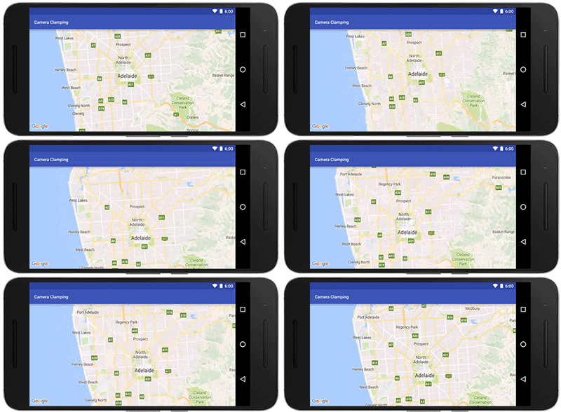
In addition, you can also constrain the lat/lng center bounds of the focal point of the map (the camera target) so that users can only scroll and pan within these bounds using GoogleMap.setLatLngBoundsForCameraTarget(). This is awesome if you want your users to stay within the map area of your tile overlays, or you wish to confine the map in your app to a particular local area.
Pan and zoom limits on a map for Adelaide, a beautiful city in South Australia
See the developer’s guide to learn more about setting boundaries on the map as well as this code sample.

Marker tags

Does your app cater for different types of markers and you want to treat them differently when a user taps on them? Or do you want to assign priorities to your markers? The new marker Tag property allows you to associate whatever data object you like with a marker, supporting you in doing this and more [Issue 4650].

A big thank you to Android developers everywhere for using the Google Maps Android API and submitting feedback via the issue tracker.

Our release notes contain details of bugs fixed as well as the features mentioned in this post. Take a look and start using our new features today!
author image Posted by Megan Boundey, Product Manager, Google Maps Mobile APIs


Keep users focused on what’s important with the latest Google Maps Android API

Released today, the latest version of the Google Maps Android API includes more developer requested features: you can now track camera movements more accurately via our new camera listeners, set the minimum & maximum zoom levels on your map, and restrict the user’s panning to particular lat/lng bounds of the camera target. In addition, we’ve added a new marker Tag property so you can now associate your own data object with a marker.


Track camera movements more accurately


As one of our top requests, developers have been asking for a better way to track camera movements and the ability to see why the camera is moving, whether caused by user gestures, built-in API animations or developer controlled movements [Issue 4636]. Our new camera change listeners support you in doing this. Your app can now receive notifications for camera start, ongoing, and end events.


See the developer’s guide to camera change events and take a look at this code sample which shows you how to detect when the user drags the map, and draws a line to track this movement when it happens.


Control the zooming, panning and scrolling experience


Have you ever wanted to be able to control how much your user can zoom in and out and pan around on your map so that you can more tightly control the experience? Or have you got tile overlays only for zoom levels 15 through 20 and wish you could limit the zooming capability of both the map and your tile overlays to those particular levels?


You can now set the min and max zoom levels on your map by using GoogleMap.setMinZoomPreference() and GoogleMap.setMaxZoomPreference() [Issue 4663]. These zoom levels will also apply to any tile overlays you have on your map.


In addition, you can also constrain the lat/lng center bounds of the focal point of the map (the camera target) so that users can only scroll and pan within these bounds using GoogleMap.setLatLngBoundsForCameraTarget(). This is awesome if you want your users to stay within the map area of your tile overlays, or you wish to confine the map in your app to a particular local area.


Pan and zoom limits on a map for Adelaide, a beautiful city in South Australia


See the developer’s guide to learn more about setting boundaries on the map as well as this code sample.


Marker tags


Does your app cater for different types of markers and you want to treat them differently when a user taps on them? Or do you want to assign priorities to your markers? The new marker Tag property allows you to associate whatever data object you like with a marker, supporting you in doing this and more [Issue 4650].


A big thank you to Android developers everywhere for using the Google Maps Android API and submitting feedback via the issue tracker.


Our release notes contain details of bugs fixed as well as the features mentioned in this post. Take a look and start using our new features today!


author image Posted by Megan Boundey, Product Manager, Google Maps Mobile APIs


Google Places API for iOS & Google Maps SDK for iOS are now in separate CocoaPods

In today’s release, the Google Places API for iOS 2.0 and the Google Maps SDK for iOS 2.0 are now in separate CocoaPods. For developers who only use the Google Places API for iOS, this will significantly reduce the binary size of their app.

What does this mean for me? What do I have to do?

Nothing immediately for your current implementation, but we strongly suggest that you upgrade within the next year to the new Google Maps SDK for iOS 2.0 and Google Places API for iOS 2.0. The Google Maps for iOS SDK Version 1.x will become unsupported in one year’s time.

If you are using the Standard Plan Google Maps SDK for iOS 1.x, and haven’t specified a version in your podfile, you will be automatically upgraded to the new Google Maps SDK for iOS 2.0 when you run ‘pod update’. If you use any Places functionality, we’ve created this migration guide for the Places API to step you through the process of migrating to the new Google Places API for iOS 2.0.

In addition, we’ve documented how to extract all the frameworks (Maps, Places) from the relevant CocoaPods so you can manually include the SDKs in your project rather than using CocoaPods if you wish. [Issue 8856]

What does this mean for Premium Plan Maps SDK customers?

There is no longer a separate Google Maps Premium Plan SDK. Instead it has been replaced with the new streamlined Google Maps SDK for iOS 2.0 for both Standard and Premium Plan developers.

We’ve created a Premium Plan migration guide that will step you through the process of migrating to the new Google Maps SDK for iOS 2.0. We’ve also documented how to extract the frameworks from the CocoaPods so you can manually include the SDKs in your project if you’d prefer that. Your Enterprise Maps key will continue to work, as will your Premium Plan.

Please note:
The Google Maps SDK for iOS Premium Plan SDK 1.13.2 (current version) will be supported for one year during which time we suggest you upgrade to the new streamlined Google Maps SDK for iOS 2.0.

Take a look at our release notes and start using version 2.0 today!

author image
Posted by Megan Boundey, Product Manager, Google Maps Mobile APIs

Google Places API for iOS & Google Maps SDK for iOS are now in separate CocoaPods

In today’s release, the Google Places API for iOS 2.0 and the Google Maps SDK for iOS 2.0 are now in separate CocoaPods. For developers who only use the Google Places API for iOS, this will significantly reduce the binary size of their app.


What does this mean for me? What do I have to do?


Nothing immediately for your current implementation, but we strongly suggest that you upgrade within the next year to the new Google Maps SDK for iOS 2.0 and Google Places API for iOS 2.0. The Google Maps for iOS SDK Version 1.x will become unsupported in one year’s time.


If you are using the Standard Plan Google Maps SDK for iOS 1.x, and haven’t specified a version in your podfile, you will be automatically upgraded to the new Google Maps SDK for iOS 2.0 when you run ‘pod update’. If you use any Places functionality, we’ve created this migration guide for the Places API to step you through the process of migrating to the new Google Places API for iOS 2.0.


In addition, we’ve documented how to extract all the frameworks (Maps, Places) from the relevant CocoaPods so you can manually include the SDKs in your project rather than using CocoaPods if you wish. [Issue 8856]


What does this mean for Premium Plan Maps SDK customers?


There is no longer a separate Google Maps Premium Plan SDK. Instead it has been replaced with the new streamlined Google Maps SDK for iOS 2.0 for both Standard and Premium Plan developers.


We’ve created a Premium Plan migration guide that will step you through the process of migrating to the new Google Maps SDK for iOS 2.0. We’ve also documented how to extract the frameworks from the CocoaPods so you can manually include the SDKs in your project if you’d prefer that. Your Enterprise Maps key will continue to work, as will your Premium Plan.


Please note:

The Google Maps SDK for iOS Premium Plan SDK 1.13.2 (current version) will be supported for one year during which time we suggest you upgrade to the new streamlined Google Maps SDK for iOS 2.0.


Take a look at our release notes and start using version 2.0 today!


author image

Posted by Megan Boundey, Product Manager, Google Maps Mobile APIs

I/O session: Location and Proximity Superpowers: Eddystone + Google Beacon Platform

Bluetooth beacons mark important places and objects in a way that your phone understands. Last year, we introduced the Google beacon platform including Eddystone, Nearby Messages and the Proximity Beacon API that helps developers build beacon-powered proximity and location features in their apps.

Since then, we’ve learned that when deployment of physical infrastructure is involved, it’s important to get the best possible value from your investment. That’s why the Google beacon platform works differently from the traditional approach.

We don’t think of beacons as only pointing to a single feature in an app, or a single web resource. Instead, the Google beacon platform enables extensible location infrastructure that you can manage through your Google Developer project and reuse many times. Each beacon can take part in several different interactions: through your app, through other developers’ apps, through Google services, and the web. All of this functionality works transparently across Eddystone-UID and Eddystone-EID -- because using our APIs means you never have to think about monitoring for the individual bytes that a beacon is broadcasting.

For example, we’re excited that the City of Amsterdam has adopted Eddystone and the newly released publicly visible namespace feature for the foundation of their open beacon network. Or, through Nearby Notifications, Eddystone and the Google beacon platform enable explorers of the BFG Dream Jar Trail to discover cloud-updateable content in Dream Jars across London.

To make getting started as easy as possible we’ve provided a set of tools to help developers, including links to beacon manufacturers that can help you with Eddystone, Beacon Tools (for Android and iOS), the Beacon Dashboard, a codelab and of course our documentation. And, if you were not able to attend Google I/O in person this year, you can watch my session, Location and Proximity Superpowers: Eddystone + Google Beacon Platform:
We can’t wait to see what you build!

author image
About Peter: I am a Product Manager for the Google beacon platform, including the open beacon format Eddystone, and Google's cloud services that integrate beacon technology with first and third party apps. When I’m not working at Google I enjoy taking my dog, Oscar, for walks on Hampstead Heath.

I/O session: Location and Proximity Superpowers: Eddystone + Google Beacon Platform

Bluetooth beacons mark important places and objects in a way that your phone understands. Last year, we introduced the Google beacon platform including Eddystone, Nearby Messages and the Proximity Beacon API that helps developers build beacon-powered proximity and location features in their apps.

Since then, we’ve learned that when deployment of physical infrastructure is involved, it’s important to get the best possible value from your investment. That’s why the Google beacon platform works differently from the traditional approach.

We don’t think of beacons as only pointing to a single feature in an app, or a single web resource. Instead, the Google beacon platform enables extensible location infrastructure that you can manage through your Google Developer project and reuse many times. Each beacon can take part in several different interactions: through your app, through other developers’ apps, through Google services, and the web. All of this functionality works transparently across Eddystone-UID and Eddystone-EID — because using our APIs means you never have to think about monitoring for the individual bytes that a beacon is broadcasting.

For example, we’re excited that the City of Amsterdam has adopted Eddystone and the newly released publicly visible namespace feature for the foundation of their open beacon network. Or, through Nearby Notifications, Eddystone and the Google beacon platform enable explorers of the BFG Dream Jar Trail to discover cloud-updateable content in Dream Jars across London.

To make getting started as easy as possible we’ve provided a set of tools to help developers, including links to beacon manufacturers that can help you with Eddystone, Beacon Tools (for Android and iOS), the Beacon Dashboard, a codelab and of course our documentation. And, if you were not able to attend Google I/O in person this year, you can watch my session, Location and Proximity Superpowers: Eddystone + Google Beacon Platform:

We can’t wait to see what you build!

author image

About Peter: I am a Product Manager for the Google beacon platform, including the open beacon format Eddystone, and Google’s cloud services that integrate beacon technology with first and third party apps. When I’m not working at Google I enjoy taking my dog, Oscar, for walks on Hampstead Heath.

Announcing marker clustering in the Google Maps SDK for iOS Utility Library

Today we’ve added marker clustering to the Google Maps SDK for iOS Utility Library! This much-requested feature is now available for iOS in addition to Android and JavaScript.

Do you ever feel that your map just has too many markers on it, making it feel cluttered and hard to comprehend? Or, perhaps you want to show where the popular restaurants are in your city, but you still want your map to look clean?

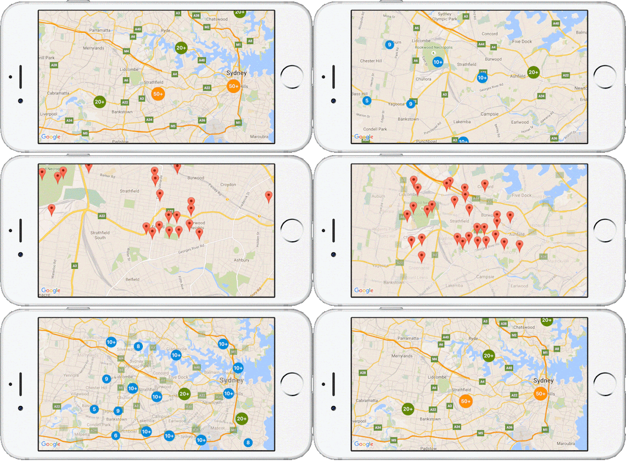
Marker clustering supports you in doing this. As the zoom levels of the map change, you can aggregate markers, indicating clearly to your users exactly where those popular restaurants are located. As your user zooms in, the markers progressively split out until all of the individual markers are displayed.
Using the new marker clustering feature in the Google Maps SDK for iOS Utility Library is an easy 4 step process:
  • Add ‘Google-Maps-iOS-Utils’ to your Podfile
  • Instantiate the GMUClusterManager
  • Implement the GMUClusterItem protocol for your marker objects
  • Add the marker objects to the cluster manager
We provide the default algorithm, renderer and icon generator to support you in doing this. In addition, you can also fully customize each of these by extending the default implementations, or by providing your own implementation of these protocols: GMUClusterAlgorithm, GMUClusterRenderer, GMUClusterIconGenerator.

Take a look at the documentation and demo samples, and start using marker clustering in the Google Maps SDK for iOS Utility Library today!

author image
Posted by Megan Boundey, Product Manager, Google Maps Mobile APIs