Category Archives: Google LatLong Blog

News and notes by the Google Earth and Maps team

Supporting Asian-owned businesses in your community

When I was 5, our family moved from New York City to the countryside outside of the city. My brother and I were the only kids of Asian descent in our elementary school. Our father was born in Yamaguchi, Japan to a Japanese mother and American father, and I always felt proud of that — but in this new environment, I instantly felt different.

These early experiences showed me just how important it is to show up for and with communities. Over the past two years, COVID-related small business closures and targeted acts of violence have reinforced the importance and impact of allyship — and have underscored how critical it is to support historically marginalized communities, including our Asian community. That’s why we’re announcing a new way to help Asian-owned businesses thrive.

Celebrating Asian-owned businesses

Starting today, US businesses can now add the Asian-owned attribute to their Business Profile on Search and Maps. In the coming weeks, ad-supported publishers will be able to identify as Asian-owned in Display & Video 360’s Marketplace, too.

A screenshot of East West Shop on Google Maps, showcasing the business identifies as Asian-owned, LGBTQ+ Friendly, and women-owned.

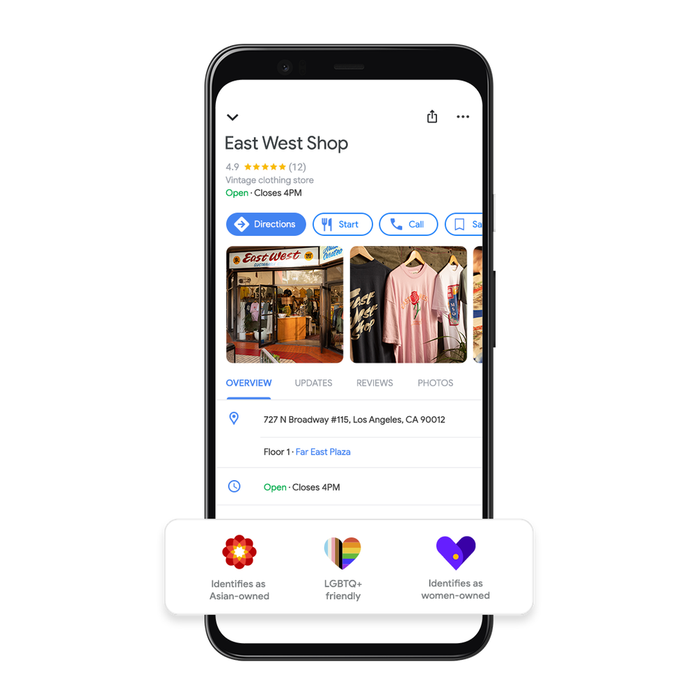
Businesses can opt in to adopt the attribute on their Business Profile and can easily opt out at any time. Once the attribute appears on a Business Profile, users will also be able to see the attribute. This update builds on the Black-owned, Latino-owned, veteran-owned, women-owned andLGBTQ+ owned business attributes, and is another way people can support a diversity of businesses across Google’s products and platforms.

As we were building this feature, we worked with hundreds of Asian-owned businesses to ensure the attribute celebrates our diverse and unique cultures. During that process, I was particularly struck by what Dennys Han, owner of East West Shop, shared with us about the power of community: “If someone is trying to accomplish something, the entire local Korean community will band together to help it come together. The idea of the community and group as a whole uplifting each other is fundamental to what we do.”

Building up Asian-owned businesses’ digital skills

Over the past few years, Grow with Google has partnered with the US Pan Asian American Chamber of Commerce (USPAACC) to help Asian-owned small businesses grow. To date, we’ve helped more than 20,000 Asian-owned businesses expand their digital skills through workshops focusing on topics like e-commerce tools, design thinking for entrepreneurs and making decisions using analytics.

Today, we’re building upon that partnership. Together, USPAACC and Grow with Google will help an additional 10,000 Asian-owned small businesses gain digital skills to help them grow their businesses. And as the internet continues to grow in importance for shopping, nearly one quarter of Asian-owned business owners said their most important channel towards building community and financial support was across social media and online.

It’s our hope the Asian-owned attribute brings people together and provides our communities with much-needed recognition: to help them be seen and thrive. We are excited to spotlight Asian-owned businesses and highlight part of what makes our community unique and important.
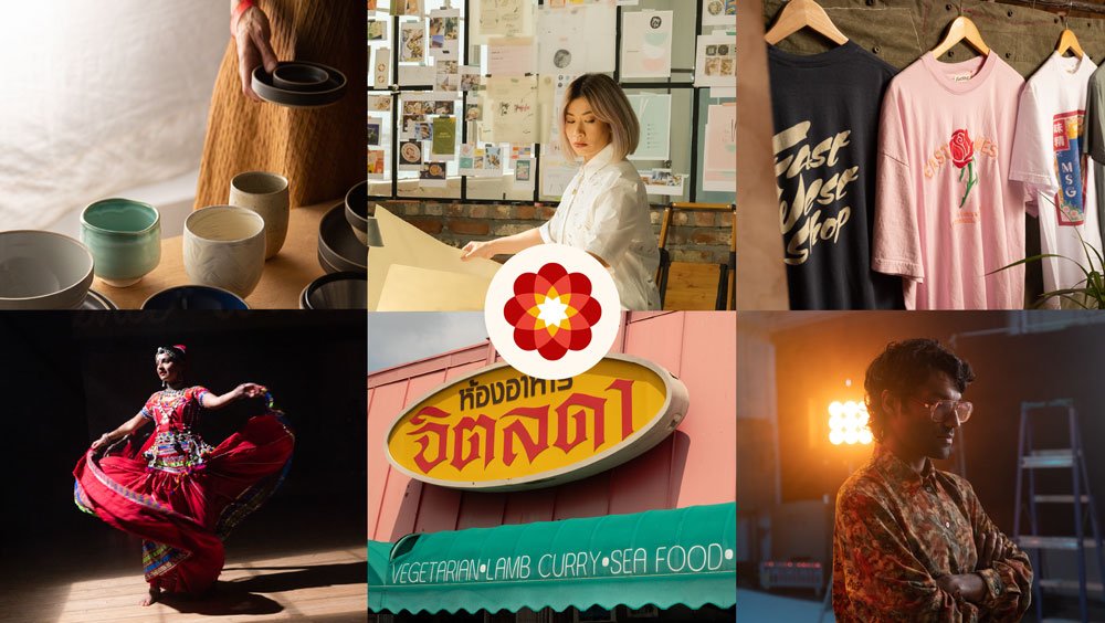
A collage of 6 Asian-owned businesses, 3 on the top and 3 on the bottom with the Asian-owned attribute icon in the middle, a circular design with a red and yellow intertwining flower at its’ core. The top row of 3 (from left to right) include: pottery cups and plates on a table with Tortoise General Store owner holding 2 small dishes in the background, Good Hause Marketing Agency Business owner working, holding a marketing design poster board, and 3 t-shirts (black, pink, and white) hanging in East / West Shop. The bottom row of 3 (from left to right) include: the owner of Bollypop in red traditional dress from India twirling, the storefront of Jitlada restaurant, and the owner of Peru Films facing towards the right, looking down, and crossing his arms.

Top left to right:

Tortoise General Store, Owned by Taku and Keiko Shinomoto

Good Hause, Owned by Brittany Tran

East / West Shop, Owned by Dennys Han

Bottom left to right:

Bollypop, Owned by Aakansha Maheshwari

Jitlada, Owned by Sugar Sungkamee

Peru Films, Owned by Tanmay Chowdhary

Source: Google LatLong


Googlers for climate: meet Lisa Arendt

Based in Zürich, Lisa is Product Partnerships Manager for Maps. She helps partners to integrate their charging station locations into Google Maps, which makes recharging as seamless as possible for e-drivers.

And by seamless, she means that charging should be as easy, safe and reliable as it is with petrol- or diesel-powered cars.

She grew up in a small village near Schwerin, where she still goes to unwind. "There were no buses there. Just one empty street and maybe 20 houses. It's the kind of place where you had to make do with a bicycle," she says.

She doesn't even own a car. "In Zürich, you just don't need one." But today, she owns three bicycles: "A mountain bike for taking a spin in the countryside, a fast racing bike and an old city bike that I won't miss if it gets stolen", she says, laughing.

Lisa is always looking for the best way to get around — not just in her free time, but also at work.

The first big step was to display charging stations on Google Maps, making it easier for drivers to find the nearest charging station. The next step is smart route planning, which Volvo, for example, has already integrated into its vehicles.

We want to make charging electric cars as easy and reliable as possible

Travel has become a recurring theme in Lisa's life. On her journeys around the world, she always enjoyed finding her own routes and choosing the best options. But she says there was always a bigger question on her mind: How can we improve mobility? Not just for individuals, but for everyone.

Four years ago, Lisa took inspiration from the climate strikes organized by Greta Thunberg, and realized it was time to act. "The next generation is clearly telling us what they want from us. And they want it now." This growing movement changed the way people look at electric vehicles.

At the same time, Google Maps created a new global division with a whole range of experts and introduced the first electric vehicle (EV) feature on their maps. In 2020, the first fully integrated solution was created in collaboration with Polestar and Volvo, which developed an electric car with Google Assistant, Maps and Play built into its system.

Several major car manufacturers are now collaborating with Google to offer all-in-one solutions like this.

We’re changing, so the planet can remain the same

More and more drivers are now benefiting from the work that Lisa and her team are doing. According to the latest Global Electrical Vehicle Outlook report, in 2021 nearly 10% of global car sales were electric, which is four times the market share in 2019. This brought the total number of electric cars on the world’s roads to about 16.5 million, triple the amount in 2018. Sales in Europe showed robust growth (up 65% to 2.3 million) after the 2020 boom. And at the same time, more and more car-sharing providers and public transport companies are investing in e-mobility or planning to transition in the near future.

Discussions are already taking place to see how Google and Lisa's team can support them along the way. Lisa's number-one priority for the future is to expand the project globally. She and her team have already come a long way by creating a practical online atlas for electric vehicle charging stations. Yet there are countless other ways to make mobility more sustainable in the future.

Source: Google LatLong


I’m excellent at planning vacations — steal my tips

I once read that the happiest part of traveling is the planning, and I couldn’t agree more. Before I board a plane, I spend hours researching and documenting the what, where and how of my vacation. Over the past two years I’ve traveled far less than usual, but this year my husband and I decided to go to Italy. It was our first time there, and one of our biggest trips since COVID hit, so I took prepping to a new level. Here’s how I, a self-proclaimed travel nerd, used Google tools to get ready for my getaway.

  1. Get everyone on board with Google Slides.

About a month before our trip, I realized we’d done it all wrong. We weren’t going to have enough time to go hiking, and we were adding unnecessary hours of driving — and with increasing gas prices, that would end up costing way too much. Telling your travel partner you want to start over mere weeks before your trip is tough, and I knew I needed to really sell it…so I made a Google Slides presentation.

A screenshot of a Google Slide presentation in edit mode. The main slide on the screen shows a photo of a Google Map route through Italy and text to the left of the map shows a run down of vacation days segmented by how “chill” they are.

One of the many slides I used to convince my husband we needed to replan our trip.

I’ve used Slides for vacation planning in the past, too — and not just to blow everything up and start over. I’ve also presented what I’ve learned about various travel destinations we’re considering to make a decision. This helps me think clearly about what I want out of a vacation; it feels a bit like I’m vision-boarding the potential trip. And apparently it’s a great selling point, because my husband was completely on board by the end of the presentation.

2. Go off the beaten path with Google Maps.

I often find myself aimlessly “wandering” around Google Maps and Street View, looking for unusually shaped peninsulas or clicking into 360-degree photos that seem impossible to have captured. It’s a great way to cure wanderlust from home, but it’s also an effective way to plan travel. This was how I found a few of our stops in Italy.

Animated GIF of a Google Map showing Italy; the cursor zooms in to Lake Garda revealing the small town of Sirmione.

A little Google Maps “wandering” led me to the town of Sirmione. It caught my eye because it’s basically an island in Italy’s Lake Garda: A narrow road connects Sirmione to the mainland; it’s so tiny that most people park on one side and walk over to the rest of the city, going by foot or golf cart.

An aerial photograph of a town surrounded by water.

An aerial shot of Sirmione taken by my husband.

It’s a place I’ve never heard of, and likely never would have gone.

This is also how we found one of our favorites hikes. The Dolomites are massive — choosing where to visit was overwhelming. But my husband noticed an interesting looking area on Google Earth called Seceda (the fact that it was labeled “Seceda famous view” on Google Maps didn’t hurt our interest either). That was enough for us to add it to our itinerary, and I couldn’t be happier that we did — see for yourself.

A photograph of a mountain landscape, with a dramatically slanted mountain in the foreground that reveals a green pasture on one side and a rocky wall on the other.

3. Take organization to another level with Google Sheets.

Using Google Sheets to organize various parts of a trip is admittedly very obvious compared to my first two tips, but here’s how I like to set things up: I have three pages in a Sheet file — one that functions as a list of things to do in each location, one that lists all of our reservation information and a last tab to collect expenses as we accumulate them while planning and during the course of the trip.

A screenshot of a Google Sheets document showing a list of cities in Italy with various attributes across the sheet listing things like dates, food options, bars, etc.

I like to think of everything listed on this first tab as something potentially worth checking out versus something that’s set in stone. This way, we don’t have to waste time while there looking things up — now if we’re ever wondering “what should we do here?” we can turn to the list for quick, easy access to already researched options.

4. Hit the Search bar…and then the Save button.

I’ve always found it easy to find amazing restaurants and shops when I want to travel, but not quite as simple to grasp what the best outdoor areas are — I want to find the best spot for a sunset, or a viewpoint for an afternoon walk. I’ve found more than a few breathtaking sights by heading to Search and simply entering the name of the city I’m visiting. On the right-hand side, there’s a Knowledge Panel about the location with information like the weather, elevation and local time. Below this is a section that says “Plan a trip,” and underneath that a camera icon next to the words “Things to do.”

And that is how I found arguably the cutest landmark in existence, this “Kiss…Please” sign in Sirmione.

A screenshot of the “Things to do” tab on google.com/travel that’s pulled up the “Kiss…please” landmark. The panel shows various photos and a save option in the right hand corner.

I saved the location straight from this panel so it automatically saved to google.com/travel, and we easily found it when we stopped in the city.

Two people standing in front of a sign that reads “kiss…please” and shows two icons kissing. The two people are also kissing. There is a lake and walkway in the background.

We had to!

5. Stay on budget with a bunch of Google tools.

Traveling is expensive, and while this was definitely a trip we planned and saved for, we were very conscious of not exceeding our budget. I used three Google tools to help us do that. First up, Google Flights. Ahead of buying our flights, I created various alerts to airports in Italy to find the best price and timing. (I also used this feature to price hotels.) Then, while we were there, we used Google Maps’ toll feature, so we could avoid more expensive routes. And of course, there’s the aforementioned Google Sheets tab to collect expenses.

All of these things helped me plan (and thoroughly enjoy planning) my trip — and obviously enjoy the trip itself. Whenever you take your next vacation, hopefully these tips are just as useful for you.

Source: Maps


Discover and Support Local Bookstores with Google Maps

Today is National Book Lovers’ Day in the U.S. Since we’ll take any excuse to celebrate our love of the written word, we’ve pulled together top U.S. trends from Search and Maps for our fellow bibliophiles out there, along with tips to hunt down local bookstores that are worth, well, bookmarking. ?

Page-turning book trends 

  • Searching with more than the Dewey Decimal system: So far this year we’ve seen millions of book-related searches on Google Maps — with searches peaking on July 11 when they were up 111% from the same day in 2020. Beach reads anyone?
  • Sweet escape: This year, we’ve been looking to books to transport us to another time, place and world. The top five genres on Google Search for "Best ... books” have included fantasy, sci-fi, mystery, historical fiction and fiction so far in 2021. Meanwhile, others are looking to make this world a little better with “love,” “life,” and “mental health” among the top Google searches for “Books about…” in 2021.
  • Heroes and villains: Who says comics books don’t count? More than 40 states have at least one comic book store among their top ten searched bookstores. Florida leads the pack, with eight comic book stores in its top ten most-searched bookstores on Google Maps.

Give it up for local bookstores 

Now that you have some literary inspiration for your next read, here’s some tips to track down and support independent bookstores near you. And don’t worry, if you’re wondering where you are going to store and display your latest novels — you’re not alone. In January, search interest for “bookcase” hit an all time high. Here’s tips to keep those home libraries growing while showing some local bookstore love.

  1. Discover bookstores near you and save to lists for a future visit. Only halfway through your most recent read, but itching to discover a spot to buy your next one? Use the Explore tab on the Google Maps app to search for bookstores near you. Scroll through the list of local favorites to find information like reviews, hours, location, and even if a bookstore is black-owned or LGBTQ friendly via the attributes on their Business Profile. Once you find a place you love, tap the Save button to add it to an existing list or start a new one for future you.
  2. Follow others on Google Maps for their recommendations.Want to stay in the loop on the newest local bookstores on the block or which book shop has the best used book selection? You can follow bookstore lovers or Local Guides with a literary lean on Google Maps to easily find their recent reviews, recommendations, or photos right in your Updates tab. To follow public profiles simply tap the “follow” button on someone’s profile and get updated when they post reviews or photos. To get you started here’s recommendations from Local Guides on both coasts. If you're in New York City, Local Guides love Book Culture; and for those in Los Angeles some recommend The Book Jewel.
  3. Show love for local bookstores. Leave reviews, add photos, update hours or other missing details about your favorite book stores so other bookworms can discover and learn about the spots you love.

Source: Google LatLong


From widgets to dark mode: 3 updates to Google Maps on iOS

Chocolate or vanilla. ? Crunchy peanut butter or smooth. Androids or iPhones. No matter what your (device) preferences are, Google Maps is here to help you navigate, explore, and get things done as easily as possible. Today, we’re rolling out three new ways to more conveniently access Google Maps’ information about the world right from your iPhone. And while we’re at it, our Googlers are sharing handy tricks you might have forgotten you could do on iOS. ?


Share your live location right from iMessage

If you’re meeting up with friends or family, you can now share your real-time location while you’re texting so you can stay safe and never miss a beat. Just tap on the Google Maps button in iMessage and —  voilà — your location will be shared for one hour by default, with the option to extend up to three days. To end your share, simply tap the “stop” button on the thumbnail.
A GIF of Location Sharing in iMessage

Share your live location right from iMessage

The information you need, fast

One of Google Maps’ most powerful features is the ability to see live traffic conditions in an area. With the new nearby traffic widget, you can now access this information for your current location right from your home screen. So if you're about to leave home, work, school, or any other place, you’ll know at a glance exactly what traffic is like, and can plan accordingly.

Heading to one of your regular spots? With the new Google Maps search widget, you can search for your favorite places or navigate to frequent destinations with just a quick tap. 

An image of the new Google Maps widgets

Access Google Maps’ helpful information right from your iPhone’s home screen.

To install either widget, make sure you have the latest Google Maps app downloaded from the App store and follow these steps:

  1. From your home screen, touch and hold a widget or an empty area until your apps jiggle.

  2. In the upper-left corner, tap the Add button.

  3. Search for and tap the Google Maps app.

  4. Swipe to select a widget, then tap Add Widget.

  5. Tap Done.

A GIF that shows how to install the new Google Maps widgets on iOS

Hold down an app or empty space on your home screen to start installing your new widgets.

Come to the dark side

Experiencing screen fatigue or want to personalize your app? You’re in luck: dark mode on Google Maps for iOS starts rolling out in the coming weeks so you can give your eyes a break or save on battery life. To turn it on, head to your Settings, tap on dark mode, then select “On”.

A screenshot of Google Maps on iOS in dark mode

Rest your eyes and save your battery life with dark mode in Google Maps on iOS.

But that’s not all. To help you get the most out of Google Maps on iOS, check out these tips — using features both new and old — from the people behind Google Maps.

Photo of a male Googler sitting outside

Stay safe 


Google Maps has a ton of features that help me feel more safe when getting around. Whenever I head to a new place, I make sure to use the “Save my parking location” tool so I’m not wandering around looking for my car, especially if it’s dark out. And the offline maps feature is awesome. If I’m going on a hike or I know I’ll have a spotty connection, I download a map of the area to help me avoid getting lost. - Max Kaplan, Social Media 


A photo of a female Googler in front of a restaurant

Make it YOUR map


Whenever I’m on the hunt for a new restaurant, I use the “Your Match” score to figure out how likely I am to like a spot based on my unique tastes (please tell me they have almond milk) so I never waste time and money on a place I probably won’t enjoy. When I’m looking for things to do, I turn to my Community Feed to get an overview of what’s happening in an area, including helpful information from Local Guides, businesses and articles from some of my favorite publishers like The Infatuation. - Madison Gouveia, Communications


Photo of a male Googler wearing a plaid shirt

Use your map to do good


I’m passionate about supporting a diverse set of businesses, and Google Maps makes it easy to do so. With a quick search, I can find nearby businesses that are Women, Black-owned or LGBT-friendly, and quickly learn more about their products, services, and mission with just a few taps. Then, I use Live View, our AR-powered walking directions, to quickly navigate there.  - Bilawal Sidhu, Product 


Make sure to check out all of today’s newest features, which will be available for everyone using Google Maps on iOS this month.

Source: Google LatLong


Navigate new normals with Google Maps

With the state of the pandemic varying across the globe, the new normal looks different depending on where you go. But no matter your situation, Google Maps has your back with new tools to help you navigate and explore as safely as possible.

Keep your distance on mass transit

It’s no surprise that transit ridership took a drastic plunge during the early days of the pandemic. While people are returning to public transit — with transit directions on Maps increasing 50% compared to last year in the U.S. — safety remains top of mind. That’s why we’re expanding transit crowdedness predictions to over 10,000 transit agencies in 100 countries so you’ll know if your line is likely to have lots of open seats, hit full capacity, or be anywhere in between. With this information you can decide whether you want to hop on board or wait for another train. Because pandemic or not, no one likes standing in a jam-packed subway car. 


These predictions are made possible through our AI technology, contributions from people using Google Maps, and historical location trends that predict future crowdedness levels for transit lines all over the world. All these predictions were designed with privacy in mind. We apply world-class anonymization technology and differential privacy techniques to Location History data to make sure your data remains secure and private.


A GIF of transit crowdedness predictions being used on Google Maps in a Pixel phone

Transit crowdedness predictions are expanding to over 10,000 cities in 100 countries

In New York and Sydney, we’re piloting the ability to see live crowdedness information right down to the transit car level. This feature is powered by data from agencies like Long Island Rail Road and Transport for New South Wales, with more cities coming soon.


So how is transit crowdedness trending across the U.S.? New York City, Atlanta, San Francisco, Boston, and Washington D.C. lead the pack as some of the cities with the most crowded lines. Nationally, you’re most likely to get a seat at 9 a.m, whereas cars may be standing room only between 7-8 a.m. In the evening, leaving earlier than rush hour will up your chances of grabbing a seat, with lines being far less crowded at 3 p.m. than they are between 4-5 p.m.


A screenshot of a Pixel phone that shows transit directions and crowdedness predictions on Google Maps

See live crowdedness at the transit car level in Sydney and New York

Be intentional with your time

After living through a global pandemic, people have told us that they want to be more intentional about how they spend their time. The new Timeline Insights tab, which is visible only to you, can help you do just that. If you're an Android user and you’ve chosen to turn on Location History, you’ll see a new tab in your Timeline (just tap on your profile photo, then Your Timeline to find it) that provides monthly trends about how you’re navigating the world. You’ll see which modes of transportation you’ve used and the distance and time you’ve driven, flown, biked or walked. You can also see how much time you’re spending at different places — like shops, airports and restaurants — and instantly drill down to see all the places you visited.

A GIF of Google Maps’ new Timeline Insights feature on a Pixel phone

See helpful insights and trends about places you visit

Reminisce about past trips and plan future ones when you feel safe

If you’re feeling nostalgic but not quite ready to travel yet, head on over to the Trips in Timeline tab which is now live for everyone on Android. Use Trips in Timeline to relive parts of past vacations, like which hotels you stayed at during that epic trip to Tokyo or the restaurants you visited on your weekend getaway. Planning ahead? Export these places to a list and share them with friends who need travel recommendations.

A GIF of Google Maps’ Trips in Timeline feature on a Pixel phone

Use Trips in Timeline to reminisce about past trips and plan new ones

If you want to edit your information, you can easily manage your data — in bulk, in-line, or with auto-delete controls — right from your private Timeline.

Leave more detailed reviews

We’re making it even easier to keep your community up to date and support local businesses with reviews. Now when you leave a review for a restaurant, you’ll see prompts to share useful information, such as price ranges or if you got takeout or delivery. Best of all: You can answer with just a few quick taps. This is now live for all restaurants in the U.S. on Android and is rolling out to iOS, with more categories and countries on the way.

A GIF showing new prompts you can answer on Google Maps to share even more helpful information about a business.

Share helpful information about a restaurant with a few easy taps

Navigating this ever-changing ‘normal’ will take some getting used to, but Google Maps is here to help you get your bearings. Check out a few more helpful tips to help you plan and get around — whether you’re using Google Maps on Android or iOS.

Source: Google LatLong


8 tips to navigate and explore safely with Google Maps

With the state of the pandemic varying around the world, keeping up with local restrictions, navigating day-to-day life and easing back into activities we enjoy can feel confusing and unfamiliar. 

To help with that, we’ve pulled together Google Maps tips — including new features and product updates — to help you safely plan your next outing, navigate how and when to get things done, and relive past adventures or plan for future ones when the time is right:

  1. Plan ahead if you’re taking public transit: Before heading out, check to see how crowded your bus, train, or subway car is likely to be — so you’ll know if you’re likely to grab a seat or if you should wait for another train. You’ll be able to see transit crowdedness predictions for over 10,000 transit agencies in 100 countries around the world.
  2. Find the latest information about COVID-19:Whether you’re staying close to home or taking a trip, use the COVID layer to see how cases are trending in an area. You can also access quick links to trusted local resources so you’ll know at a glance if there are specific guidelines or restrictions you need to follow.
  3. Avoid crowds with live busyness information: Before you go, search for your destination on Google Maps, then scroll down on the Business Profile to see how busy a place typically is or how busy it is right now. With busyness information, you’ll know instantly you’re about to face a long line or a big crowd and can adjust your plans accordingly. 
  4. Reserve your spot:Many places are now appointment only. You can reserve your spot ahead of time right from Google Maps with participating businesses. Simply search for the business, check upcoming availability, and book! If you need to change something, manage upcoming reservations and bookings within the Saved tab of the Google Maps app.
  5. Tap and go with contactless payments: Pay for things likestreet parking or public transit right from Google Maps without having to pull out your wallet or touch a parking meter. For street parking, type in your meter number, hit pay and refill while you’re out and about. For public transportation, a payment option will pop up once you arrive at any public transit, then tap your phone to pay. 
  6. Know before you go:Check out local places’ Business Profiles on Google Maps to see information like operating hours, current COVID-19 safety precautions, trending dishes and reviews. 
  7. Leave a review: Support local businesses you love and leave a review on Google! Now you can tap on prompts to quickly share helpful information for any restaurant in the U.S. — like the average price range or whether you dined in or ordered takeout. 
  8. Reminisce on past trips: Figure out where you want to go next by taking a look at where you’ve been with the Trips tab. Available to all Android users, you can now use the Trips tab to transport yourself back in time to that one dinner in Italy (you know the one) or that epic camping weekend in Big Sur. Become everyone’s go-to travel guide and export these places to a list to share.

Source: Google LatLong


The complete Google guide to summer 2021

The sun is shining, the days are getting longer and more and more U.S. cities are reopening — it’s official, summer 2021 is almost here. Right on time, vacation fever has hit: Google searches for “summer vacation” and “sunscreen” are seeing a major spike, and those are just a couple of the many interesting Google Trends we’ve been seeing. So we decided to collect some of this information to bring you Google’s Guide to Summer: You’ll find trending travel spots, must-eat-at restaurants and tips for finding the perfect summer gear. 

To find what places are turning into vacation destinations, we looked at places with the highest percentage growth in hotel searches, comparing April 2021 to April 2019. These 10 cities saw the biggest bump in interest: 

Infographic showing the top 10 trending vacation destinations.

If you’re planning a trip to one of these places, the next step is deciding where to eat while you’re there. Hidden Gem restaurants are verified restaurants on Google Maps with high ratings from fewer people — which could help you avoid crowds and get an amazing meal. Check out these Hidden Gems from each of the cities listed above: 

Infographic listing the top three hidden gem restaurants in each top tending vacation destination.

If you’re not ready to travel by plane, you’re not alone. Many people are looking into alternative transportation options or even local options, such as… 

  • ?Glamour-BUS travels:In the U.S., there are over 60% more RV-related searches on Google Maps than there were a year ago. The metro areas most interested were Los Angeles, Phoenix, Houston, Dallas and Denver. 

  • ?️ Beachy keen:As the weather heats up, U.S. Maps searches for “beaches” are up over 40% compared to May 2020, and searches for "parks" are up over 50%. 

  • ?Happy campers: Camping-related searches on Maps are trending up nearly 90% compared to this time last year. The top five areas interested in camping are Los Angeles, the San Francisco Bay Area, New York, Denver and Seattle.

  • ? Tourists on tires: People are using Google Maps for cycling directions 44% more than they were in 2020. According to our cycling direction data, New York, Los Angeles, Chicago, San Francisco and Washington D.C. are the cities with the most cyclists. 

Infographic showing the top airline alternative forms of travel.

Whether you hit the road (or skies) or stay put, you’ll want to grab the right gear. Try these Google Shopping power tips to find whatever you need for summer:

  • Check if you’re getting a “good” price on that retro cooler: On a Shopping product page, you’ll see a price bar showing whether the price you’re seeing for that product is high, low or typical, compared to current prices from across the web and in nearby stores.

  • See if an inflatable pool (or whatever else) is in stock at local stores:With Google Shopping, you can search for a product, like inflatable pools, and apply the “Nearby” filter (or include “near me” in your search) to show results from local retailers on a helpful map display, along with an indication of whether the product is in-stock. 

Image showing a popsicle floatie floating in a pool.
  • Compare prices and shipping options for a summer koozie:Once you’ve found your favorite koozie, scroll down on the product page and tap “Compare prices” to see all of the prices and shipping options from online and local retailers for that product. You’ll also see whether a retailer offers curbside pickup and/or the option to buy online/pickup in store.

  • Use filters to find the perfect sunscreen (or other beauty products):On Google Shopping you can easily use filters to find the type of product you’re looking for. When you search “sunscreen” you can simply scroll down and on the left hand side you’ll find rating filters under “Product Rating” such as four stars and above.

  • Get summer picnic or beach ideas and see product availability on Google:Google Images is a great place to find summer inspo. You can see availability information so you know if the item you're looking for is actually in stock. You can even use Lens to find that retro beach towel or picnic blanket your friend or your favorite celeb has. Once you find it, Google will give you options for how to buy it.

Consider yourself set for the summer!

Source: Google LatLong