Category Archives: Google LatLong Blog

News and notes by the Google Earth and Maps team

Hailing more ride service options in Google Maps

Back in March, we introduced a new way for people to find and compare the fastest ways to get around town by adding a new ride services tab when searching for directions in Google Maps. Today, we’re adding two more partners in the U.S., Lyft and Gett. Now Google Maps will display options from 9 ride-sharing partners in over 60 countries, allowing you to compare the fastest, most affordable ride near you, without having to download and open multiple apps.

Say you’re looking to get from the High Line to Times Square in Manhattan. When typing these locations into the Google Maps app, you’ll see a ride services tab appear alongside driving, transit and walking directions. Just tap the icon and you’ll find fare estimates and pick up times from multiple ride service partners, depending on driver availability. We’ll also show various types of services offered by each partner— for instance Lyft may also show options for a Lyft Line ride.

Uber_Lyft.png

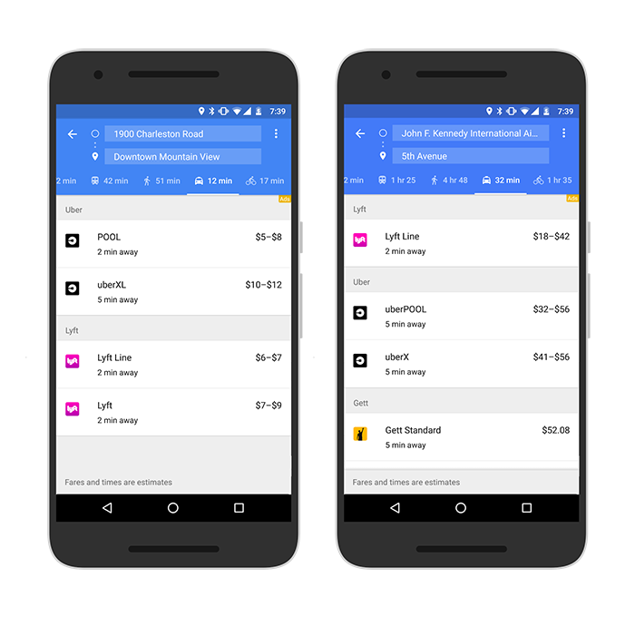
Ride options from Lyft will begin appearing across the U.S., while Gett will show availability within New York City. So the next time you find yourself with an appointment across the city, just open the Google Maps app on iOS or Android and take it for a spin.

Source: Google LatLong


Sheep View: Where there’s a wool, there’s a way

Over the past three months, Durita Andreassen and a few friendly sheep equipped with solar-powered cameras strapped to their woolly backs set out to collect imagery of the Faroe Islands for Street View. The 18 Faroe Islands are home to just 50,000 people, but — fittingly for a country whose name means “Sheep Island” — there are 70,000 sheep roaming the green hills and volcanic cliffs of the archipelago. So when Durita decided to document the country for Street View, sheep weren’t a baaad place to start.


When we herd about the Sheep View project, we thought it was shear brilliance. So we decided to help the Faroese by supplying them with a Street View trekker and 360 cameras via our Street View camera loan program. Last week, the Google Maps team arrived in the Faroe Islands to help train and equip the local community to capture even more (but slightly less woolly) Street View imagery.


Now that the Faroe Islands is supplied with a Trekker and 360 cameras, residents and tourists can assist the sheep in collecting Street View imagery of their beautiful lands using selfie-sticks, bikes, backpacks, cars, kayaks, horses, ships and even wheelbarrows. The Visit Faroe Islands office in Tórshavn and Atlantic Airways at the airport will be lending out Street View 360 cameras to visitors willing to lend a hoof.

The Faroe Islands have shown us that even sheep can contribute to Street View. If your hometown or favorite hiking trail hasn’t made it into Google Maps yet, grab your own 360 camera or apply to borrow one from us through our Street View camera loan program. We’re excited to see what ewe map!


Published By: David Castro González de Vega - Google Maps Program Manager


Source: Google LatLong


Sheep View: Where there’s a wool, there’s a way

Over the past three months, Durita Andreassen and a few friendly sheep equipped with solar-powered cameras strapped to their woolly backs set out to collect imagery of the Faroe Islands for Street View. The 18 Faroe Islands are home to just 50,000 people, but — fittingly for a country whose name means “Sheep Island” — there are 70,000 sheep roaming the green hills and volcanic cliffs of the archipelago. So when Durita decided to document the country for Street View, sheep weren’t a baaad place to start.

When we herd about the Sheep View project, we thought it was shear brilliance. So we decided to help the Faroese by supplying them with a Street View trekker and 360 cameras via our Street View camera loan program. Last week, the Google Maps team arrived in the Faroe Islands to help train and equip the local community to capture even more (but slightly less woolly) Street View imagery.

Now that the Faroe Islands is supplied with a Trekker and 360 cameras, residents and tourists can assist the sheep in collecting Street View imagery of their beautiful lands using selfie-sticks, bikes, backpacks, cars, kayaks, horses, ships and even wheelbarrows. The Visit Faroe Islands office in Tórshavn and Atlantic Airways at the airport will be lending out Street View 360 cameras to visitors willing to lend a hoof.

SheepView_3.png

The Faroe Islands have shown us that even sheep can contribute to Street View. If your hometown or favorite hiking trail hasn’t made it into Google Maps yet, grab your own 360 camera or apply to borrow one from us through our Street View camera loan program. We’re excited to see what ewe map!

Look Google is coming

Source: Google LatLong


Explore the hidden worlds of the National Parks

In the Kenai Fjords, the ice is so dense it forms blues brighter than the clear Alaskan sky above. The molten rock around the (very) active Kīlauea Volcano appears to swirl and move — and sometimes it really does! At Bryce Canyon, one of the darkest places in North America, you can see the massive Milky Way glittering across the night sky.

The U.S. National Parks are full of wonders, but most people don’t get the chance to visit in person. While nothing beats the real thing, for this month’s 100th anniversary of the National Parks Service, we wanted to see if we could use Google’s technology to help share the parks with everyone.


Starting today anyone can take a virtual tour of some of our most breathtaking National Parks, no matter where you are, with Google’s The Hidden Worlds of the National Parks.

Explore the Hidden Worlds of the National Parks

This Google Arts & Culture exhibit and interactive documentary in honor of this month’s NPS Centennial is available on the web and in the Google Arts & Culture App oniOS/Android. You can immerse yourself in 360-degree video tours through some of the most remote and breathtaking places in five different National Parks. And if you want to learn more about what you’re seeing, you can browse the fascinating archive of artifacts from the National Parks’ many museums.

At each park, a local ranger guides you through places most people never get to go — spelunking through ancient caves at Carlsbad Caverns, flying above active volcanoes in Hawai’i, and swimming through the coral reefs of the Dry Tortugas in Florida.

Behind the scenes of The Hidden Worlds of the National Parks

We’ve also created the Hidden Worlds Expedition for educators to help open up new learning opportunities and share these experiences with even more people. The Expedition can be accessed on the Expeditions App (available on Google Play in the U.S.).

Google Doodle Celebrating U.S. National Parks

Today's Doodle celebrating U.S. National Parks & monuments. More info at google.com/doodles.

The National Parks are American treasures, and everyone should see what they have to offer. We hope that by making it easy for people to get a taste of the wilderness, we can encourage a new generation of parks goers to head out and explore in person. Get ready for an adventure!

Source: Google LatLong


Five Trending Roadside Attractions for Your End of Summer Road Trip

Summer just isn’t complete without a road trip. Whether you cruise Route 66 from coast to coast or take a short drive out of the city, there are plenty of quirky attractions along the way. We looked at Google Maps data from the past few years to uncover which weird and wonderful roadside attractions are searched for more during the summer months than during the rest of the year. Here’s a curated list of some trending roadside gems across the country.


Roadtrippers leaving California for the beautiful Oregon landscape shouldn’t miss the Trees of Mystery attraction just 36 miles south of the Oregon border. Despite the name, the true showstoppers are the 49-foot-tall statue of Paul Bunyan and the 35-foot-tall Babe the Blue Ox – both of which are visible from Highway 101.


Downtown Seattle sports a notoriously sticky tourist attraction: a wall covered in gum. Although the wall was scrubbed clean back in 2015, it returned to all its glory in no time. Road trippers who find themselves at the famous Pike Place Market need only wander downstairs to Post Alley to behold the man-made (or chewed) marvel.


Just off Route 66, weary travelers can take a break to picnic, swim, or fish at the small lake that’s home to a big Blue Whale. To cool off from their long drives visitors fling themselves off his tail, slide down his fins and pose for photos in his open jaws.


Fewer than 30 minutes from Atlantic City, travelers can take in another larger than life creation – Lucy the Elephant. Lucy is a 132-year-old elephant-shaped building that towers six-stories tall. Visitors can enter the structure and climb up to the howdah (the carriage positioned on the back of an elephant) for a picturesque view of the beach below.


Take a short detour off I-95 in Connecticut to take a trip back in time to the Jurassic period. Northeastern roadtrippers will find 40 life-sized dinosaur figures on a 1.5-mile nature trail in The Dinosaur Place. And the best part is that they don’t have to worry about any real-life velociraptors.

Next time you’re on a road trip, remember to take a break and explore the roadside attractions along your route. Google Maps can help you do just that with a variety of features like offline maps, the ability to search for places along your route, and the option to create multi-stop trips (now available on Android and iOS). After all, the journey can be just as much fun as the destination.

Posted by Pierre Petronin, Quantitative Analyst, Google Maps

Source: Google LatLong


Five trending roadside attractions for your end of summer road trip

Summer just isn’t complete without a road trip. Whether you cruise Route 66 from coast to coast or take a short drive out of the city, there are plenty of quirky attractions along the way. We looked at Google Maps data from the past few years to uncover which weird and wonderful roadside attractions are searched for more during the summer months than during the rest of the year. Here’s a curated list of some trending roadside gems across the country.

Roadtrippers leaving California for the beautiful Oregon landscape shouldn’t miss the Trees of Mystery attraction just 36 miles south of the Oregon border. Despite the name, the true showstoppers are the 49-foot-tall statue of Paul Bunyan and the 35-foot-tall Babe the Blue Ox – both of which are visible from Highway 101.

Downtown Seattle sports a notoriously sticky tourist attraction: a wall covered in gum. Although the wall was scrubbed clean back in 2015, it returned to all its glory in no time. Road trippers who find themselves at the famous Pike Place Market need only wander downstairs to Post Alley to behold the man-made (or chewed) marvel.

Just off Route 66, weary travelers can take a break to picnic, swim, or fish at the small lake that’s home to a big Blue Whale. To cool off from their long drives visitors fling themselves off his tail, slide down his fins and pose for photos in his open jaws.

Fewer than 30 minutes from Atlantic City, travelers can take in another larger than life creation – Lucy the Elephant. Lucy is a 132-year-old elephant-shaped building that towers six-stories tall. Visitors can enter the structure and climb up to the howdah (the carriage positioned on the back of an elephant) for a picturesque view of the beach below.

Take a short detour off I-95 in Connecticut to take a trip back in time to the Jurassic period. Northeastern roadtrippers will find 40 life-sized dinosaur figures on a 1.5-mile nature trail in The Dinosaur Place. And the best part is that they don’t have to worry about any real-life velociraptors.


Next time you’re on a road trip, remember to take a break and explore the roadside attractions along your route. Google Maps can help you do just that with a variety of features like offline maps, the ability to search for places along your route, and the option to create multi-stop trips (now available on Android and iOS). After all, the journey can be just as much fun as the destination.

Source: Google LatLong