The world’s oceans and fisheries are at a turning point. Over a billion people depend on wild-caught fish for their primary source of protein. Fisheries are intertwined with global food security, slave labor issues, livelihoods, sovereign wealth and biodiversity but our fisheries are being harvested beyond sustainable levels. Fish populations have already plummeted by 90 percent for some species within the last generation, and the human population is only growing larger. One in five fish entering global markets is harvested illegally, or is unreported or unregulated. But amidst all these sobering trends, we're also better equipped to face these challenges — thanks to the rise of technology, increased availability of information, and a growing international desire to create a sustainable future.
Today, in partnership with
Oceana and
SkyTruth, we’re launching
Global Fishing Watch, a beta technology platform intended to increase awareness of fisheries and influence sustainable policy through transparency. Global Fishing Watch combines cloud computing technology with satellite data to provide the world’s first global view of commercial fishing activities. It gives anyone around the world — citizens, governments, industry, and researchers — a free, simple, online platform to visualize, track, and share information about fishing activity worldwide.
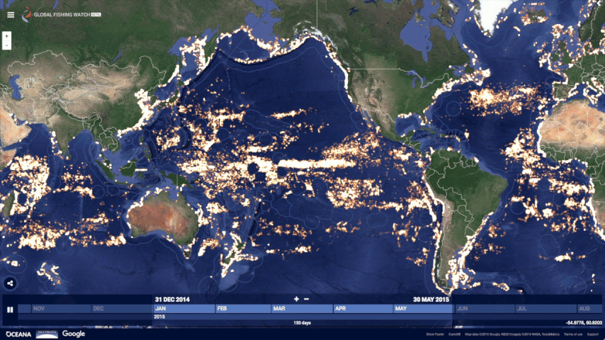
Global Fishing Watch, the first global view of large scale commercial fishing activity over time
At any given time, there are about 200,000 vessels publicly broadcasting their location at sea through the Automatic Identification System (AIS). Their signals are picked up by dozens of satellites and thousands of terrestrial receivers. Global Fishing Watch runs this information — more than 22 million points of information per day — through machine learning classifiers to determine the type of ship (e.g., cargo, tug, sail, fishing), what kind of fishing gear (longline, purse seine, trawl) they’re using and where they’re fishing based on their movement patterns. To do this, our research partners and fishery experts have manually classified thousands of vessel tracks as training data to “teach” our algorithms what fishing looks like. We then apply that learning to the entire dataset — 37 billion points over the last 4.5 years — enabling anyone to see the individual tracks and fishing activity of every vessel along with its name and flag state.
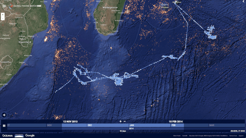
An individual vessel fishing off Madagascar
This data can help inform sustainable policy and identify suspicious behaviors for further investigation. By understanding what areas of the ocean are being heavily fished, agencies and governments can make important decisions about how much fishing should be allowed in any given area. Often, fish populations are so depleted that the only way to ensure they are replenished is to create “no take areas” where fishing is not allowed. Our hope is that this new technology can help governments and other organizations make decisions about which areas need protection and monitor if policies are respected.
Kiribati's Phoenix Island Protected Area transitioning from heavy tuna fishing to a protected area.
Partners have already started using Global Fishing Watch and have committed to providing additional data sources for greater impact:
- Indonesia’s Minister of Fisheries and Marine Affairs, Susi Pudjiastuti, has committed to making the government’s Vessel Monitoring System (VMS) public in Global Fishing Watch in 2017. Ibu Susi has been a progressive leader for transparency in fisheries with other governments now expressing similar interest to collaborate.
- Food and Agriculture Organization of the United Nations will collaborate on new research methodologies for reporting spatial fishery and vessel statistics, building on Global Fishing Watch and developing transparency tools to support their member states in improving the monitoring, control and surveillance of fishing activities.
- Trace Register, a seafood digital supply chain company, has committed to using Global Fishing Watch to verify catch documentation for its customers such as Whole Foods.
- Bali Seafood, the largest exporter of snapper from Indonesia, has teamed up with Pelagic Data Systems, manufacturers of cellular and solar powered tracking devices to bring the same transparency for small scale and artisanal fishing vessels, into Global Fishing Watch as part of a pilot program.
We’ve also developed a Global Fishing Watch Research Program with
10 leading institutions from around the world. By combining Google tools, methodologies, and datasets in a collaborative environment, they’re modeling
economic, environmental, policy, and climate change implications on fisheries at a scale not otherwise possible.
Global Fishing Watch was not possible five years ago. From a technology perspective, satellites were just beginning to collect vessel positions over the open ocean, and the "global coverage" was spotty. There has been tremendous growth in machine learning with applications in new fields. Policy and regulatory frameworks have evolved, with the United States, European Union, and other nations and Regional Fishery Management Organizations now requiring that vessels broadcast their positions. Market forces and import laws are beginning to demand transparency and traceability, both as a positive differentiator and for risk management. All of these forces interact and shape each other.
Today, Global Fishing Watch is an early preview of what is possible. We’re committed to continuing to build tools, partnerships, and access to information to help restore our abundant ocean for generations to come.
Go explore your ocean at
www.globalfishingwatch.orgPosted By: Brian Sullivan, Google Lead -
Global Fishing Watch, Sr. Program Manager -
Google Ocean & Earth Outreach