Category Archives: Google LatLong Blog

News and notes by the Google Earth and Maps team

Time to discover new places in Africa. Ghana, Senegal and Uganda now on Street View

From the lovely scenic mountains of the south, to the beautiful beaches of the west, and the exotic parks of east, the regions of Africa contain some of the most breathtaking views in the world.

Starting today, you can take virtual tours of some of the most iconic landmarks and monuments in Ghana, Senegal and Uganda. That means Street View now covers 81 countries from across the world, and seven in Africa.

You can now virtually explore the UNESCO World Heritage-classified village of Nzulezo in Ghana, which is built over Lake Tadane, and consists of stilt-supported structures integrated seamlessly with the water-dominated natural landscape.

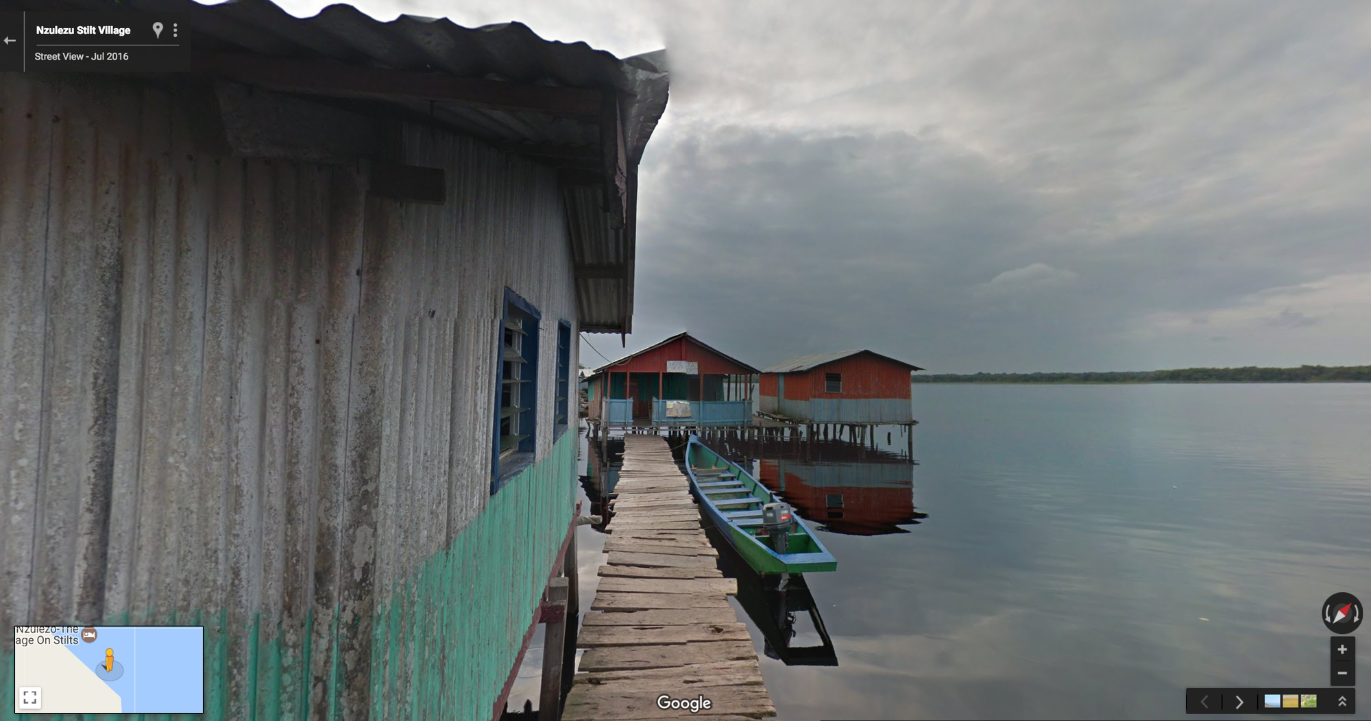
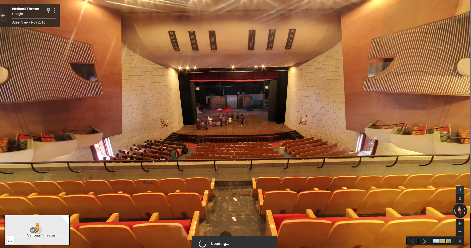
If you have an eye for cultural entertainment, you can now also take a virtual walk inside the National Theatre of Ghana, home to the three resident companies of the National Dance Company, the National Symphony Orchestra, and the National Theatre Players.

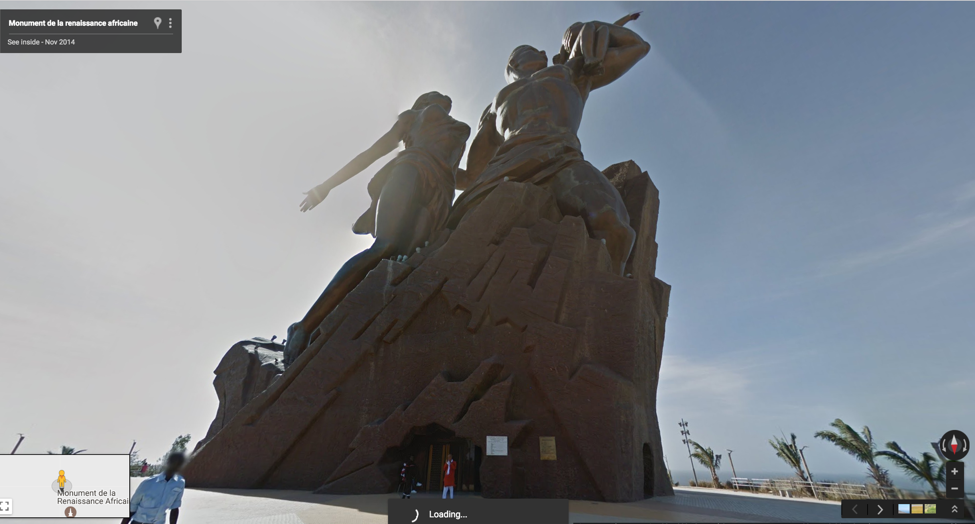
Explore amazing African art by taking a tour of Senegal’s imposing African Renaissance monument, a 49 meter tall bronze statue on top of one of the twin hills just outside Dakar, Senegal.

Other iconic landmarks now in Street View include the stunning Lake Retba, a unique lake known for its pink waters, and take a “drive” through major roads and towns including Dakar, Saint Louis, Thies and Touba.

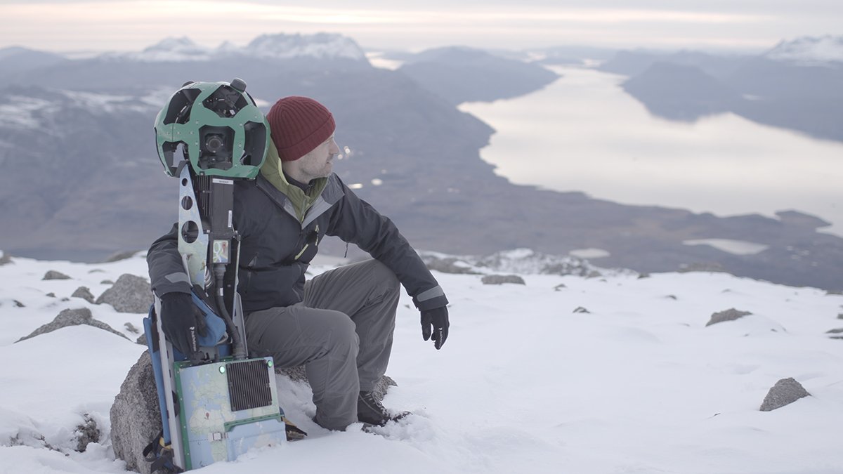
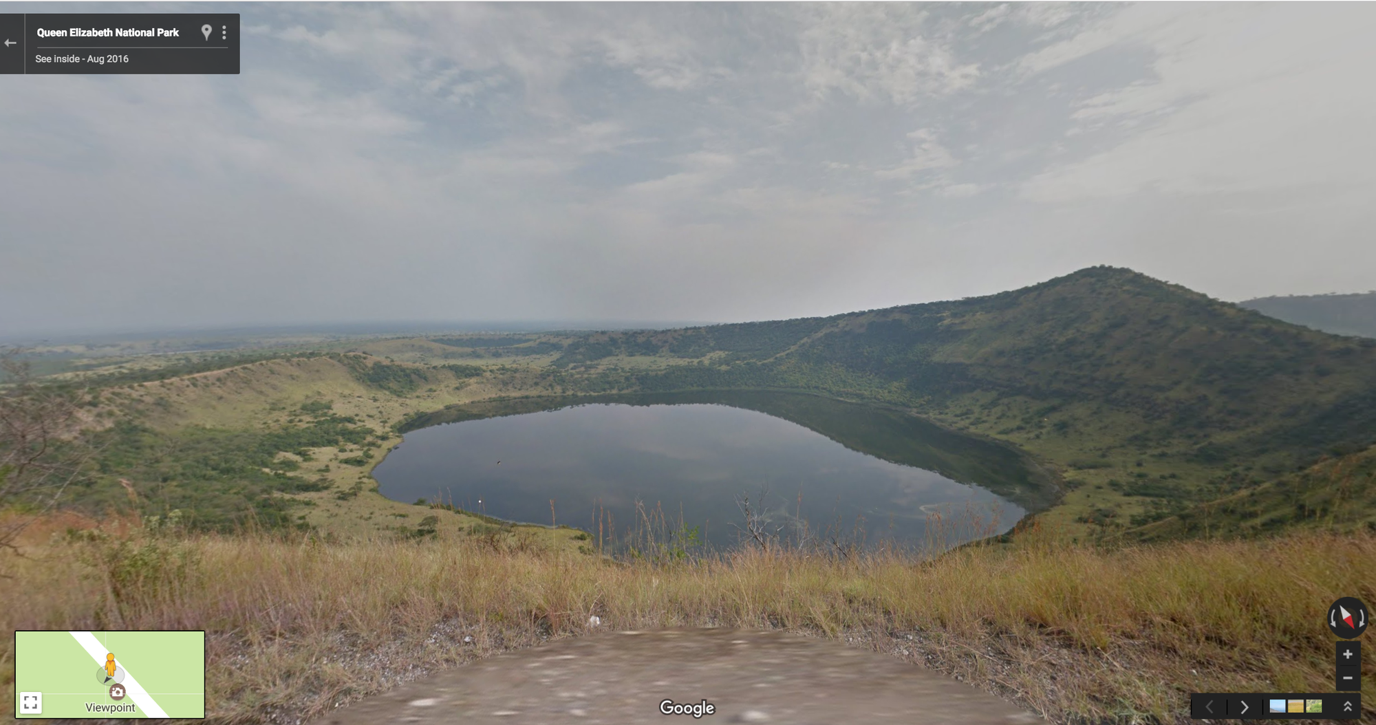
We partnered with the Uganda Wildlife Authority to capture imagery of some of Uganda's most beautiful and iconic National Parks, home to an amazing variety of wildlife. With our Street View Trekker, either carried by our team or mounted on a vehicle, we travelled through seven parks, including the stunning Queen Elizabeth National Park, which is home to 10 primate species, including chimpanzees, and more than 600 species of birds.

We're excited that what began with a few South African cities in 2009, has now expanded to many other cities in seven countries across the continent. From Cape Town to Botswana, Kenya, Tanzania and now Ghana, Uganda and Senegal, we're glad that more people from around the world can get a glimpse of this beautiful continent. We think you'll be tempted to pack your own cameras to explore in person as well!

Source: Google LatLong


Nikolaj Coster-Waldau documents the changing landscape of Greenland

Editor’s note: Today’s post comes from Nikolaj Coster-Waldau, “Game of Thrones” star and newly-appointed U.N. Goodwill Ambassador. Nikolaj partnered with our Street View team to collect imagery of Greenland's beautiful and changing landscape, where the impact of global warming can be seen firsthand.

Year after year we’ve seen record high temperatures across our planet due to global warming. And Greenland, which I consider my family's second home, is changing faster than anywhere else on Earth. Here the effects of climate change are easy to see: as sea ice melts and glaciers crumble, places once covered in ice are now bare land.

Greenland Glacier

See Greenland Glacier in Timelapse

Late last year, the Google Maps team came to visit and we went on an adventure to collect Street View imagery of Greenland. Statistics, scientific reports and graphs can be bewildering, but I hope seeing these images will help people understand the drastic changes taking place in Greenland, and inspire you to fall in love with it the way I have. Unless we change these climate trends, the next time we bring the trekker to Greenland the landscape may be unrecognizable from what you see today.

Nikolaj Trekker

Our first stop is the town of Igaliku. With a population of just 27, Igaliku is one of Greenland’s most idyllic villages—a smattering of brightly colored houses and hillsides dotted with sheep. As the landscape has changed, so too has the local economy. Alongside new opportunities to mine precious metals that were previously inaccessible, the changing patterns of freezing and melting glaciers have dramatically disrupted the fishing and hunting lifestyles that have sustained the local Inuit population for centuries.

Igaliku

Greenland is also known for its hot springs. The geothermal springs on the remote island of Uunartoq are one of my favorite destinations, with views of icebergs and towering snow-capped mountain peaks.

Hotspring

Our final stop is the majestic glacial-covered Qoorog Fjord, where the second largest ice sheet in the world terminates into the sea. The ice sheet is melting at an increased pace—pouring 300 billion tons of ice into the ocean each year. This melting harms important coastal ecosystems, local food and water supplies and is a major contribution to rising sea levels.

Ice

We have a responsibility to protect this beautiful planet we live on, and I’m starting at my own front door. But everywhere and everyone is vulnerable to the effects of our warming planet. Let’s band together and do something about it—learn about global efforts to combat climate change and discover ways to take action.

Source: Google LatLong


Get real-time commute info and more in one tap

Starting today we’re rolling out an update to Google Maps on Android that provides helpful everyday info—in real time—at the bottom of your home screen. Just swipe up and you’ll see three tabs that will help you find a nearby restaurant, beat traffic, or catch the next bus.

Maps_US HomescreenComp-1.gif

Under the places tab, you’ll see curated lists of places to eat and drink like “best dinners,” “cheap eats” or “business dining,” around you or in any location you choose. In one tap you can also search for other everyday spots like ATMs, pharmacies, gas stations and grocery stores. Peek at images of the area or read a short description of the neighborhood to get the lay of the land.

homescreen_US_pixel_places.png

Under the driving tab, if you have your home and work addresses saved, you’ll see real-time ETAs to home and work, as well as a nearby traffic conditions report and expected delays on the road ahead. If you don’t need turn-by-turn directions but want real-time traffic info as you take your usual route, you can tap on “start driving” to go directly into driving mode.

homescreen_US_pixel_driving.png

With  the transit tab, you’ll never have to sprint to the bus again. If you have your home and work addresses saved, you’ll see a recommendation for which bus or train to take, when the next one’s coming, and an ETA for when you’ll arrive at work or home. If you’re headed somewhere else, you can swipe down to find nearby transit stations along with real-time schedules.

homescreen_US_pixel_transit.png

When you're on the go, there's no time for apps that can't keep up.Whether you need to get to work or you’re just looking for a quick bite around you, Google Maps gives you the personalized information about your world to make decisions and get around with confidence.

Source: Google LatLong


Know before you go: parking difficulty on Google Maps

It’s Friday night and you hit the road early enough to make it to a movie, grab some buttery popcorn, and catch the previews. But when you get to the theater, parking is hard to come by and you spend the next 20 minutes circling the lot and side streets until a spot finally opens up. You get to your seat just in time for the opening credits…and no popcorn!  


Factoring in time for parking can make or break a night out, let alone making it to that big meeting on time. So in 25 metro areas throughout the U.S., we’ve introduced a new parking difficulty icon in Google Maps for Android that’ll give you a heads up on what kind of parking crunch to prepare for when you’re on the go.

Parking-Limited

To see how hard it might be to park where you’re headed, just get directions to your destination and look for the parking difficulty icon in the directions card at the bottom of the screen. Parking difficulties range from limited to medium to easy and are based on historical parking data (similar to how we calculate Popular Times and Visit Duration).


For now, look out for parking difficulty icons in the following metro areas across the U.S.: San Francisco, Seattle, Miami, Atlanta, Boston, Charlotte, Chicago, Detroit, Los Angeles, Minneapolis/St. Paul, New York City, Orlando, Philadelphia, Pittsburgh, San Diego, St. Louis, Tampa, Washington, DC, Cleveland, Dallas/Fort Worth, Denver, Houston, Phoenix, Portland and Sacramento.

Source: Google LatLong


A virtual trek through Petra with Google Cardboard

Last year, we launched a virtual tour of Petra and more than 30 historical sites across Jordan in Google Street View. The interactive Maps experience took visitors on an intimate journey into Jordan’s lost city of stone—and now, we’ve made this historic trek even more immersive with a 360º experience for Google Cardboard.  

Petra_Blog_Cardboard_Creative_V2_grey.png

We’ve used 360º mapping, aerial imagery and millions of photos stitched together, to recreate six of Petra’s most beautiful and iconic panoramas for you to explore. Audio narration, interactive hotspots and sound effects guide you as you follow the footsteps of the ancient Nabataeans. This 2000-year-old civilization miraculously transformed the harshest of deserts into an oasis of life and culture.

Wander through the winding pathway of Al Siq to the Treasury, Petra’s most famous landmark. Look all around in 360º to explore every detail of this elaborate carved facade recognizable from movies like “Indiana Jones” and “Transformers.”

Treasury_600x338_Grey.gif

Make your way past Petra’s carved theatre and hidden tombs until you reach Al Deir, or the Monastery. No trip to Petra is complete without staring up in awe at its grandeur. The doorway alone is eight meters tall!

Monastery_600x338_blog_grey.gif

Of course, nothing can compare to visiting Petra in real life. But now anyone with an internet connection can trek this remarkable UNESCO Heritage Site like never before—and we hope this 360º experience inspires a new generation of tourists to come to visit the rose-red city for themselves. Start your tour now on your mobile phone at g.co/PetraVR.

Source: Google LatLong


New year, new look: ride services mode gets an update

Last year, we introduced a new ride services mode to Google Maps as a convenient option for people to easily get where they need to go. Since then we’ve added a number of new ride service partners in the U.S. and worldwide. Today, we’re starting to roll out an updated ride services experience to make it even easier for you to book a ride directly from Google Maps, on both Android and iOS globally.

A new look

With today's updates, you'll now see more types of ride options and more actionable information. When you open ride services mode, instead of a long list of ride service providers and ride options, you’ll see the map you know and love, along with a carousel of ride service providers in your area. Just tap on your preferred provider to see a complete list of ride options and special offers or promotions.

new year ride services mode update.png
Past ride services experience (left), new ride services experience (right)

Book an Uber ride directly within Google Maps

We’re also trying out a new integration that lets you book, complete and pay for an Uber ride without ever leaving Google Maps—even if you don’t have the Uber app installed on your device. Once you sign into your existing Uber account (or create one), you can book an Uber ride, track your driver on the map, and connect with your driver—all from within the Google Maps app. Here’s how it works:

Video

You can even take a look at information about your destination while en route. So menus, hours and other helpful details are only a swipe away.

Video2

From booking a ride to reserving a table at a local restaurant, booking your favorite fitness class to ordering delivery for a night in, Google Maps no longer just shows you the information you're looking for. It also makes it easier to get things done in the real world — all in one place.

Source: Google LatLong


Santa Tracker: ready for take-off

For the last 23 days the residents of the North Pole have been working day and night to help Santa Claus get ready for his big flight. And if you’ve stopped by Santa’s Village this month, you know the elves are coding, geography and dancing machines!

Now the time has come to #TrackSanta on his round-the-world mission with Donner, Cupid, Comet and Vixen (Rudolph and the other reindeer too). 

Starting today you can follow Kris Kringle around the world as he delivers presents to all the good boys and girls. Get a front-row seat to the show using AndroidGoogle Maps or Google.com. You can also stream Santa’s journey on your TV using Chromecast.

Santa Tracker on devices

Happy holidays from the Google elves at the North Pole!

Source: Google LatLong


Booking fitness classes just got a whole lot easier

After a holiday season full of delightful indulging, millions of people make an optimistic New Year’s resolution to stay fit or lose the extra pounds they put on from those festive parties and family get-togethers. To help, starting today we’re piloting a new way to easily book fitness and wellness classes. Reserve with Google will be available in Los Angeles, New York City and the San Francisco Bay Area, to make keeping up with your resolutions easier than ever.

To book a fitness class, visit the Reserve with Google site on desktop or mobile web. There you can search for fitness studios near you, get great recommendations for fun new classes, or book a spot in the session you already know and love.

How it Works

Over the coming days, you’ll be able to do this right from Google Maps and Google Search, as well.

Reserve with Google Google Maps on desktop
Reserve with Google on Mobile Search

Reserve with Google is possible through deep partnerships with top scheduling providers you may already use, including MINDBODY, Full Slate, Front Desk, Appointy — and we’ll be adding more, like zingFit, MyTime, and Genbook soon.

So pull out your yoga mat, dust off your running shoes, and fill up that water bottle. Reserve with Google will help make completing your New Year’s resolution as easy as click, click, booked.

Source: Google LatLong


Let your loved ones know you’re safe with our new personal safety app

Whether it’s hiking alone or walking down a street after dark — sometimes you want to know someone's got your back. To help you feel safe and give your friends and family peace of mind, today we're launching Trusted Contacts. This new personal safety app lets you share your location with loved ones in everyday situations and when emergencies arise — even if your phone is offline or you can’t get to it. 

Here’s how it works: Once you install the Android app, you can assign “trusted” status to your closest friends and family. Your trusted contacts will be able to see your activity status — whether you’ve moved around recently and are online — to quickly know if you're OK. If you find yourself in a situation where you feel unsafe, you can share your actual location with your trusted contacts. And if your trusted contacts are really worried about you, they can request to see your location. If everything’s fine, you can deny the request. But if you’re unable to respond within a reasonable timeframe, your location is shared automatically and your loved ones can determine the best way to help you out. Of course, you can stop sharing your location or change your trusted contacts whenever you want.

TrustedContactsGIF

Here’s a little more detail on how Trusted Contacts might work, starring Elliot and Thelma:

personalsafety app_contacts.png

Get help even if your phone’s offline

Elliot heads out for a hike on his own, telling Thelma he’ll meet her for coffee later. About an hour in, Elliot realizes he’s strayed off the path and lost service. When Elliot doesn’t show up at the coffee shop, Thelma starts to worry. Because Trusted Contacts works even if a phone is offline, Thelma requests Elliot’s location and in five minutes can see that his last known location was in the middle of the canyon. Thelma calls the nearest ranger station, they send out a rescue party, and find Elliot in a few hours.

personalsafety app_2.png

Invite a trusted friend to virtually walk you home if you feel unsafe

Elliot stayed at the office later than normal and notices it’s awfully dark out. He opens Trusted Contacts and shares his location with Thelma. Now Thelma can walk him home — virtually. When Elliot gets home, he simply taps the banner at the top of the screen or from the lockscreen and stops sharing his location.


screen_sharing_notif.height_800.png

Whether you just need a little reassurance or you’re actually in an emergency, Trusted Contacts helps connect you with the people you care about most — at the times you need them most. Download Trusted Contacts today from the Play Store and visit the help center for more info. If you're an iOS user, click here to get notified when the iOS app is available

Source: Google LatLong