Category Archives: Google LatLong Blog

News and notes by the Google Earth and Maps team

Trick-or-treat for Street View Frights!

If you’re trick-or-treating on Halloween, you might see a ghost or two. But take this tour of haunted houses and spooky sites on Street View -- and the ghosts are no trick.


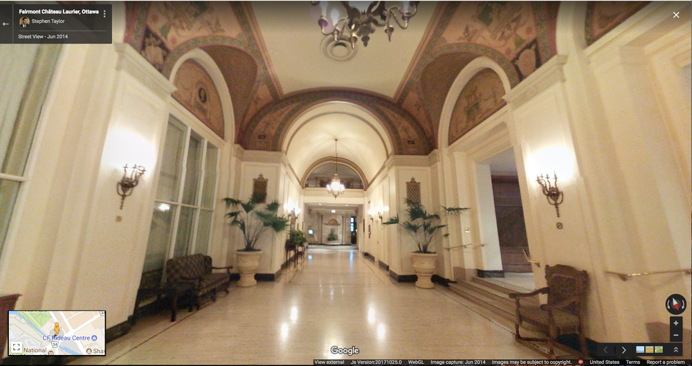
Our first stop is the Château Laurier, a 660,000-square-foot hotel that looms above the Ottawa River. Over the past 105 years, this architectural majesty has been graced by the likes of King George VI and Queen Elizabeth. But these dignitaries are not the only ones to walk its halls over the years … the restless spirit of business tycoon Charles Melville Hays has been known to appear. He commissioned the Château Laurier, but died tragically aboard the Titanic just days before the hotel’s grand opening in 1912. It's believed his spirit returned shortly after, and on occasion has been spotted roaming inside and out.

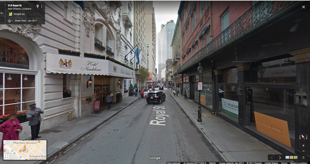
Head over to The French Quarter in New Orleans where both the living and dead are having a blood curdling good time. The soft sounds of jazz and the faint smell of beignets waft through the streets, but the dark side of this city is as rich as its melodies and cuisine—around every corner there are ghosts and vampires to be seen. Venture into Hotel Monteleone, where there have been many spooky sightings. This haunted hotel has a restaurant door that opens almost every evening then closes again (even though it’s locked) and an elevator that stops on the wrong floor, leading down a hallway that grows chilly and reveals the ghostly images of children playing. Stay there if you dare—you won’t know when to expect the next surprise.

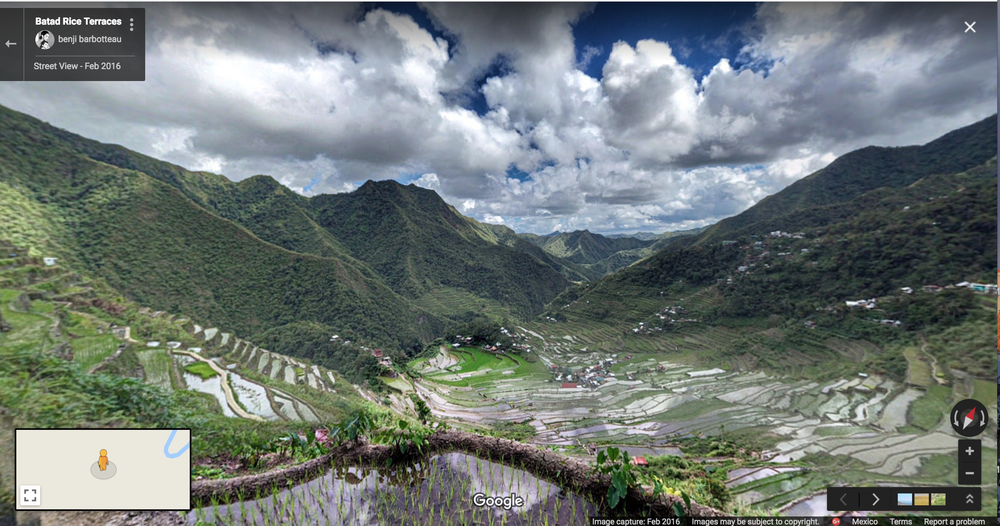
Now let’s head to the lush green paradise on Oman Island in the Philippines. Don’t let the beautiful landscape deceive you—this place has its fair share of spirits known to pester passers by. Local lore claims there are travelers who trek in circles, never finding their way out … and travelers have reported suddenly feeling weight on their backs, almost as if local ghosts are hunched on their shoulders.

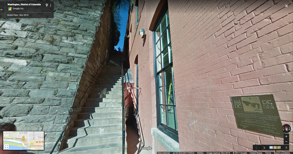
If iconic horror films are your jam, head on over to Georgetown, Washington, D.C., where the Exorcist was filmed. In “The Exorcist,” the character Father Damien Karras fell to his death down  this flight of stairs (though they were padded with half an inch of rubber). The film crew had to construct a false front to the house from which Karras fell, since the actual house was set back slightly from the steps. When the filming took place, Georgetown University students charged people $5 each to watch the stunt from the school’s rooftops.

“Let the Right One In” is a Swedish film about a bullied 12-year-old boy who befriends a vampire child in Blackeberg, Stockholm, in the early 1980s. Check out the town square of Blackeberg

https://en.wikipedia.org/wiki/Blackeberg

, where Eli the vampire leaps down on Virginia from a tree.


That completes our tour, but beware of spooky things of which you may not be forewarned— for this is Halloween!

Source: Google LatLong


Making search results more local and relevant

When you’re searching on Google, we aim to provide the most useful results for your query. Today, around one in five searches on Google is related to location, so providing locally relevant search results is an essential part of serving you the most accurate information.


In order to provide this optimal experience, your location determines the country service you receive results for across Google Search and Maps. Historically, these services have been labeled and accessed via country code top level domain names (ccTLD) such as [google.ng for Nigeria] or [google.com.br for Brazil]. You may also have typed in the relevant ccTLD in your browser.


Today, we’ve updated the way we label country services on the mobile web, the Google app for iOS, and desktop Search and Maps. Now the choice of country service will no longer be indicated by domain. Instead, by default, you’ll be served the country service that corresponds to your location. So if you live in Australia, you’ll automatically receive the country service for Australia, but when you travel to New Zealand, your results will switch automatically to the country service for New Zealand. Upon return to Australia, you will seamlessly revert back to the Australian country service.

domainless4.gif

If for some reason you don't see the right country when you're browsing, you can still go into settings and select the correct country service you want to receive. Typing the relevant ccTLD in your browser will no longer bring you to the various country services—this preference should be managed directly in settings. In addition, at the bottom of the search results page, you can clearly see which country service you are currently using.

NewZealand.png

It’s important to note that while this update will change the way Google Search and Maps services are labeled, it won’t affect the way these products work, nor will it change how we handle obligations under national law. This update will help ensure that you get the most relevant results based on your location and is consistent with how Google already manages our services across a number of our other platforms, including YouTube, Blogger, Google Earth and Gmail, among others.


We’re confident this change will improve your Search experience, automatically providing you with the most useful information based on your search query and other context, including location.

Source: Google LatLong


From paw prints to a digital footprint: a tailor shop attracts new customers

A chubby French Bulldog keeps watch in front of a vintage-looking tailor shop in New York City’s SoHo neighborhood. Meet Bruno, the face of Village Tailor and Cleaners. Vince, the shop’s owner, immigrated to the U.S. from Italy when he was just 18 years old, establishing Village Tailor in 1977. Today, his family-run business has grown into three locations and is best known for its skilled leather and suede alterations. Inside the shop, a wall covered in autographed photos of celebrity customers—Celine Dion, Marc Anthony, Elton John, and others—is a testament to the iconic quality of Vince's work.

photo 1.jpg
Vince and Bruno outside the shop.

While Bruno had been doing a wonderful job bringing in passersby, Vince knew he needed a way to stand out from the many tailoring shops in SoHo and reach more customers.


Vince noticed that most of his customers were walking in with a bag of clothes in one hand, and researching local businesses on their cell phone with the other. So, he decided to get his business online. He saw it as similar to Bruno sitting out front: their online presence could spark curiosity, help them stand out, and invite in new customers.

photo 2.jpg

Bruno is on the lookout for new customers ... and treats.

He set up Village Tailor's Google listing, so that he could edit how his business appears when people find it on Google Search and Maps. He added photos to his listing, posted updates about his skilled alterations, and used Google website builder to create a free high-quality website from his phone in less than 10 minutes. Now, when he asks new customers how they found his shop, they often mention Google.

Village Tailor & Cleaner v2.png

Having an online presence not only helped Vince reach new customers, but it allowed him to build relationships with his existing customers by responding to reviews. Knowing that people trust online reviews as much as personal recommendations, reviews are an opportunity to adapt his business to customers’ needs. The results have been great for Village Tailor: within weeks of getting online, Vince noticed they were bringing in on average five more customers per week. After three months, that number increased to 15 per week, representing a 30% revenue increase per year for Vince. 

The store’s early success with Google My Business inspired Vince to try AdWords, advertising to potential customers searching on Google for keywords related to tailoring. Since customers raved about the leather and suede work in Village Tailor’s Google reviews, Vince focused on those services in his online ads which brought in even more revenue. That meant he could hire more tailors and invest in new equipment to keep up with the long lines of customers. Now, while Bruno will always have a place in front of Village Tailor, Google brings in most of their customers. Sorry Bruno!

photo 3.jpg

Father and son: two generations of excellence in alterations.

Today, Vince’s son Vincent Jr. manages Village Cobbler, the shoe repair shop next door. Continuing the family business’s tradition of excellent craftsmanship in shoes and leather goods, his newest mission is to get Village Cobbler 100% online, with an eCommerce website that offers shipping all over the U.S. He also plans to find new customers with Google My Business and Google AdWords, just like his father has, to keep the family business growing.

Source: Google LatLong


From paw prints to a digital footprint: a tailor shop attracts new customers

A chubby French Bulldog keeps watch in front of a vintage-looking tailor shop in New York City’s SoHo neighborhood. Meet Bruno, the face of Village Tailor and Cleaners. Vince, the shop’s owner, immigrated to the U.S. from Italy when he was just 18 years old, establishing Village Tailor in 1977. Today, his family-run business has grown into three locations and is best known for its skilled leather and suede alterations. Inside the shop, a wall covered in autographed photos of celebrity customers—Celine Dion, Marc Anthony, Elton John, and others—is a testament to the iconic quality of Vince's work.

photo 1.jpg
Vince and Bruno outside the shop.

While Bruno had been doing a wonderful job bringing in passersby, Vince knew he needed a way to stand out from the many tailoring shops in SoHo and reach more customers.


Vince noticed that most of his customers were walking in with a bag of clothes in one hand, and researching local businesses on their cell phone with the other. So, he decided to get his business online. He saw it as similar to Bruno sitting out front: their online presence could spark curiosity, help them stand out, and invite in new customers.

photo 2.jpg

Bruno is on the lookout for new customers ... and treats.

He set up Village Tailor's Google listing, so that he could edit how his business appears when people find it on Google Search and Maps. He added photos to his listing, posted updates about his skilled alterations, and used Google website builder to create a free high-quality website from his phone in less than 10 minutes. Now, when he asks new customers how they found his shop, they often mention Google.

Village Tailor & Cleaner v2.png

Having an online presence not only helped Vince reach new customers, but it allowed him to build relationships with his existing customers by responding to reviews. Knowing that people trust online reviews as much as personal recommendations, reviews are an opportunity to adapt his business to customers’ needs. The results have been great for Village Tailor: within weeks of getting online, Vince noticed they were bringing in on average five more customers per week. After three months, that number increased to 15 per week, representing a 30 percent revenue increase per year for Vince. 

The store’s early success with Google My Business inspired Vince to try AdWords, advertising to potential customers searching on Google for keywords related to tailoring. Since customers raved about the leather and suede work in Village Tailor’s Google reviews, Vince focused on those services in his online ads which brought in even more revenue. That meant he could hire more tailors and invest in new equipment to keep up with the long lines of customers. Now, while Bruno will always have a place in front of Village Tailor, Google brings in most of their customers. Sorry Bruno!

photo 3.jpg

Father and son: two generations of excellence in alterations.

Today, Vince’s son Vincent Jr. manages Vince's Village Cobbler, the shoe repair shop next door. Building on the family business’s tradition of excellent craftsmanship in shoes and leather goods, he continues to develop Village Cobbler's online presence with an e-commerce website that offers shipping all over the U.S. He also plans to find new customers with Google My Business and Google AdWords, just like his father has, to keep the family business growing. 

Source: Google LatLong


Space out with planets in Google Maps

Twenty years ago, the spacecraft Cassini launched from Cape Canaveral on a journey to uncover the secrets of Saturn and its many moons. During its mission, Cassini recorded and sent nearly half a million pictures back to Earth, allowing scientists to reconstruct these distant worlds in unprecedented detail. Now you can visit these places—along with many other planets and moons—in Google Maps right from your computer. For extra fun, try zooming out from the Earth until you're in space!

Moons 1

Explore the icy plains of Enceladus, where Cassini discovered water beneath the moon's crust—suggesting signs of life. Peer beneath the thick clouds of Titan to see methane lakes. Inspect the massive crater of Mimas—while it might seem like a sci-fi look-a-like, it is a moon, not a space station.  

3

Special thanks goes to astronomical artist Björn Jónsson, who assembled the planetary maps of Europa, Ganymede, Rhea, and Mimas by working with imagery from NASA and the European Space Agency.

The fun doesn't stop there—we've added Pluto, Venus, and several other moons for a total of 12 new worlds for you to explore. Grab your spacesuit and check out the rest of this corner of the galaxy that we call home.

Source: Google LatLong


Street View goes to the “top of the world”

Editor’s Note: Today’s post comes from Emma Upton, Quttinirpaaq National Park Manager with Parks Canada. She shares the story behind our new Street View collection that captures the beauty of Canada’s Quttinirpaaq National Park.

Here at Parks Canada, we have a lot to say about Quttinirpaaq National Park. We could tell you it’s the northernmost park in Canada, or that it lies roughly 500 miles (800 kilometers) from the North Pole. We could tell you it’s home to 4000-year-old archeologist sites or that it’s the second-largest national park in the country. But, we don’t need to tell you anymore. Now we can show you, with our new Street View collection.

Last summer, our team threw on the Google Trekker and explored the park’s incredible terrain—it was the furthest north Street View has ever gone. Wilderness and extreme isolation characterize this area, where fewer than 50 people visit each year. The park’s name itself translates to “the top of the world” in Inuktitut, the local indigenous language.

Google Street View in Quttinirpaaq National Park and Grise Fiord, Nunavut

With treks along the ocean shoreline, climbs up to lofty ridges, strolls beside glacial melt-water rivers, and scrambles at the foot of monumental glaciers, the resulting imagery is spectacular—a digital reflection of one of the world’s most rural locations

Aside from Quttinirpaaq National Park, we captured Street view imagery of Grise Fiord, Canada’s northernmost community, and Resolute Bay, which has a population of just under 200 people.

Internet access and bandwidth are challenging in this part of the world, but we wanted the people who live in and around the area to be able to enjoy the new Street View collection. We revealed the imagery, as well as the behind-the-scenes story of how it was captured, at an event hosted by Parks Canada. And we were moved to see how excited people were to see their remote home online for the world to explore.

See all the highlights in this gallery, and a few photos of our trek below:

Source: Google LatLong


The Agoraphobic Traveller shares her Street View portraits

Editor’s note: Jacqui Kenny is a New Zealander who now lives in London, U.K. On World Mental Health Day, we asked Jacqui to tell her story about a surprising use of Street View.


For over 20 years I have lived with severe anxiety, and eight years ago I was diagnosed with agoraphobia. Agoraphobia is an anxiety disorder in which you fear and avoid places or situations where you might feel panicked, trapped, helpless or embarrassed. Sometimes walking to my local supermarket can be a challenge, let alone traveling far from home.


Almost two years ago, after closing down a decade-old business I had co-founded, I lost confidence in myself, and my agoraphobia worsened. I wasn’t ready to face the world, but I knew I needed a creative outlet to help keep the negative thoughts away.


I found a surprising and unique refuge in the creative possibilities of Google Street View. As I clicked through Google Maps, I left my London home and navigated the streets of faraway countries like Mongolia, Senegal, and Chile. I encountered remote towns and dusty landscapes, vibrant architectural gems, and anonymous people, all frozen in time. The more I traveled, the more I found scenes that appeared to be plucked from a strange and expansive parallel universe. What began as a hobby quickly became a pursuit of the hidden, magical realms of Street View.


I began to take thousands of screenshots of these dreamlike scenarios; to date I’ve taken 27,000 screenshots. I realized that the billions of photographs that Google captured for functional purposes were ripe for creativity. And when framed and angled with care, they could be as beautiful and emotional as traditional photography. I had found a way to experience places across the world that I had long yearned to explore but would find hard to travel to in real life.

agoraphobic traveler

I started to upload my images to Instagram, where I found a supportive community of both creatives and people that share similar struggles with mental health and anxiety disorders. I receive messages daily from people that want to share their own stories with me.


The community I had built around my photos helped embolden me to go outside my comfort zone. When I was offered the opportunity to have a solo exhibition in Nolita, New York, I got on a plane for the first time in many years years. I was offered the opportunity to have a solo exhibition in New York, NY. The Agoraphobic Traveller exhibition showcases a series of my favorite images, as well as a series of 360 experiences that help explain my process. On opening night, hundreds of people turned up to show their support, many from my Instagram community. It was a night I’ll never forget.


World Mental Health Day, October 10, is a time to raise awareness of mental health issues around the world. By telling my story and sharing my own experiences, I want to help de-stigmatize and normalize the conversation around mental health. I hope my journey will encourage others not only to open up and talk about their mental health struggles but also to look for creative ways to get through the tough moments.


If you want to say hi or see more of my work, you can find me on Instagram.

Source: Google LatLong


The economic impact of geospatial services

With Google Maps, we’re committed to creating a rich, deep, and detailed understanding of the world. By digitizing and providing access to a wealth of information about the real world, we allow people to easily explore the world around them, provide tools for businesses to attract and connect with customers, power map and location experiences for third party apps and websites, and enable NGOs and governments to leverage our map and resources to tackle real-world challenges like urban planning or emergency response.

Google is continually looking for ways to add value––for our users, for local businesses, and for our partners across many industries. We want to stretch people’s perceptions of what a map can do for them, of the types of questions we can answer about the world, and the tasks we can help with. And to do that, we need to understand maps today and the impact they have on people’s lives.

With this in mind, we commissioned a detailed study to look at the impact of the geospatial industry—the ecosystem of industries that rely on geospatial technology (both online and offline)—and the direct benefit it provides to people, businesses and society. We worked with AlphaBeta, a strategy advisory business, to analyze the global impact of the geospatial industry in 2016. We asked AlphaBeta to highlight some of their findings and the methodology behind them. — Jen Fitzpatrick, VP Google Maps


At AlphaBeta, we’re passionate about identifying the forces shaping global markets and developing practical plans to create prosperity and well-being. We believe that geospatial technology is one of these forces, which is why we recently undertook research, commissioned by Google, to evaluate the impact of digital maps and their underlying technologies.

We asked ourselves: what is the full value of digital maps for users? How is this technology affecting the broader economic environment? How can societies make the most out of it?

We used consumer surveys across 22 countries spanning six regions, and other estimation approaches (such as big data analysis of online job postings), and found that geospatial services make an impact in three key ways:

Geospatial1

Consumer benefits
Maps help people move and shop in a faster and more efficient way. For example, not only do digital maps reduce travel time, they also help people save time on purchases by providing information like directions and product availability. By helping people plan routes in areas they aren’t familiar with, maps also improve public safety.

Geospatial2
Business benefits

Maps help make small and large businesses more visible, productive and profitable. By providing useful facts such as store hours, contact information and reviews, maps help drive sales—particularly important for small businesses that may find potential new customers without incurring additional advertising costs. Geospatial services also play a strategic role in helping companies in sectors covering approximately three quarters of the world’s GDP raise revenues and/or diminish costs. For example, retail companies use digital maps for market research and to identify the most profitable locations for their network of stores.

Geospatial3
Societal benefits

Finally, maps have positive spillover effects on the environment and societies around the world—for example, by creating jobs and reducing CO2 emissions through more efficient vehicle trips and easier identification of alternative transportation options. Geospatial technology can also play a role in emergencies—such as helping people prepare for a natural disaster by highlighting flood-risk areas.

The impact of geospatial services also varies from country to country—showing that there’s still room in many places to maximize the benefits of geospatial services for everyone. To do so, the geospatial industry, businesses, NGOs and governments in these areas will need to work together to promote, adopt and implement existing and new applications of geospatial technology.

To find out more, visit www.valueoftheweb.com.


Source: Google LatLong


A ride to remember on World Alzheimer’s Day

Editor's note: Anne-Christine Hertz is a Swedish inventor who works at Health Technology Centre of Halland. Today, she shares a story of how the Centre used Street View to invent a device that helps elderly with Alzheimer’s.

A few weeks ago I met 75-year-old Lars Jonsson and his wife Ingrid. They married when Lars was 40 and have lived a happy, fulfilling life together. Lars also suffers from dementia.

Every three seconds someone develops dementia, a condition that creates disability and dependency among many elderly, robbing them of memory and judgment. It's not only overwhelming and stressful for those suffering, but also their loved ones. It was tough on Ingrid when her husband suddenly had trouble recalling the memories they’d spent a lifetime creating.

We met Lars and Ingrid when they came to test a device we invented to improve the lives of dementia patients. It’s called BikeAround, and it pairs a stationary bike with Google Street View projected on a big screen to take patients on a virtual ride down memory lane, letting them pedal around a place they have visited in the past. As Lars sat in the saddle, Ingrid suggested we take him back to the city and church in which they got married. Lars’s face flickered with happiness as the church rose up before him. The expression on his wife’s face when she knew for sure that he remembered was heartwarming

The development of the BikeAround system, which is now owned by health care company Camanio Care, started back in 2010 at Health Technology Center in Halland, Sweden. We were conducting research on dementia, and noticed people living with the disease were given different access to physical activity depending on which municipality they were living in. Since it’s often recommended that dementia patients perform physical activities to stimulate both physical and mental health, this was an issue. We wanted to find a way to motivate the elderly with dementia to exercise more, in a safe and secure way.

Dementia patient Bengt and his wife Laila test the BikeAround system.

Our strongest memories are tied inexorably to location. It’s no coincidence, when you think about any big memory or past event, your first thought is often “Where was I when that happened?” BikeAround taps into this idea by combining mental and physical stimulation—surrounding the patient with places they recognize through the Street View images, and then having them pedal and steer through them. Scientists think this kind of pairing produces dopamine in the brain and has the potential to affect memory management in a profound way.

Today is World Alzheimer’s Day, a time when people and organizations from all over the world concentrate their efforts on raising awareness of this disease for which there’s no cure. Researchers all over the world are trying to find new ways to increase quality of life for the people affected by the disease. The experience with Lars—and many others patients—proves we’ve developed not just a product for improving health, but something that creates emotion and connects people. Patients often find the BikeAround solution so fascinating—so comforting—they don’t want to get off. Neighborhoods they grew up in. Parks they played in as a child. Family visits to the seaside. They remember again. That’s a feeling of freedom.

Copy of 170609_D3_046.jpg
Bengt Ivarsson tests BikeAround, a stationary bike that’s paired with Google Street View to take dementia patients on a virtual ride down memory lane.

I have always looked at digitization and technology as a catalyst to open up the world not just to the tech savvy, but also to the elderly, who often live in digital exclusion. We’re excited about having found a way to bring happiness to many people living with dementia and their relatives. But what's also exciting to me is that this is just one example of how technology can be harnessed to make a real impact on people's lives. If we look beyond ourselves and unleash our imaginations, there's no limit to what we can do to help others.

Source: Google LatLong


A better world for wheels on Google Maps

More than 65 million people worldwide need wheelchairs. I became one of them after an accident eight years ago, and I discovered what it’s like to navigate the world on wheels.

As I learned, those of us with mobility issues need information about places before we arrive. Does the art museum have a stair-free entrance? What about the cafe across the street? And is there an accessible restroom at that new restaurant?

Google Maps now offers answers that allow me—and millions of others on wheels—to find accessible places. Because anyone can identify and label wheelchair-friendly locations directly on the map, it’s easy to share this knowledge around the world. But not everyone knows this tool exists, so we want to do more.

Starting today, we’re calling on Local Guides, a community of people who contribute their expertise about places on Google Maps, to add more wheelchair accessibility attributes to the map. If each of our tens of millions of Local Guides answers three of these questions every day for two weeks, we can gather nearly two billion answers to help people who rely on this information every day.

And wheelchair users aren’t the only ones who will benefit. You'll also be making life easier for families with strollers, seniors with walkers, or anyone making plans with a friend who has impaired mobility.

It takes seconds to have this type of impact. First, make sure your Google Maps Location History is turned on. Then visit “Your contributions” in the upper-left menu, tap “Answer questions about a place,” and indicate whether businesses you’ve visited are wheelchair-friendly. (If you aren’t sure, take a look at a brief guide to answering accessibility questions.) On Google Maps for Android, you can even seek out places that need this info.

Manifesting

All month, Local Guides across the globe are getting together at meet-ups to answer wheelchair accessibility questions on Google Maps. Join a meet-up, or even host your own (if you’re a Local Guide Level 3 or higher). Or gather some friends and explore a neighborhood, adding info as you go.

We hope you’ll contribute your knowledge to the map to help those of us on wheels more easily navigate the world.

Spread the word using #LocalGuides and #a11y.

Source: Google LatLong