Category Archives: Geo Developers Blog

Google Geo Developers Blog

Address Geocoding in the Google Maps APIs

Forward Geocoding is the process of converting addresses (like a street address) into geographic coordinates (latitude and longitude), which you can use to place markers on a map or position the map. The Google Maps APIs have several services that you can use to convert addresses into coordinates - the Geocoding API, the Place Autocomplete service in Places API, and the Place Search service in Places API. What are the differences between them and when should you use each one? Here’s where to start.


Note that while this blog focuses on the server-side Places and Geocoding APIs, these best practices also apply to the client-side Places and Geocoding services in the Google Maps JavaScript API.


Geocoding API


The Geocoding API is best for handling unambiguous queries: complete postal address strings (for example, “48 Pirrama Rd, Pyrmont, NSW, Australia”). Compared to other Google APIs, the Geocoding API provides the best quality matching of addresses globally for these types of complete, unambiguous queries. However, Geocoding API is not recommended if your application handles ambiguous or incomplete queries, such as “123 Main St”, or if it handles queries that may contain non-address information such as apartment numbers or business names.


Screen Shot 2016-11-15 at 6.16.15 PM.png
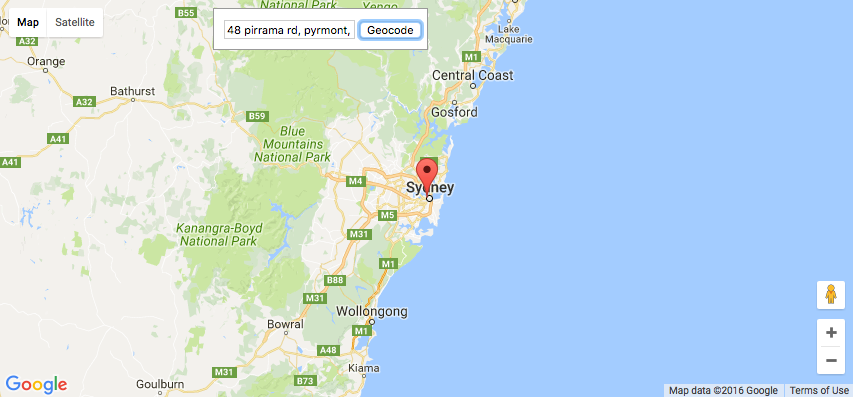
Geocoding API is best used for unambiguous complete addresses, such as "48 Pirrama Rd, Pyrmont, NSW, Australia" 


Places API


The Places API allows users to discover both addresses and semantic locations, such as cafes or parks, by name or type. In contrast to the Geocoding API, it handles ambiguous or incomplete requests in a more robust way. If your application handles user interaction, or addresses that are ambiguous or incomplete, consider the following services.


Place Autocomplete service


For applications that respond in real time to user input, we recommend using the Place Autocomplete service in the Places API. This service is designed to return multiple possible addresses and allow the user to choose between them. The autocomplete lookup function can also be biased to return results specific to a location, enabling high quality results to be returned for incomplete queries such as “123 Main St”. Since the Place Autocomplete service is optimized for responding to user input, it also has very low latency, usually at least 10x lower than the Geocoding API. It’s also good at handling misspelled queries, or queries containing non-address information, since as the user types, they can see suggestions and correct their spelling if needed.


Screen Shot 2016-11-14 at 5.35.53 PM.png
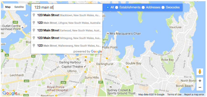
Typing "123 Main St" into a Place Autocomplete search box lets the user choose from multiple results. Results can also be biased to prefer those near the area shown on the map or near the current user location


Place Search service


The Place Autocomplete service relies on a user to choose the best option from multiple results. What if you have an application that handles ambiguous or incomplete queries in an automated fashion, with no user able to provide input?


For geocoding ambiguous or incomplete addresses in automated systems, when there is no user to select one of the autocomplete suggestions, we recommend the Place Search service in Places API. Place Search is better at coping with ambiguous queries than the Geocoding API, and lets you restrict your search to a specified area, or rank results by distance, allowing more precise filtering and ranking of results for ambiguous or incomplete queries. Place search is also more robust at responding to queries with additional non-address information such as business names or apartment numbers.


Future Changes to Geocoding API


We plan to roll out an update to the Geocoding API at the end of November 2016 that will increase the difference between Geocoding and Places performance for ambiguous and unambiguous queries. This change will improve the quality of Geocoding results for unambiguous queries, but will be more likely to return ZERO_RESULTS for ambiguous or incomplete queries where the Geocoding API was unable to find a high quality result.


If you are already using the above best practices, you should see an improvement in your Geocoding API results. If you are currently using the Geocoding API for incomplete or ambiguous queries, or for queries that may contain non-address information such as business names or apartment numbers, we recommend that you switch to the Places API instead, as it is likely to give better quality results for your use case.


You can try the new Geocoding service ahead of launch by adding an optional parameter, new_forward_geocoder=true, to your Geocoding API request. For example:


https://maps.googleapis.com/maps/api/geocode/json?new_forward_geocoder=true&address=1600+Amphitheatre+Parkway,+Mountain+View,+CA&key=YOUR_API_KEY


If you want to try the new Geocoding service in the JavaScript Maps API Geocoding Service, you can set the new optional parameter newForwardGeocoder: true in the GeocoderRequest object. The new Geocoding service will launch for both the Geocoding API and the Geocoding Service in the JavaScript Maps API at the same time. All of the recommendations in this blog post apply to both the server-side and client-side APIs.


If you have any bug reports or feature requests for the new Geocoding service, please let us know using our public issue tracker.


In Summary


The following table sums up when we recommend you use the Geocoding API, Place Autocomplete service and Place Search service.


Geocoding API Place Search Place Autocomplete
Scope Addresses only Semantic locations and addresses, including businesses and points of interest
Strengths Unambiguous complete addresses Ambiguous or incomplete addresses in automated systems Responding to real-time user input


If your application does not yet follow these best practices, you may get worse results from Geocoding API in future, so we recommend you test how your application works with the new Geocoding service and update your application to use the above best practices if required. Try the upcoming Geocoding service by setting new_forward_geocoder=true in your geocoding request.


For more information on the Google Maps Geocoding API, Place Autocomplete in the Places API and Place Search in the Places API, please see the developer documentation. Also see this more detailed best practices guide in our documentation for more details on Geocoding best practices for various use cases, including minimizing latency when querying Directions API with addresses.


Finally, a big thank you to all the developers who use the Google Maps Geocoding API and provide feedback via the issue tracker. Getting feedback from developers is vital for us to be able to keep improving our products, so if you have any bug reports or feature requests, please let us know!


author image

Posted by Elena Kelareva, Product Manager, Google Maps APIs

Smart scrolling comes to mobile web maps

If you’re building a website today, your users are more likely to view it on a mobile device than on a desktop or laptop. Google has plenty of resources to help developers make their websites stand out on mobile, from a guide to building mobile-friendly websites, to a mobile-friendly testing tool, to promoting new mobile web technologies such as Accelerated Mobile Pages and Progressive Web Apps.
bullheadN5D91Lstephenmcd11092016101027.gif

Mobile web users often get frustrated when trying to scroll the page, but an embedded map captures their swipe and pans the map instead. This can even lead to users getting stuck on the map and having to reload the page in order to get back to the rest of the page.

Today we're introducing intuitive scrolling for sites with embedded maps and making the full-screen control visible by default on mobile devices. This should give your users a more intuitive and less frustrating map interaction experience on mobile browsers.

The map trap

We have added a new gestureHandling option to the Google Maps JavaScript API. This setting controls how touch gestures* on the map are handled.

Values:
  • "cooperative": Two-finger touch gestures pan and zoom the map, as do all mouse gestures. One-finger touch gestures are ignored by the map. In this mode, the map cooperates with the page, so that one-finger touch gestures can pan the page.
  • "greedy": All touch gestures pan or zoom the map. This was the previous behaviour.
  • "none": The map cannot be panned or zoomed by user gestures.
  • "auto": Gesture handling is automatically set to either cooperative or greedy, depending on whether the page is scrollable or not (defined by a comparison of the page body dimensions and the window dimensions).
  • If the page is scrollable, “auto” sets the gesture handling mode to cooperative.
  • If the page is not scrollable, “auto” sets the gesture handling to greedy.
  • If the map is in an iFrame, “auto” sets the gesture handling to cooperative because the API can’t determine whether the page is scrollable.
*Note that there is currently no way to change the gesture handling mode for Street View; these options only affect the way gestures are handled by the map. If you’d like to see this extended to Street View in future, please let us know on our public issue tracker.
    You can enable any of these four gesture handling modes by adding the corresponding field to the MapOptions object. For example:

    map = new google.maps.Map(document.getElementById('map-div'), {
    gestureHandling: 'cooperative',
    center: {lat: -34.397, lng: 150.644},
    zoom: 8
    });

    If the gestureHandling option is not set, the default value is auto, since that automatically chooses what we expect to be the best behavior based on what the browser can detect about the placement of your map in the page. If you prefer to always use the old map gesture handling mode for users viewing your site on mobile devices, change the value of gestureHandling to greedy, which sends all user gestures to the map.
    Maps viewed within a scrollable website on a mobile device will display this overlay on touch
    The option draggable: false has now been superseded by gestureHandling: 'none'. The old option draggable is now deprecated, but we’ll maintain backwards compatibility. Developers who previously turned off map interaction by setting draggable to false will keep their existing non-interactive maps.

    Maximizing the map when you need it

    Many users in our user studies said they found small embedded maps on mobile devices hard to interact with and they preferred to interact with a larger map. To address this request, we've made the fullscreen control visible by default on mobile devices. The fullscreen control allows the user to make the map larger. When the map is in fullscreen mode, the user can pan the map using one finger. As a developer, you can enable or disable fullscreen control, by setting the fullscreenControl option to true or false in the MapOptions object. When the map is in fullscreen mode, one finger will always pan the map, since there is no surrounding page to pan.

    The default setting of fullscreenControl is true on mobile browsers, and false on desktop browsers, since the problem of maps being too small for interaction usually only occurs on mobile devices.
    ScrollLockScreenshot.png
    The fullscreen control allows the user to make the map larger for easier interaction
    View this demo on a mobile device to see how the fullscreen button and cooperative gesture handling mode (or auto gesture handling mode on a scrollable site) will look to your users.

    For more information on the Google Maps JavaScript API, please see the developer documentation or review the latest release notes.

    A big thank you to all the developers who use the Google Maps JavaScript API and provide feedback via the issue tracker. Getting feedback from developers is vital for us to be able to keep improving our products, so if you have any bug reports or feature requests, please let us know.

    author image
    Posted by Elena Kelareva, Product Manager, Google Maps APIs

    Smart scrolling comes to mobile web maps

    If you’re building a website today, your users are more likely to view it on a mobile device than on a desktop or laptop. Google has plenty of resources to help developers make their websites stand out on mobile, from a guide to building mobile-friendly websites, to a mobile-friendly testing tool, to promoting new mobile web technologies such as Accelerated Mobile Pages and Progressive Web Apps.

    bullheadN5D91Lstephenmcd11092016101027.gif


    Mobile web users often get frustrated when trying to scroll the page, but an embedded map captures their swipe and pans the map instead. This can even lead to users getting stuck on the map and having to reload the page in order to get back to the rest of the page.


    Today we're introducing intuitive scrolling for sites with embedded maps and making the full-screen control visible by default on mobile devices. This should give your users a more intuitive and less frustrating map interaction experience on mobile browsers.


    The map trap

    We have added a new gestureHandling option to the Google Maps JavaScript API. This setting controls how touch gestures* on the map are handled.


    Values:

    • "cooperative": Two-finger touch gestures pan and zoom the map, as do all mouse gestures. One-finger touch gestures are ignored by the map. In this mode, the map cooperates with the page, so that one-finger touch gestures can pan the page.

    • "greedy": All touch gestures pan or zoom the map. This was the previous behaviour.

    • "none": The map cannot be panned or zoomed by user gestures.

    • "auto": Gesture handling is automatically set to either cooperative or greedy, depending on whether the page is scrollable or not (defined by a comparison of the page body dimensions and the window dimensions).

    • If the page is scrollable, “auto” sets the gesture handling mode to cooperative.

    • If the page is not scrollable, “auto” sets the gesture handling to greedy.

    • If the map is in an iFrame, “auto” sets the gesture handling to cooperative because the API can’t determine whether the page is scrollable.

    *Note that there is currently no way to change the gesture handling mode for Street View; these options only affect the way gestures are handled by the map. If you’d like to see this extended to Street View in future, please let us know on our public issue tracker.

      You can enable any of these four gesture handling modes by adding the corresponding field to the MapOptions object. For example:


      map = new google.maps.Map(document.getElementById('map-div'), {

      gestureHandling: 'cooperative',

      center: {lat: -34.397, lng: 150.644},

      zoom: 8

      });


      If the gestureHandling option is not set, the default value is auto, since that automatically chooses what we expect to be the best behavior based on what the browser can detect about the placement of your map in the page. If you prefer to always use the old map gesture handling mode for users viewing your site on mobile devices, change the value of gestureHandling to greedy, which sends all user gestures to the map.


      Maps viewed within a scrollable website on a mobile device will display this overlay on touch
      The option draggable: false has now been superseded by gestureHandling: 'none'. The old option draggable is now deprecated, but we’ll maintain backwards compatibility. Developers who previously turned off map interaction by setting draggable to false will keep their existing non-interactive maps.


      Maximizing the map when you need it

      Many users in our user studies said they found small embedded maps on mobile devices hard to interact with and they preferred to interact with a larger map. To address this request, we've made the fullscreen control visible by default on mobile devices. The fullscreen control allows the user to make the map larger. When the map is in fullscreen mode, the user can pan the map using one finger. As a developer, you can enable or disable fullscreen control, by setting the fullscreenControl option to true or false in the MapOptions object. When the map is in fullscreen mode, one finger will always pan the map, since there is no surrounding page to pan.


      The default setting of fullscreenControl is true on mobile browsers, and false on desktop browsers, since the problem of maps being too small for interaction usually only occurs on mobile devices.


      ScrollLockScreenshot.png
      The fullscreen control allows the user to make the map larger for easier interaction
      View this demo on a mobile device to see how the fullscreen button and cooperative gesture handling mode (or auto gesture handling mode on a scrollable site) will look to your users.


      For more information on the Google Maps JavaScript API, please see the developer documentation or review the latest release notes.


      A big thank you to all the developers who use the Google Maps JavaScript API and provide feedback via the issue tracker. Getting feedback from developers is vital for us to be able to keep improving our products, so if you have any bug reports or feature requests, please let us know.


      author image
      Posted by Elena Kelareva, Product Manager, Google Maps APIs


      Key Improvements for Your Maps API Experience

      Originally posted on the Google Developers blog.
      Posted by Israel Shalom, Product Manager

      Here at Google, we’re serving more than a hundred APIs to ensure that developers have the resources to build amazing experiences with them. We provide a reliable infrastructure and make it as simple as possible so developers can focus on building the future. With this in mind, we’re introducing a few improvements for the API experience: more flexible keys, a streamlined 'getting-started' experience, and easy monitoring.

      Faster, more flexible key generation

      Keys are a standard way for APIs to identify callers, and one of the very first steps in interacting with a Google API. Tens of thousands of keys are created every day for Google APIs, so we’re making this step simpler -- reducing the old multi-step process with a single click:


      You no longer need to choose your platform and various other restrictions at the time of creation, but we still encourage scope management as a best practice:

      Streamlined getting started flow

      We realize that many developers want to get straight to creation and don’t necessarily want to step into the console. We’ve just introduced an in-flow credential set up procedure directly embedded within the developer documentation:

      Click the 'Get a Key' button, choose or create a project, and then let us take care of enabling the API and creating a key.
      We are currently rolling this out for the Google Maps APIs and over the next few months we'll bring it to the rest of our documentation.

      API Dashboard

      We’re not just making it easier to get started, we’re simplifying the on-going usage experience, too. For developers who use one or more APIs frequently, we've built the new API Dashboard to easily view usage and quotas.

      If you’ve enabled any APIs, the dashboard is front and center in the API Console. There you can view all the APIs you’re using along with usage, error and latency data:


      Clicking on an API will jump to a detailed report, where you’ll see the traffic sliced by methods, credentials, versions and response code (available on select APIs):


      We hope these new features make your API usage easier, and we can't wait to see what you’re going to build next!

      Key Improvements for Your Maps API Experience

      Originally posted on the Google Developers blog.

      Posted by Israel Shalom, Product Manager


      Here at Google, we’re serving more than a hundred APIs to ensure that developers have the resources to build amazing experiences with them. We provide a reliable infrastructure and make it as simple as possible so developers can focus on building the future. With this in mind, we’re introducing a few improvements for the API experience: more flexible keys, a streamlined 'getting-started' experience, and easy monitoring.


      Faster, more flexible key generation


      Keys are a standard way for APIs to identify callers, and one of the very first steps in interacting with a Google API. Tens of thousands of keys are created every day for Google APIs, so we’re making this step simpler -- reducing the old multi-step process with a single click:


      You no longer need to choose your platform and various other restrictions at the time of creation, but we still encourage scope management as a best practice:


      Streamlined getting started flow


      We realize that many developers want to get straight to creation and don’t necessarily want to step into the console. We’ve just introduced an in-flow credential set up procedure directly embedded within the developer documentation:


      Click the 'Get a Key' button, choose or create a project, and then let us take care of enabling the API and creating a key.


      We are currently rolling this out for the Google Maps APIs and over the next few months we'll bring it to the rest of our documentation.


      API Dashboard


      We’re not just making it easier to get started, we’re simplifying the on-going usage experience, too. For developers who use one or more APIs frequently, we've built the new API Dashboard to easily view usage and quotas.


      If you’ve enabled any APIs, the dashboard is front and center in the API Console. There you can view all the APIs you’re using along with usage, error and latency data:


      Clicking on an API will jump to a detailed report, where you’ll see the traffic sliced by methods, credentials, versions and response code (available on select APIs):


      We hope these new features make your API usage easier, and we can't wait to see what you’re going to build next!

      A sizzling open source release for the Australian Election site

      One of the best parts of my job at Google is 20 percent time. While I was hired to help developers use Google’s APIs, I value the time I'm afforded to be a student myself—to learn new technologies and solve real-world problems. A few weeks prior to the recent Australian election an opportunity presented itself. A small team in Sydney set their sights on helping the 15 million voters stay informed of how to participate, track real-time results, and (of course) find the closest election sausage sizzle!
      Our team of designers, engineers and product managers didn't have an immediate sense of how to attack the problem. What we did have was the power of Google’s APIs, programming languages, and Cloud hosting with Firebase and Google Cloud Platform.

      The result is a mish-mash of some technologies we'd been wanting to learn more about. We're open sourcing the ausvotes.withgoogle.com repository to give developers a sense of what happens when you get a handful of engineers in a room with a clear goal and a immovable deadline.

      The Election AU 2016 repository uses:

      • Go from Google App Engine instances to serve the appropriate level of detail for users' viewport queries from memory at very low latency, and
      • Dart to render the live result maps on top of Google Maps JavaScript API using Firebase real time database updates.

      A product is only as good as the attention and usage is receives. Our team was really happy with the results of our work:

      • 406,000 people used our maps, including 217,000 on election day.
      • We had 139 stories in the media.
      • Our map was also embedded in major news websites, such as Sky News.

      Complete setup and installation instructions are available in the Github README.

      author image
      Posted by Brett Morgan, Developer Programs Engineer

      A sizzling open source release for the Australian Election site

      One of the best parts of my job at Google is 20 percent time. While I was hired to help developers use Google’s APIs, I value the time I'm afforded to be a student myself—to learn new technologies and solve real-world problems. A few weeks prior to the recent Australian election an opportunity presented itself. A small team in Sydney set their sights on helping the 15 million voters stay informed of how to participate, track real-time results, and (of course) find the closest election sausage sizzle!


      Our team of designers, engineers and product managers didn't have an immediate sense of how to attack the problem. What we did have was the power of Google’s APIs, programming languages, and Cloud hosting with Firebase and Google Cloud Platform.


      The result is a mish-mash of some technologies we'd been wanting to learn more about. We're open sourcing the ausvotes.withgoogle.com repository to give developers a sense of what happens when you get a handful of engineers in a room with a clear goal and a immovable deadline.


      The Election AU 2016 repository uses:


      • Go from Google App Engine instances to serve the appropriate level of detail for users' viewport queries from memory at very low latency, and

      • Dart to render the live result maps on top of Google Maps JavaScript API using Firebase real time database updates.


      A product is only as good as the attention and usage is receives. Our team was really happy with the results of our work:


      • 406,000 people used our maps, including 217,000 on election day.

      • We had 139 stories in the media.

      • Our map was also embedded in major news websites, such as Sky News.


      Complete setup and installation instructions are available in the Github README.


      author image

      Posted by Brett Morgan, Developer Programs Engineer

      Custom map styling with the Google Maps APIs on Android and iOS


      Your app, your map style. For iOS and Android.


      Cross-platform custom map styling is here—change the color palette of your maps, hide labels, vary road density and toggle points of interest. Your maps can now match your brand and style across your website and your apps!


      The Google Maps APIs now support you in creating beautiful styled maps for your Android and iOS apps as well as your website using the same JSON style object.


      Easily create your style


      The new Google Maps APIs Styling Wizard helps you to create a map style in a few clicks. Use one of our pre-built styles or create your own style from scratch.


      Access advanced options for further control over every available aspect of your map style including visibility, fills & stroke weight.


      Use the styling wizard for point and click custom style creation.


      Show what’s important, hide the rest


      Custom map styling provides you with ways to tailor your map for a particular use case. Got your own transit stops and want to turn the Google ones off? We’ve got you covered. Want to hide highways and highlight water features? Done. You can control the visibility of labels, landscapes, transit icons, points of interest, roads and more to create the look that reflects your brand and purpose. See the samples for Android, iOS and JavaScript.


      Both the iOS and the Android SDKs now support business points of interest as well; this means you’ll now see hotels, restaurants and shops on your maps. They’ll only be visible when you compile with the latest SDKs and you can control their visibility via styling.


      Style once, use on any platform


      When you’re happy with your new map style, you can export & use the same JSON styling object in our iOS, Android and JavaScript Maps APIs. The Styling Wizard also provides the URL for you to use with the Google Static Maps API.


      To enable a custom style in your app or website, take a look at the code samples: Android, iOS & JavaScript.


      You can distribute the styles with your app, fetch them dynamically, and even change them at runtime.


      Custom styles now work on native iOS and Android apps as well as the web.


      The Android and iOS release notes contain details of bugs fixed as well as the custom basemap styling features mentioned in this post. Read the Maps APIs styling guides for Android, iOS and JavaScript, and watch the Styling your Maps Geocast (embedded below).


      A big thank you to Android and iOS developers everywhere for using the Google Maps Android API and the Google Maps SDK for iOS and submitting feedback via the issue tracker. We heard you!


      Share your styled basemaps on Twitter and G+ via #mapstyle and show us what you’ve done!


      author image Posted by Megan Boundey, Product Manager, Google Maps Mobile APIs

      Custom map styling with the Google Maps APIs on Android and iOS

      Your app, your map style. For iOS and Android.

      Cross-platform custom map styling is here—change the color palette of your maps, hide labels, vary road density and toggle points of interest. Your maps can now match your brand and style across your website and your apps!

      The Google Maps APIs now support you in creating beautiful styled maps for your Android and iOS apps as well as your website using the same JSON style object.

      Easily create your style

      The new Google Maps APIs Styling Wizard helps you to create a map style in a few clicks. Use one of our pre-built styles or create your own style from scratch.

      Access advanced options for further control over every available aspect of your map style including visibility, fills & stroke weight.

      Use the styling wizard for point and click custom style creation.

      Show what’s important, hide the rest

      Custom map styling provides you with ways to tailor your map for a particular use case. Got your own transit stops and want to turn the Google ones off? We’ve got you covered. Want to hide highways and highlight water features? Done. You can control the visibility of labels, landscapes, transit icons, points of interest, roads and more to create the look that reflects your brand and purpose. See the samples for Android, iOS and JavaScript.

      Both the iOS and the Android SDKs now support business points of interest as well; this means you’ll now see hotels, restaurants and shops on your maps. They’ll only be visible when you compile with the latest SDKs and you can control their visibility via styling.

      Style once, use on any platform

      When you’re happy with your new map style, you can export & use the same JSON styling object in our iOS, Android and JavaScript Maps APIs. The Styling Wizard also provides the URL for you to use with the Google Static Maps API.

      To enable a custom style in your app or website, take a look at the code samples: Android, iOS & JavaScript.

      You can distribute the styles with your app, fetch them dynamically, and even change them at runtime.
      Custom styles now work on native iOS and Android apps as well as the web.
      The Android and iOS release notes contain details of bugs fixed as well as the custom basemap styling features mentioned in this post. Read the Maps APIs styling guides for Android, iOS and JavaScript, and watch the Styling your Maps Geocast (embedded below).


      A big thank you to Android and iOS developers everywhere for using the Google Maps Android API and the Google Maps SDK for iOS and submitting feedback via the issue tracker. We heard you!

      Share your styled basemaps on Twitter and G+ via #mapstyle and show us what you’ve done!
      author image Posted by Megan Boundey, Product Manager, Google Maps Mobile APIs

      Making the most of the Google Maps Web Service APIs

      When it comes to app development, there can be a disconnect between the robust app we intended to build and the code we actually get into a minimum viable product. These shortcuts end up causing error conditions once under load in production.


      The Google Maps API team maintains client libraries that give you the power to develop with the confidence that your app will scale smoothly. We provide client libraries for Python, Java, and Go, which are used by thousands of developers around the world. We're excited to announce the recent addition of Node.js to the client library family.


      When building mobile applications, it is a best practice to use native APIS like Places API for Android and Places API for iOS where you can, but when you find that your use case requires data that is only available via the Google Maps APIs Web Services, such as Elevation, then using these client libraries is the best way forward.


      These libraries help you implement API request best practices such as:


      • Requests are sent at the default rate limit for each web service, but of course this is configurable.

      • The client libraries will automatically retry any request if the API sends a 5xx error. Retries use exponential back-off, which helps in the event of intermittent failures.

      • The client libraries make it easy to authenticate with your freely available API Key. Google Maps APIs Premium Plan customers can alternatively use their client ID and secret.

      • The Java and Go libraries return native objects for each of the API responses. The Python and Node.js libraries return the structure as it is received from the API.


      The client libraries can help you in a variety of ways. One of them is exposing the result sets in a format that makes most sense for the language in question. For example, the Java and Go client libraries include object hierarchies that are type-safe representations of the potential results for each API. This allows you to write code in the comfort of your editor with the knowledge that the compiler will catch any mistakes.


      With 3 million apps and websites using Google Maps APIs, we have an important tip for ensuring reliability when using web services: call APIs from a server rather than directly from Android or iOS. This secures your API key so that your quota can't be consumed by a bad actor, along with being able to add caching to handle common requests quickly.


      A server instance acts as a proxy that takes requests from your Android and iOS apps and then forwards them to the Google Maps Web Service APIs on your app’s behalf. The easiest way to create a server side proxy is using the Google Maps Web Service client libraries from Google App Engine instances. For more detail, please watch Laurence Moroney’s Google I/O 2016 session “Building geo services that scale”.


      You can learn more about the Google Maps API web services in our documentation. The easiest way to use these APIs and follow best practices is to use the Client Libraries for Google Maps Web Services. Download the client libraries for Java, Python, Go or Node.js from Github to start using them today!


      author image

      Posted by Brett Morgan, Developer Programs Engineer