Earlier today, we introduced a feature in the new Google Maps that enables you to embed a Google Map by copying and pasting an HTML snippet. Make sure you’re opted in, and then head over to Google Maps, click on the gear icon on the lower right, and give it a go.
Like the new Google Maps, embedded maps are now built for you. Your users can sign in to these maps to see relevant content, like their saved places from Google Maps. Conversely, they can also save a location from your embedded map for viewing on Google Maps for desktop or mobile.
To top it off, embedded maps are free of usage limits, so you don’t have to worry about quotas.
Finally, over the coming weeks we’ll be introducing a new ad experience we think is attractive for users of the new Google Maps embed. This new on-map design will allow relevant local businesses to connect with your users, similar to the ads you currently see in the new Google Maps and Google Maps for Mobile. As part of this release, we’ve also updated the Google Maps/Earth APIs Terms of Service to enable us to launch new APIs with advertising. Existing APIs and new APIs launched without advertising retain the requirement for Google to provide 90 days notice prior to including ads.
Happy embedding!
Posted by Ken Hoetmer, Product Manager, Google Maps API
Hi everyone! Fab Friday is back. We went into a long hiatus since the last post back in October. A lot has been happening in the last few weeks, so I thought I’d jump back on and let you know about it all. We launched:
And finally, Fab Friday isn’t complete without a video. This week we’ve got Mapping Big Data with Google's Cloud Platform, with Francesc Campoy Flores and Kurt Schwehr. Take a look:
That’s all for this week. Have a great weekend, and happy mapping!
Posted by Mano Marks, Maps Developer Relations team
While adding location-awareness to your application can bring tons of value and joy to your users, requiring them to type out full addresses or location queries often does the opposite. The Places API Autocomplete service, a feature of Google Places API and the Google Maps API v3’s Places Library, brings the same type-ahead-search technology from Google Maps to third party apps, helping you soothe some of your users’ address entry frustration.
To make autocomplete even more accurate and useful, we’re excited to announce an update that automatically biases predictions towards the user’s location based on the requester’s IP address. Now, results that are closer to the user will appear sooner in the API’s responses, saving users even more keystrokes and time. For a calendar app like Sunrise, where editing and adding locations quickly is important, this is a clear win for their users.
If you don’t want automatic location biasing via IP address, it can always be turned off by including other location biasing parameters in the autocomplete requests.
We’re also happy to announce our documentation now also includes a handy CSS guide to help developers add their own flair and style to the Autocomplete widgets.
With more accurate responses and customizability options, the Places API team is looking forward to more useful and beautiful autocomplete integrations. Please visit our developer documentation to learn more about the Places API. If you have technical questions, post them to the Google Maps API StackOverflow community, and if you have any feedback, please send it to us using the Google Maps API Issue Tracker.
Posted by Kevin Tran, Places API software engineer
A new version of Google Play services is currently rolling out to devices. You can start developing for it now using the latest Google Play services SDK along with the new Android 4.4 (KitKat) emulator. Read on to find out about the new features added for the Google Maps Android API v2.
Whether your app tracks ghost sightings, shows witch flight paths, or guides users to the nearest zombie-proof safehold, sometimes the best way to highlight important information is to de-emphasise some elements of your app. The new alpha property for Markers allows you to fade markers in and out as they become more or less important.
You can further tailor the map to your use case using the new setBuildingsEnabled() method to control the visibility of 3D buildings. This is especially useful when you want to highlight your own content. We’ve also made it possible to easily change ground overlay images with the new setImage() method.
Lastly, we’ve added an OnMapLoadedCallback callback interface to notify you when the map has finished rendering. The following example code shows how this callback can be combined with the snapshot feature to ensure the snapshot captures the fully rendered map:
We’re always interested to hear how you’re using the Maps APIs, so let us know if you’ve got something cool to show by tagging +Google Maps API on your posts (or comment right here!). For technical questions that aren’t answered in the developer documentation, check out the Google Maps developer community on Stack Overflow. Don’t forget to tell us what you’d like to see in the next release using the Google Maps API issue tracker.
Posted by Daniel Schramm, Associate Product Manager, Google Maps Mobile APIs
Fab Friday is back this week! We’re now fully into October. It’s a good time to stay indoors and code up some maps. To help you do that, we’ve got some videos you can use.
First off, for the iOS developers, I’ve got a new playlist, Getting Started with the Google Maps SDK for iOS. This goes into much greater detail than previous videos along the same lines, walking you through step by step. I cover:
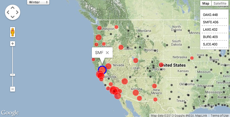
Last week Felipe and Michael from the Google Cloud Platform Developer Relations team released a video demonstrating the new Pearson correlation analysis available in Google BigQuery. Their example used more than 70 million flight records to find correlations on departure times, which could be used to predict whether your plane would be late. Specifically, you can find out which set of airports best predict your airport’s possible flight delays the following day.
As you can see from their code (watch the video for context), they’re using iPython Notebook to work with the BigQuery results, and matplotlib to get a quick visual of results. But one aspect that’s hard to see in these results is the spatial relationship of the airports. Maps to the rescue!
My goal was to create a simple visualization, where selecting any airport would highlight which airports you should look at to predict delays the next day. Using the Google Maps JavaScript API I went ahead and did just that:
To create this map, using the same code noted above, we first created a JSON dump of the correlations on departure time for each airport to each other airport. Then, using an article on visualizing earthquakes as a template, I modified the code so that we have a simple dictionary of all airports, keyed by their airport id. Last but not least, I added a function that gets called when an airport marker is clicked in order to restyle all the other airport markers according to their correlation. This method checks the selected season (winter, for example, has different correlations than spring), and highlights correlated markers by setting the color and scale of the circle symbol.
Thanks to BigQuery, running complex correlations over billions or trillions of attributes is surprisingly easy. But don’t forget if your data does have some spatial component, a quick mapping visual can add some great context to your results.
Posted by Josh Livni Maps Developer Relations Team
This week we are pleased to announce updates for the Google Maps Android API v2 and the Google Maps SDK for iOS. We’re listening to your feedback, adding features requests that you’ve starred more than 195 times on the issue tracker. This includes cross platform support for map padding, flat markers, and marker rotation, described in the video below:
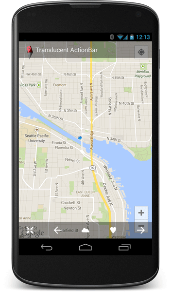
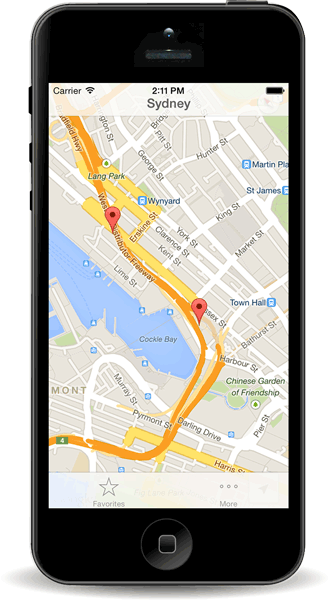
Full screen maps with map padding
Want to add a translucent Action Bar overlay to your map in Android? Or use a full screen layout in iOS 7? Map padding makes it easy to create full screen maps with custom interface overlays. Google Maps UI controls and attribution will automatically be repositioned in the visible area, and changes to the map camera take padding into account, so you don’t need to do this yourself.
Full screen layout maps are more immersive on Android (left) and iOS 7 (right).
Give your markers a sense of direction
We’ve added a marker rotation property, to allow you to rotate a marker around it’s anchor point. The new flat property allows you make the marker lie flat on the map surface, rather than popping out to face the camera. These two new properties are especially useful for indicating compass directions when the map is rotated or tilted.
Marker animations come to iOS
Time to make your markers move! There are a few ways to animate markers on Android, and today we’re adding the ability to animate marker position and rotation on iOS using the Core Animation framework. Animation for these properties happens automatically, but this can be customized if you’d like something a little different, or turned off entirely. You can also animate the icon of your marker using the existing images and duration properties of UIImage.
Playback GPS routes using flat markers (left), or use animated marker icons (right, iOS only).
Platform specific updates
The latest version of the Google Maps SDK for iOS now officially supports iOS version 6 and above, adding support for iOS 7, and removing support for iOS 5.1. Those of you running maps on mathematically intensive applications will be glad to know we have added ARMv7s support (and we’re investigating ARMv8 as well). For the the full list of new features and bug fixes see the Android and iOS release notes.
We’re rapidly adding new features, so if you had your fingers and toes crossed for a feature that isn’t in this release, please let us know on the issue tracker. Lastly, if you have any technical questions that aren’t answered in the developer documentation, post them to the Google Maps Developer Community on Stack Overflow.
Posted by Daniel Schramm, Associate Product Manager, Google Maps Mobile APIs
It’s been a few weeks since the last Fab Friday post. The team has been hard at work on a couple of new videos for you. Take a look:
First up is The Mobile Experience, a new series where Paul Saxman talks about mobile map design. In this episode, Paul talks about building a smartphone interface for browsing a collection of places on a map that can be browsed one handed.
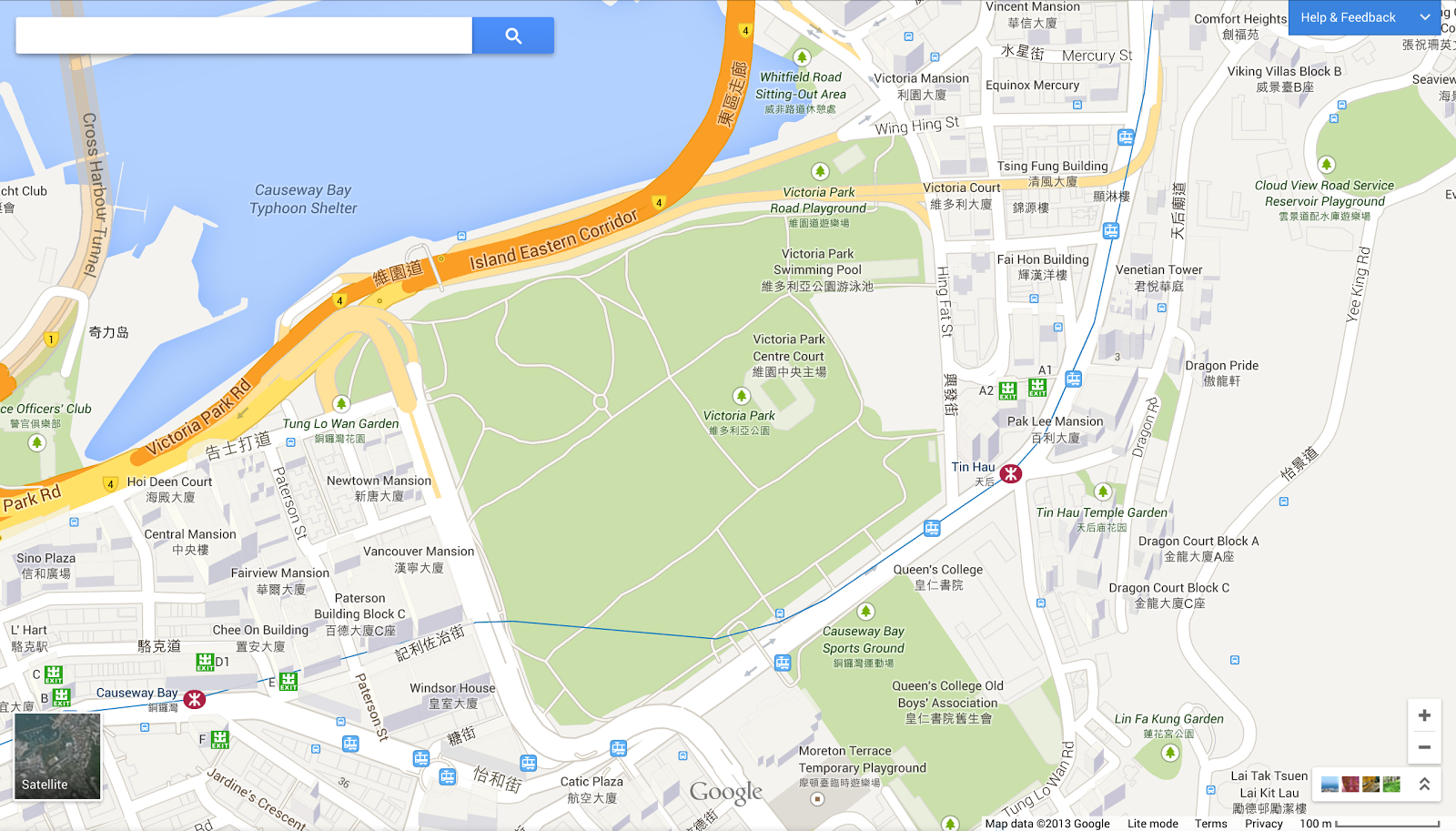
When you travel or look at a map of your city, you want it to be as accurate as possible. We do too. That’s why we’re launching our Ground Truth initiative in Hong Kong and parts of Russia (including Moscow, St. Petersburg, Novosibirsk, Yekaterinburg and large areas in the west of the country), so we can build a better map that helps you find what you need and get to where you’re going, quickly and easily. These new, updated maps for Russia and Hong Kong will automatically become part of your maps using our JavaScript, Android, and iOS APIs. Ground Truth enables us to update a country’s map at a faster pace to provide you with an up-to-date map that mirrors the real world as closely as possible. Ground Truth also makes it possible for you to contribute your local knowledge to the map and report any issues you find through the Report a Problem tool, so together we can build a better map.
The updated maps in Russia and Hong Kong now provide detailed walking paths in many well-known parks and landmarks, making navigating easier especially in pedestrian-friendly Hong Kong. For example, we’ve added walking paths to Victoria Park - you can now zig zag across the park as you please.
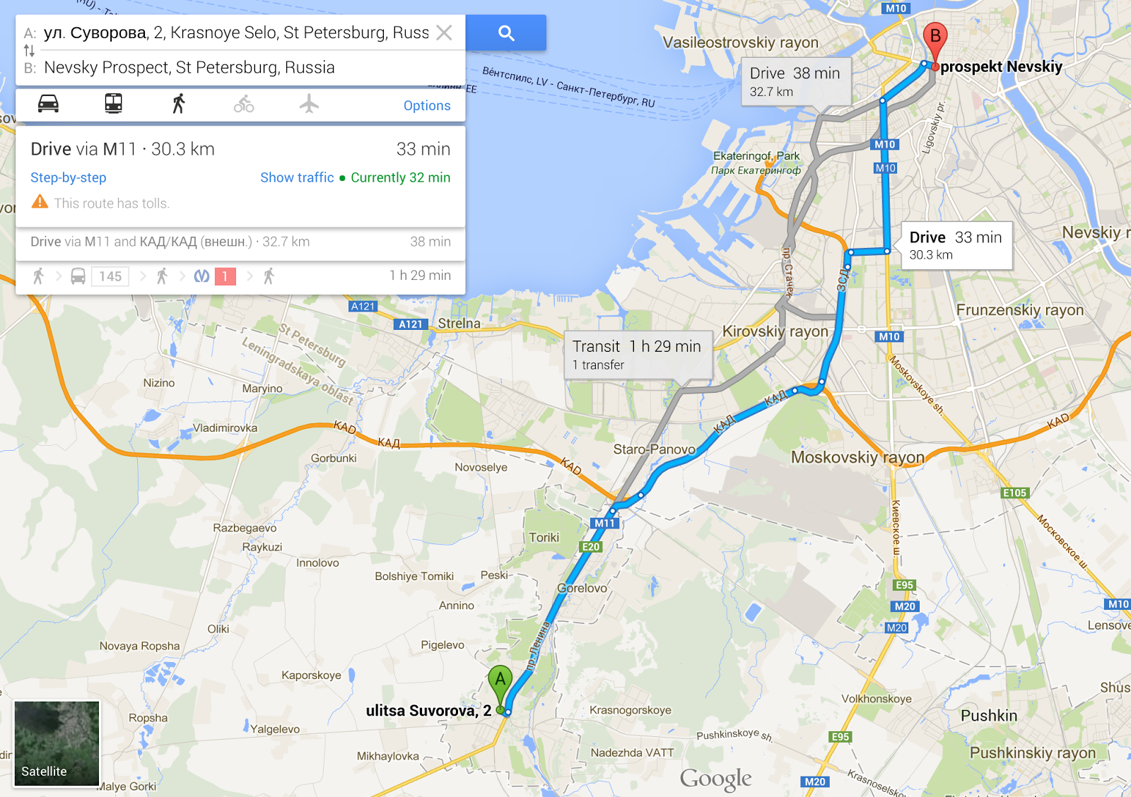
Russia is rather large, so many people prefer to travel by car. Today’s update is good news for drivers as well, as we’ve made big improvements to our road network. We’ve updated street names, turn restrictions and one-way streets as well as completely new maps in more than 50 towns across Russia. So the next time you drive to the city center for shopping, try out the Google Maps app for Android and iPhone to get there.
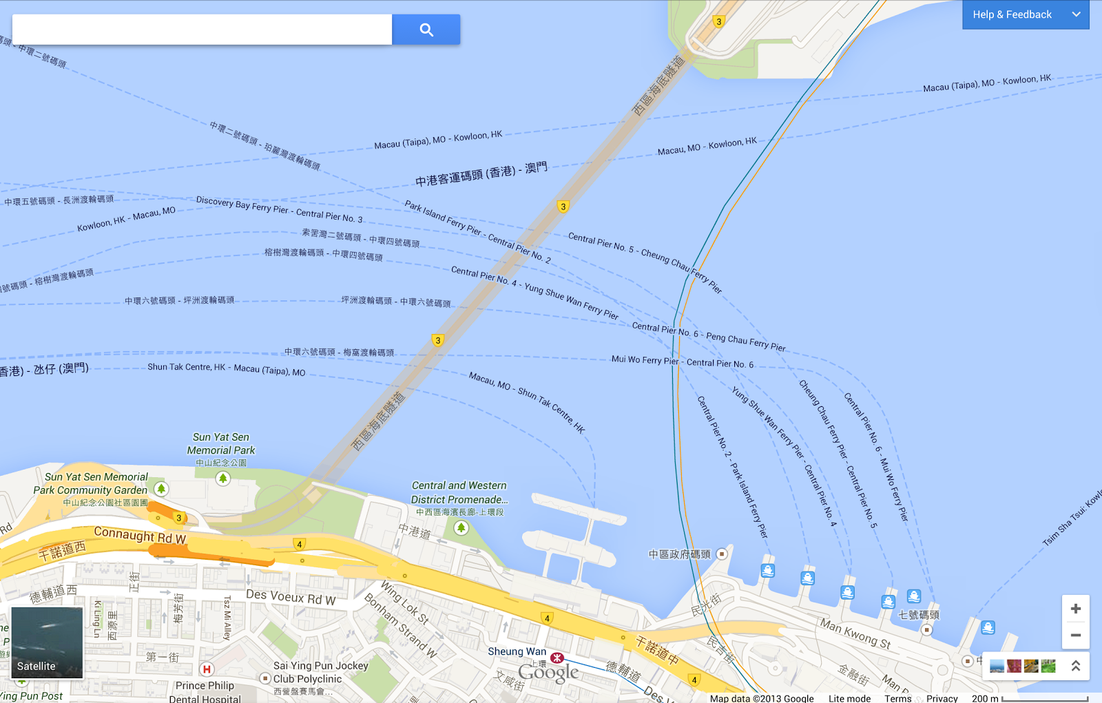
If you’d rather adventure by sea, we’ve also added ferry routes, down to the specific harbor of departure. For example, in the updated map of Hong Kong’s Central and Western District below you can see the ferry routes as well as nearby points of interests and transportation options.
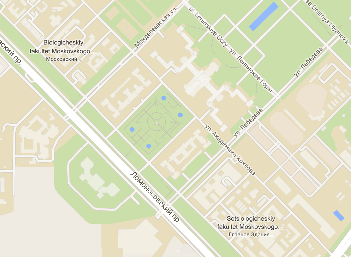
The updated map also indicates places of interest more clearly, such as hospitals, national parks, and universities. For example, Moscow State University, Russia’s oldest and largest university, now has more detail with cleaner walking paths, named roads, and labels for different department buildings.
Whether you’re gazing at the awe-inspiring spirals of St. Basil’s Cathedral in Moscow or strolling through the bustling Tsim Sha Tsui Promenade in Hong Kong, Google Maps is here to help you see, explore, and discover the world!
I’ve also put together this playlist for iOS Developers using our SDK.
For JavaScript developers, Emily Bennett is doing a series of tutorials on Webdesigntuts+ on using the Google Maps API. Emily is the creator of the Portsmouth History Photo Map which we featured as a Map of the Week. She’s got three tutorials up, and one more on the way. Nice work Emily!
That’s all for this week. Have a great weekend and happy mapping!
Posted by Mano Marks, Maps Developer Relations Team