Author Archives: Google Blogs

Explore the hidden worlds of the National Parks

In the Kenai Fjords, the ice is so dense it forms blues brighter than the clear Alaskan sky above. The molten rock around the (very) active Kīlauea Volcano appears to swirl and move — and sometimes it really does! At Bryce Canyon, one of the darkest places in North America, you can see the massive Milky Way glittering across the night sky.

The U.S. National Parks are full of wonders, but most people don’t get the chance to visit in person. While nothing beats the real thing, for this month’s 100th anniversary of the National Parks Service, we wanted to see if we could use Google’s technology to help share the parks with everyone.
Starting today anyone can take a virtual tour of some of our most breathtaking National Parks, no matter where you are, with Google’s The Hidden Worlds of the National Parks.

This Google Arts & Culture exhibit and interactive documentary in honor of this month’s NPS Centennial is available on the web and in the Google Arts & Culture App on iOS/Android. You can immerse yourself in 360-degree video tours through some of the most remote and breathtaking places in five different National Parks. And if you want to learn more about what you’re seeing, you can browse the fascinating archive of artifacts from the National Parks’ many museums.

At each park, a local ranger guides you through places most people never get to go — spelunking through ancient caves at Carlsbad Caverns, flying above active volcanoes in Hawai’i, and swimming through the coral reefs of the Dry Tortugas in Florida.

We’ve also created the Hidden Worlds Expedition for educators to help open up new learning opportunities and share these experiences with even more people. The Expedition can be accessed on the Expeditions App (available on Google Play and iOS in the U.S.).

Today's Doodle celebrating U.S. National Parks & monuments. More info at google.com/doodles.

The National Parks are American treasures, and everyone should see what they have to offer. We hope that by making it easy for people to get a taste of the wilderness, we can encourage a new generation of parks goers to head out and explore in person. Get ready for an adventure!

New JavaScript Street View renderer brings rendering improvements and better mobile support

Street View is one of Google Maps’ most loved features, providing users with a way to explore and experience the world around them. Developers all over the world use Street View in the Google Maps JavaScript API to make their apps more unique and exciting, giving their users a sense of what it’s like to visit a place in real life.


Today we’re making Street View even better, especially on mobile devices, by launching a new Street View renderer in the Google Maps JavaScript API. Read on for the full details of what we’ve improved!


Better display


Smoother Transitions


Transitions from one point to another in Street View now include more animation frames, creating the effect of gliding smoothly to the next location. Transitions in the old renderer looked like jumping from one location to another.


Old renderer


New renderer

next-old-short.gifnext-new-short.gif


Smoother Loading Animations


The old renderer repeats images while loading new content, resulting in a stuttering effect. The new renderer uses lower resolution imagery while loading, resulting in a smoother animation when rotating an image in Street View.


Old renderer


New renderer


old.gif


new.gif


Object modeling improvements


Objects in Street View look better in the new renderer because it builds a 360-degree model that considers all possible perspectives. For example, this high rise building has wavy lines in the old renderer, as opposed to crisp lines in the new renderer.


Old renderer


New renderer


In another example: for imagery on an incline, such as a street with a steep hill, the new renderer corrects the objects to be vertical, whereas the old renderer would have shown the objects at an angle.


Old renderer


New renderer


Better mobile support


WebGL imagery


The new renderer uses WebGL (on browsers that support it) which results in a higher frame rate and better rendering, especially on mobile devices. On mobile devices, the old renderer would display a fish-eye projection of the image, whereas WebGL allows us to present a rendered sphere that looks as it would in reality. For example, the street in the image below is straight, but the old renderer made it look curved on mobile devices.


Old renderer


New renderer


WebGL_before.png


WebGL_after.png


Touch support


As mobile web usage grows, users expect familiar touch-based interactions to work everywhere. The new renderer supports the same natural touch-based gestures on mobile which have been available in the Google Maps Android app: pinch-to-zoom and double-tap-to-go. In the old renderer, zooming was only available through the +/- buttons, and movement was only possible by clicking the arrows on the ground.


Motion tracking on mobile devices


Mobile devices give developers the opportunity to provide their users with more natural ways to explore and interact with their applications. We’ve enabled support for device orientation events on Street View so that users on mobile devices can look around in Street View by moving their phone. Developers have the option to turn this off if they prefer. Please see the developer documentation for more details, or open the documentation link on a mobile device to see motion tracking in action.


Better controls


X Forward


When using a desktop device with a mouse or trackpad, users will see a small "X" at the cursor location that indicates the next camera location if they choose to move forward. Arrows indicate the direction of movement. Wall rectangles identify the direction the camera will point towards.


Next image targets


Next centered image target


Cleaner street names, labels and targets


Street names and labels are now separated from controls, removing overlap issues and allowing for clean display in right-to-left and left-to-right languages.


Old renderer


New renderer


We hope you enjoy using the new and improved Street View renderer! Also a big thank you to all the developers who use the Google Maps JavaScript API and provide feedback via the issue tracker. Getting feedback from developers is vital for us to be able to keep improving our products, so if you have any bug reports or feature requests, please let us know!


For more information on Street View in the Google Maps JavaScript API, please see the developer documentation.


author image

Posted by Elena Kelareva, Product Manager, Google Maps APIs


Meet Google Duo, a simple 1-to-1 video calling app for everyone

Video calling is the next best thing to being with someone in person, but too often it can be a frustrating or complicated experience. You shouldn’t have to worry about whether your call will connect, or if your friend is using the same type of device as you are. It’s no wonder that nearly half of us never make video calls on mobile*.

Today, we’re releasing Google Duo — a simple 1-to-1 video calling app available for Android and iOS. Duo takes the complexity out of video calling, so that you can be together in the moment wherever you are.

Google Duo works across Android and iOS — all you need is a phone number

Simple interface

Duo is simple from start to finish. To get started, all you need is your phone number and you’ll be able to reach people in your phone’s contacts list. No separate account is required, so you can sign up in just a few steps. From there, you can instantly begin a video call with a single tap.

Fast and reliable
We all know how it feels when a call fails to connect or when video gets choppy. We’ve built Duo to be fast and reliable, so that video calls connect quickly and work well even on slower networks. Call quality adjusts to changing network conditions to keep you connected — when bandwidth is limited, Duo will gracefully reduce the resolution to keep the call going smoothly. For video calls on the go, Duo will switch between Wi-Fi and cellular data automatically without dropping your call. You can start your call at home, and continue seamlessly even when you head out the door.

Human design
We designed Duo to feel warm and inviting, focused on just you and the person you’re calling. To make calls feel more like an invitation rather than an interruption, we created a feature in Duo called Knock Knock which lets you see live video of your caller before you answer, giving you a sense of what they’re up to and why they want to chat. Knock Knock makes video calling more spontaneous and welcoming, helping you connect with the person before you even pick up.

Knock Knock in Duo lets you see who’s calling before you pick up

Finally, we built Duo with an emphasis on privacy and security, and all Duo calls are end-to-end encrypted.

Give your friends a wave with Duo! We’re beginning to roll out Duo for Android and iOS today, and it will be live worldwide in the next few days.

https://4.bp.blogspot.com/-yrKJX9bE9ss/V7IQn5bM1NI/AAAAAAAASy0/rBzwE6rPqBc3ZxHpFnAQ4GkY1CU5qt6iwCLcB/s200/Screen%2BShot%2B2016-08-15%2Bat%2B11.56.08%2BAM.png

Dive (or run, swim, vault…) into the Olympics with Google Trends

This year's Olympics in Rio brings together 10,500 athletes from 200+ countries to participate in 306 events, from archery to wrestling. To help you get even more out of the Games, we've created a Google Trends Olympic Hub where you can find fun facts, data insights, feature pages on sports and athletes, and more.

Olympics Trends Hub
Throughout the next few weeks, Google Trends will give you a unique view into the games with a new Trends Hub just for the Olympics. There, you’ll be able to see which athletes, events and moments are captivating audiences—and searches—worldwide. For example, which country is searching for beach volleyball the most? Landlocked Switzerland. And the title of most searched grandmother in the world goes to British swimmer Adam Peaty's nan.

Here’s some of what you can expect from Trends over the next few weeks:
  • Search insights revealing what the world is wondering about the events—from fencing to synchronized swimming (and every moment in between!)
  • Data interactives like our alternative medal table and top searched sports per country
  • Trending sports and athletes lists, showing what’s of interest at any given moment


Explore Trends in a new way
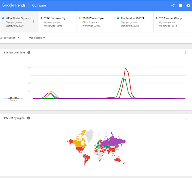
As you explore the site, you may notice something else—a new Google Trends Explore page. With a fresh design and features like a color-coded map, you can analyze search data in new ways. For example, you can compare interest in previous Olympic Games over the years:


Every four years, the Olympics captivate the world’s attention. We’re excited to be able to help fans get even more out of the Games with insights from Search.

https://2.bp.blogspot.com/-qlJ71OdB1rA/V6jpU2BTC-I/AAAAAAAASxc/OqWCwX3M_Ys3WVOo102PdD5dYLgAdiENwCLcB/s1600/Rio_Trends.jpg

Go bananas for the 2016 Doodle Fruit Games

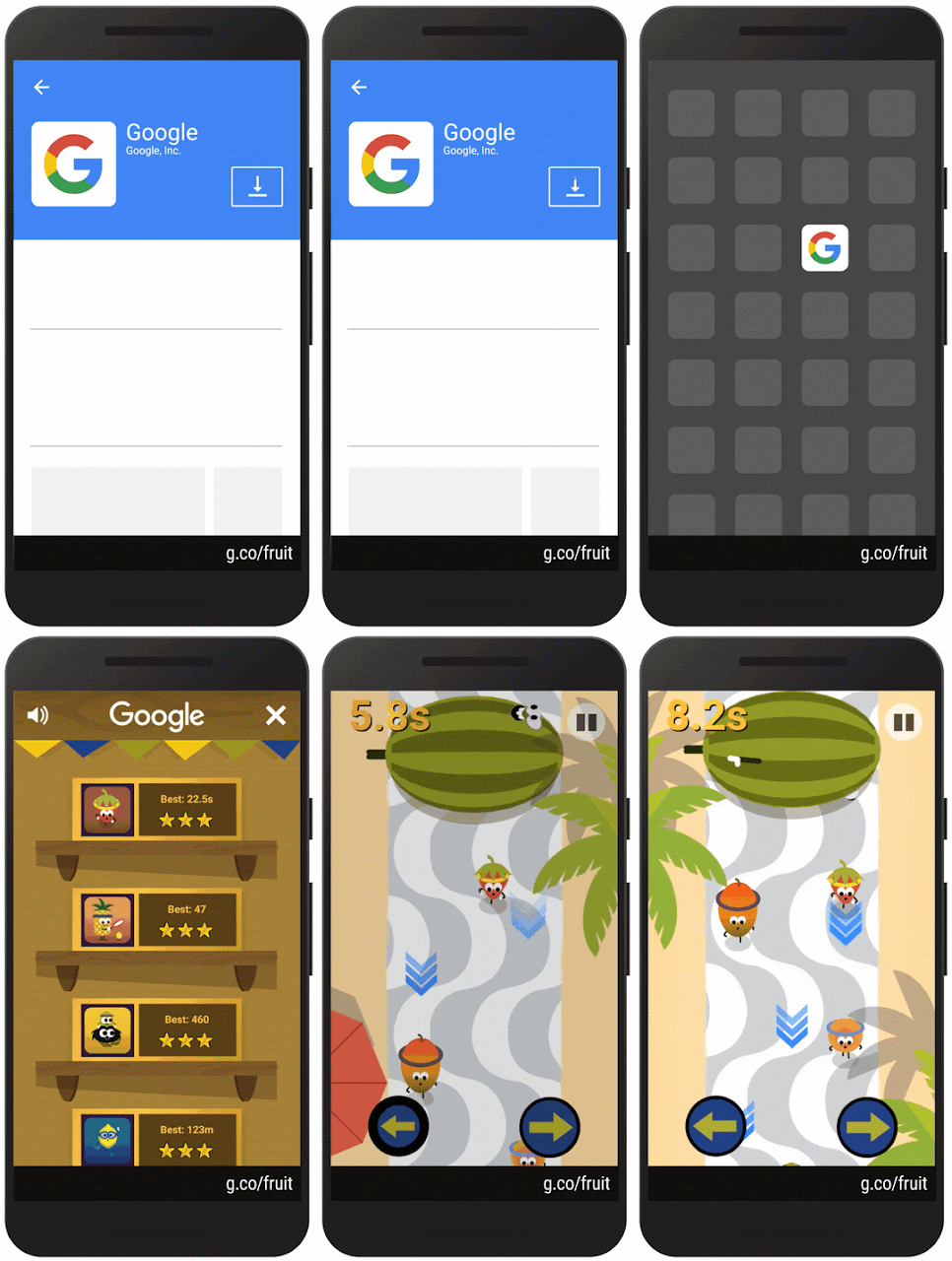
The summer just got sweeter. Today marks the season opener of the 2016 Doodle Fruit Games. For the next couple of weeks in the latest Google app for Android and iOS, journey to an otherwise unassuming fruit stand in Rio, where produce from all over the market are ripe to compete for the title of freshest fruit.


The name of today’s featured game is to see who’s the fastest fruit on the track in this berry special race. Don’t be MELONcholy if your sprint turns into more of a smoothie.


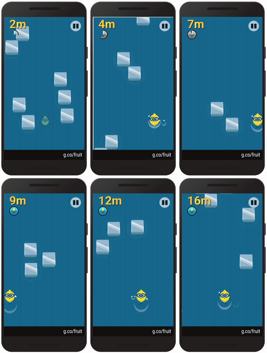
If you like the taste of that, be sure to weave your way through the ice cooler to see if you’re the chillest lemon around. Remember: No one likes sour losers!


We hope you find these fruits as apPEELing as we do. And don’t forget to share your cherry impressive results with friends to see who claims the top seed. These two games are just a taste of what's in store, so come back to the Google app throughout the week to catch the featured game of the day.


https://2.bp.blogspot.com/-xausnUUeFZw/V6OLFnHPhAI/AAAAAAAASwg/7tqruAhwtdsVJhjIBFTqutNRgoYctAH9gCLcB/s1600/peach_autograph.gif

Keep users focused on what’s important with the latest Google Maps Android API

Released today, the latest version of the Google Maps Android API includes more developer requested features: you can now track camera movements more accurately via our new camera listeners, set the minimum & maximum zoom levels on your map, and restrict the user’s panning to particular lat/lng bounds of the camera target. In addition, we’ve added a new marker Tag property so you can now associate your own data object with a marker.


Track camera movements more accurately


As one of our top requests, developers have been asking for a better way to track camera movements and the ability to see why the camera is moving, whether caused by user gestures, built-in API animations or developer controlled movements [Issue 4636]. Our new camera change listeners support you in doing this. Your app can now receive notifications for camera start, ongoing, and end events.


See the developer’s guide to camera change events and take a look at this code sample which shows you how to detect when the user drags the map, and draws a line to track this movement when it happens.


Control the zooming, panning and scrolling experience


Have you ever wanted to be able to control how much your user can zoom in and out and pan around on your map so that you can more tightly control the experience? Or have you got tile overlays only for zoom levels 15 through 20 and wish you could limit the zooming capability of both the map and your tile overlays to those particular levels?


You can now set the min and max zoom levels on your map by using GoogleMap.setMinZoomPreference() and GoogleMap.setMaxZoomPreference() [Issue 4663]. These zoom levels will also apply to any tile overlays you have on your map.


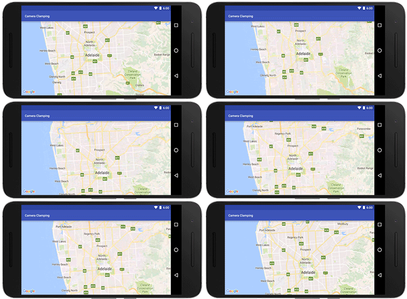
In addition, you can also constrain the lat/lng center bounds of the focal point of the map (the camera target) so that users can only scroll and pan within these bounds using GoogleMap.setLatLngBoundsForCameraTarget(). This is awesome if you want your users to stay within the map area of your tile overlays, or you wish to confine the map in your app to a particular local area.


Pan and zoom limits on a map for Adelaide, a beautiful city in South Australia


See the developer’s guide to learn more about setting boundaries on the map as well as this code sample.


Marker tags


Does your app cater for different types of markers and you want to treat them differently when a user taps on them? Or do you want to assign priorities to your markers? The new marker Tag property allows you to associate whatever data object you like with a marker, supporting you in doing this and more [Issue 4650].


A big thank you to Android developers everywhere for using the Google Maps Android API and submitting feedback via the issue tracker.


Our release notes contain details of bugs fixed as well as the features mentioned in this post. Take a look and start using our new features today!


author image Posted by Megan Boundey, Product Manager, Google Maps Mobile APIs


Let Google be your guide to Rio de Janeiro

The modern Olympic Games have been a defining moment for athletes and fans alike dating back to 1896. Next week, the 2016 cauldron will be lit in Rio de Janeiro, Brazil, where thousands of athletes will come together to represent the strength and pride of their home countries with the world as their audience.

In celebration of the next chapter in Olympics history, we’re bringing the best our products have to offer to help people around the world stay up-to-date with the Olympic Games Rio 2016:

  • Discover the event schedule, medal counts, and athlete information in Search
  • Get results and view TV schedules in 30+ countries
  • Watch official broadcasters’ event highlights on YouTube in 60+ countries
  • Explore Rio and venues in Google Maps
  • Keep up to date with the latest search Trends from around the world

On Google, searching for information about your favorite athletes and sports, the medal race, or your country’s schedule has never been easier. Pro tip: if you search on the Google app on Android and iOS, you’ll also see an option to get automatic updates on top event and medal wins, so you’ll never miss a beat.


To give you a glimpse into the Games, watch official broadcasters’ video highlights on YouTube in more than 60 countries around the world. And as an added bonus, YouTube is sending 15 top creators to Rio, giving you a taste of what it’s like to be there with mobile live streaming.

With Street View in Google Maps, everyone can enjoy the magic of Rio de Janeiro. Even if you’re a world away, preview the places where the world's most talented athletes will make history and explore the breathtaking beauty of Brazil.


Google Trekker operator captures 360-degree imagery from inside Rio’s Olympic Park

Great triumphs, victories and stunning surprises await us all this summer. This is just a hint of what’s to come—we hope you’ll let Google be your guide.

https://lh3.googleusercontent.com/76qfDkapREe1f6uKxqP8OD2FWwLPpbs7U_sojTc9-VgzDlMoy99BQSVkkGltjrWdERaLjSB-0ZfVjXPkBO8uQJkLeRfLYBmlY1p_zsHpYRZkJfkizjOO87hC-Zpbc_JM0iZgTsLo

Explore Rio from every angle

With its beautiful beaches and breathtaking landscape, Rio de Janeiro is a city that appears on every traveler's bucket list. Now, thanks to the wonders of technology, you can now explore the "Marvelous City" and its rich cultural heritage even if you can't make the trip. We partnered with eight of Rio's top cultural institutions to create an interactive online collection of some of the city’s most famous art exhibits and landmarks on Google Arts & Culture. Bem-vindos ao Rio!

Arts, monuments and more
The collection includes 360° panoramas with Street View technology, some 3,000 images from photo archives and art exhibits, virtual reality tours with Google Cardboard and videos showcasing a new generation of Cariocas making their mark in the city's cultural landscape. From iconic monuments and spectacular views, to the history of Guanabara Bay and the majestic Theatro Municipal, these online exhibits capture Rio from every angle.

Take an interactive tour of Rio's best-known monument—the Christ the Redeemer statue perched atop Corcovado mountain—or explore its storied musical history through album covers designed by Elifas Andreato.


Left: Bronze statue of Carlos Drummond de Andrade Right: Exploring Elifas' album covers through time

You can also go back in time by taking a peek at one of the richest collections of archival photographs of Rio, or tag along on a guided tour of the works of Rio-based artist and author Ziraldo, whose comics and children's books have marked the lives of generations of Brazilians.

Take a virtual reality tour with Cardboard

Mapping the whole city
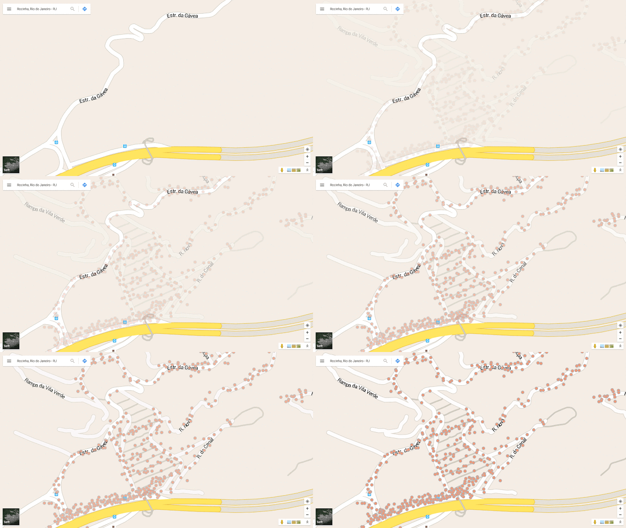
A huge part of Rio’s history and culture resides in the hillside favelas that dot the landscape. In fact, one in five Rio residents live in favelas, but only 0.001 percent of the city's favelas appear on the map. That means 1.4 million people have no addresses to list on job applications or bank accounts, and aren’t able to access many economic opportunities, essential services, even basic rights as citizens. So we teamed up with local NGO Grupo Cultural AfroReggae to map the favelas. Two years later, streets and 10,000+ local businesses in 26 favelas now appear on Google Maps, thanks to "Tá no Mapa," our "On the Map" project.

The Rocinha favela before and after our mapping project


This new online collection opens its virtual doors today at g.co/riodejaneiro on Google Arts & Culture. It is available on the web on mobile, tablet and desktop, and on the Google Arts & Culture app on iOS and Android devices.

With the world’s eyes on Rio, we’re excited to give you a glimpse of all the splendor and creativity the city has to offer!

https://4.bp.blogspot.com/-ZnsjBGqEP3k/V5rGIC2KcZI/AAAAAAAASvM/dkja-J0UdA0DaVMm4r8ERbFB1wrdZlX1wCLcB/s1600/Conservac%25CC%25A7a%25CC%2583o%2BRio%25282%2529.jpg

Google Play Family Library: Share what you love with the ones you love

Friday night is movie night at our home, and my wife and I look forward to our weekly ritual of putting the kids to bed, getting some takeout, and catching up on our movie wishlist. Whether it’s making the BLUE STEEL face from Zoolander, swapping tips on playing Monument Valley, or reading Dragons Love Tacos to the kids at bedtime, these shared moments bring us closer together.

For families like mine, who bond over shared entertainment, we’re introducing Family Library, a way for up to six family members to share purchases on Google Play. When you buy an eligible app, game, movie, TV show, or book in the Play Store, you can now share it with your family—across devices—with no additional sign-up fee.


Share across your family’s devices
Today’s families have a lot of devices, and it should be easy to share content no matter where we are or what we’re doing. Everyone in my family loves the Star Wars movies and we all want to be able to watch them, on our phones, tablets, laptops, or TV. All purchases added to Family Library are available across Android devices, and movies, TV shows, and books can be enjoyed on iOS devices and the web.

Easily manage sharing and family purchases
As with most family matters, flexibility and choice is important. With Family Library, you can choose which items you want to share and which to keep to yourself—for example, I’ll probably keep my collection of comic books in my personal library. Flexibility is also built into your purchasing options. When you sign up, you’ll select a credit card to share as your family payment method, but your family members will always have the option of buying stuff with their personal credit cards or gift cards. And for your younger family members, you’ll have the option to approve each of their purchases.

Share a Music subscription with your family
Finally, if your family loves music, you can also subscribe to the Google Play Music family plan. On this plan, up to six family members can stream millions of songs on demand for $14.99 a month. We launched the family plan late last year, and today we’re expanding it to Ireland, Italy, Mexico, and New Zealand. And you can now sign up on the web, in addition to your Android device.

Starting today, Family Library will be rolling out over the next few days and will be available in Australia, Brazil, Canada, France, Germany, Ireland, Italy, Japan, Mexico, New Zealand, the United Kingdom and the United States. To get started, sign up in Google Play, invite your family members, and start sharing what you love!

https://1.bp.blogspot.com/-3j_0lZ3pI-w/V5ejW8jcoJI/AAAAAAAAStw/ht0F9TZzSeM5ssT7p3rZSoJCiIWb7LReACLcB/s200/FamilyPlay.jpg

Google Places API for iOS & Google Maps SDK for iOS are now in separate CocoaPods

In today’s release, the Google Places API for iOS 2.0 and the Google Maps SDK for iOS 2.0 are now in separate CocoaPods. For developers who only use the Google Places API for iOS, this will significantly reduce the binary size of their app.


What does this mean for me? What do I have to do?


Nothing immediately for your current implementation, but we strongly suggest that you upgrade within the next year to the new Google Maps SDK for iOS 2.0 and Google Places API for iOS 2.0. The Google Maps for iOS SDK Version 1.x will become unsupported in one year’s time.


If you are using the Standard Plan Google Maps SDK for iOS 1.x, and haven’t specified a version in your podfile, you will be automatically upgraded to the new Google Maps SDK for iOS 2.0 when you run ‘pod update’. If you use any Places functionality, we’ve created this migration guide for the Places API to step you through the process of migrating to the new Google Places API for iOS 2.0.


In addition, we’ve documented how to extract all the frameworks (Maps, Places) from the relevant CocoaPods so you can manually include the SDKs in your project rather than using CocoaPods if you wish. [Issue 8856]


What does this mean for Premium Plan Maps SDK customers?


There is no longer a separate Google Maps Premium Plan SDK. Instead it has been replaced with the new streamlined Google Maps SDK for iOS 2.0 for both Standard and Premium Plan developers.


We’ve created a Premium Plan migration guide that will step you through the process of migrating to the new Google Maps SDK for iOS 2.0. We’ve also documented how to extract the frameworks from the CocoaPods so you can manually include the SDKs in your project if you’d prefer that. Your Enterprise Maps key will continue to work, as will your Premium Plan.


Please note:

The Google Maps SDK for iOS Premium Plan SDK 1.13.2 (current version) will be supported for one year during which time we suggest you upgrade to the new streamlined Google Maps SDK for iOS 2.0.


Take a look at our release notes and start using version 2.0 today!


author image

Posted by Megan Boundey, Product Manager, Google Maps Mobile APIs